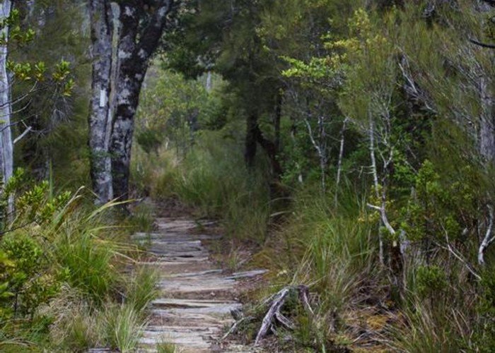
For a description of the climb from Nelson onto the saddle before Dun Mountain and over to Rocks Hut, see the Dun Mountain track description. Rocks Hut is a fine building perched high on a ridge overlooking the Pelorus River witb large windows and a generous porch giving good views south.
Rocks Hut to Roebuck Hut
The direction that you travel the loop from Rocks Hut depends on the weather. If it is raining heavily then I suggest that you reverse the loop as described here. The reason is that Rocks Creek is prone to flooding and has no bridge across it. Hopefully the weather will clear and the creek subside if you head off to Browning Hut first.
The track departs the hut clearing through a gap just before the hut and in a few metres meets a junction. The track to Browning Hut goes off to your right while we go straight ahead and down. The track heads steadily downward through a mixture of rata and beech forest. At first it is very clear on the ground but it soon becomes more lightly padded. The steady drop brings a junction in 2 hours (there is a bit of a viewpoint about 20 minutes before the junction). The track upriver is signposted to Roebuck Hut (3 hours over 5 kilometres away) but a diversion to Middy Hut is recommended.
Continue straight ahead, down towards the river for another 10 minutes until the gradient lessens and the track heads along a spur above Middy Creek. A swingbridge across the Pelorus River is reached after a further drop at the end of the spur. The hut is in a grassy clearing about 100 metres downriver via a narrow path along a vertical hillside. A good place for a lunch break and to refill your water bottles with sweet river water. However the swarms of sandflies along the riverbank may restrict your visit to the hut clearing. Return the same way to the junction (45 minutes for the diversion).
Back at the junction, the reason that the signpost has the track stretching for 3 hours over only 5 kilometres is that the track is not a riverside stroll. Rather it is a thin goat track perched well above the river and traversing across steep slopes. The first half kilometre is fairly easy with a gentle climb and descent into a minor unnamed creek. The climb out from the creek rises to a disconcerting little saddle where you actually head straight away from the river. The drop down to Rocks Creek is a bit cruel but quickly over. The track actually heads down stream for a bit (contrary to the map), sidling over steep slopes and a nasty wee slip. The wide expanse of gravel in the creek bed is a good spot for a break.
Cross Rocks Creek at the second side-stream between 2 pairs of orange markers (a few metres down from where the track emerges). There is a rugged climb over the end of a ridge to the next major unnamed creek. Note that when I passed along here there was a large tree across the track needing a great deal of effort to get around. The creek is just short of halfway to the hut and the climb up from it features a rocky scramble over wet rocks at the top of a small cliff. A wire rope makes this a bit safer. After this the track is straight forward with no great surprises for the next 1.5 kilometres.
A small creek signals the approaching Roebuck Creek (about 200 metres away) and the first high swingbridge to the other side. If you look down to the junction with the river when crossing the swingbridge then Roebuck Hut can be glimpsed on a high river terrace on the far side of the river. The track ducks down an eroded gully to the riverside and then upriver to climb up to the junction with the track to Browning Hut. The swingbridge across the Pelorus is a little further upriver. A short bluffy section then leads back downriver to the hut. At the back of the hut is a track (now unmaintained) that climbs up to Conical Knob and then heads south along the extremely tough ridge towards Mt. Richmond, reaching another hut in 8-9 hours for a fit party in good weather.
Roebuck Hut to Browning Hut
This day is quite easy. The steepish climb at the start of the day leads to an enjoyable sidle to Totara Saddle at the head of Roebuck Creek and a short descent to the hut. In fact a fit party can forget about Browning Hut and head straight up back up to Rocks Hut. This turns an easy 5 hour day into a harder 9-10 hour day.
Start by retracing your tracks back along the river bluffs to the bridge across the Pelorus River and up to the track junction passed the previous day. This heads steeply up the ridge between the river and Roebuck Creek. The slope relents a little after you get a bit above the river but there is still about 300m to climb over the half kilometre to the knob at point 493m. The reward is some fine stands of large trees as the track heads further along the ridge and some flat patches to catch your breath in. The track turns to head directly west on the knob.
Over the next 2 kilometres from the knob the track climbs again easily up to the 600m contour and then begins to sidle along the ridge slopes above Roebuck Creek. The general trend is to continue to climb, however the highest point reached is just over 700m. A couple of slips and glimpses through the trees reveal the fine ridge on the other side of the creek. This is the route for tomorrow and the tussock meadows below point 906m can be appreciated as you near Totara Saddle.
The track drops down into the moist ground below Totara Saddle and then climbs shortly to the saddle itself. There is a well-signposted junction with the track up Rocks Ridge a little further down the track. It is quite possible to get to this point in 4 hours from Roebuck Hut. Unfortunately the track becomes steep, eroded and muddy for the next 200 metres as it drops into the valley of Browning Stream. Conditions improve after the stream is met. The map implies that the track goes right by the hut but the hut is actually a few metres across a stream at a grassy clearing on the track with enormous signs. The stream is the water source for Browning Hut. One advantage of approaching from the saddle is the chance to inspect the stream and notice little details like the rotting possum carcass on the track just before the hut - you may be sure I got my water from further upstream!
Browning Hut to Rocks Hut & Nelson
Yet another easy day back to Rocks Hut - a bit longer than yesterday but with easier climbs. I had the misfortune to met with the worst weather of my trip. The heavy overnight rain had stopped but the cloud was looming around the hut and only got thicker as I ascended.
Return to the junction at Totara Saddle about 45 minutes from the hut. The track then heads north up a narrow ridge to reach point 822m after a kilometre (140m climbed). There is a turn to the NE and gentle climbing to the edge of the first tussock meadow in about 200 metres. The track is marked by cairns in the meadows. These are quite frequent and especially handy when you can see only about 20 metres as I found.
The tussock ends when you enter bush again at point 906m, 1.5 kilometres from point 822m. A sharp descent to a saddle leads to the "steepest" climb of the day - 150m over 400 metres to the highest summit of the day at 1031m. From there to a junction (about half an hour before the hut), the track strolls for a couple of hours over various bumps. It can become very wet after heavy rain or in the rain that I found myself but the water tends to flow along the track rather than forming mud.
The junction is with a track that goes out to a viewpoint near The Rocks (which the ridge and hut are named after). It is also in this area that a couple of awkward streams have to be crossed. Normally the streams here are just ankle deep but after the heavy overnight rains I was faced with overflowing streams. One I had to throw my pack over first and then take a flying leap. Nearing another stream, the track was overtaken with fast boot-deep water before a turbulent junction that had to be avoided by bush-bashing a few metres upstream. Luckily the hut is quite near so you need not fear wet boots that much.
The return to Nelson can be by the same route as the approach but there are a couple of alternatives.
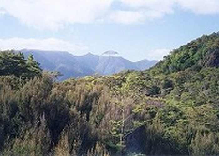
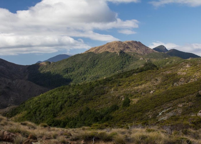
The first alternative branches off at Dun Saddle where a track heads north above the valley of the Maitai River. It only takes a couple of hours to get down to the Maitai Dam (3 hours from the hut) so it is the closest road end but you will need to arrange a lift into Nelson from the dam. If you do have transport at the dam then there is a longer, more interesting route over Dun Mountain that takes 5-6 hours. The first 15 minutes are spent on a steepish climb of 100m but the gradient is easier afterwards as the track climbs the ridgeline to Dun Mountain Hut (really a shelter). The summit of Dun Mountain is about 10 minutes further from the hut up a moderate slope. There are great views to the east along Pelorus River with Pelorus Sound pointing the way to the open sea. Northwards there is the sweeping expanse of Tasman Bay with a glimpse of Nelson along the shoreline. To the west are the rolling hills dropping to the plains behind Nelson. The highlight is the view to the south where the massive Richmond Range shows its serrated tops to the best advantage. Continue north-east along the poled route. This drops down to a saddle and then enters bush for a climb up to Little Twin (1143m). The track then descends to a broad saddle containing the Dew Lakes (small mountain tarns). About 100 metres before the lakes a path branches off down a ridge to arrive at Maitai Dam in 2 hours.
The second alternative leaves from Third House Shelter and adds about an hour to the day. Rather than continuing along the walkway, take a thinner but clear track descending west from the shelter through good bush. A ridge is followed over a couple of bumps, up to a high point of 873m and then 500 metres further to a junction with the Barnicoat Walkway. Turn north over Jenkins Hill (775m) and along a ridge with scrubby slopes to the left and greener bush to your right. The walkway emerges on Brook Street just above the motor camp.