United Mine
- 5 hr return by the same track
- Easy/medium
- Car park to Champion Smelter site: 1 hour 20 minutes
- Smelter site to end of tramway: 20 minutes
- End of tramway to United Mines: 40 minutes
- Roding Valley waterwords, The Prow
- Aniseed Valley Copper, The Prow
- The Champion Copper Smelter (PDF)
Nelson Provincial Museum educational resource
Walk to a smelter site and coppermine on the Roding River near Nelson.
|
Walking time
|
1 day
5 hr
|
|---|---|
|
Distance
|
12.0km |
|
Type
|
Return by the same track
|
|
Grade
|
Easy/medium |
|
Bookings
|
No bookings — open access
No — open access
|
|
Starts
|
Roding Waterworks Reserve car park, end of Aniseed Valley Road, Hope |
|---|---|
|
Maps
|
NZTopo50-BQ26
|
|
Altitude
|
180m
–
570m
Altitude change 390m
|
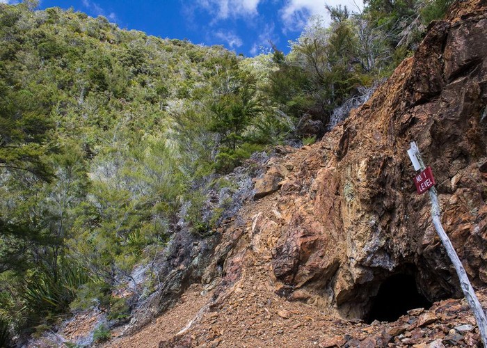
The Roding Waterworks Reserve is located at the end of the long and winding Aniseed Valley Road. Further upriver are several mining sites. Copper was discovered in the valley in 1881, and mined for the following 30 years. It was in high demand due to the electricity lines.
It is an easy walk into the dam and smelter sites, and a rougher journey up to the mines, perched high on the valley walls. A route crosses between the United and Champion mines, but that is not described here. The walk to the smelter site is a good family walk with wet feet, but the mine tracks are considerably rougher. Note that hidden mine shafts are located in forest near the tracks.
From the new car park (and toilet), cross the bridge and follow the trail past the caretaker's house. A vehicle track leads along the river, climbing quickly to a junction.
The Roding River has supplied the city of Nelson with drinking water since 1941, and currently supplies one third of the city's requirements via a 2.7km pipeline that runs through the nearby hill. Take the left branch for a quick visit to the dam. There is another toilet here (a hint not to contaminate Nelson's drinking water?).
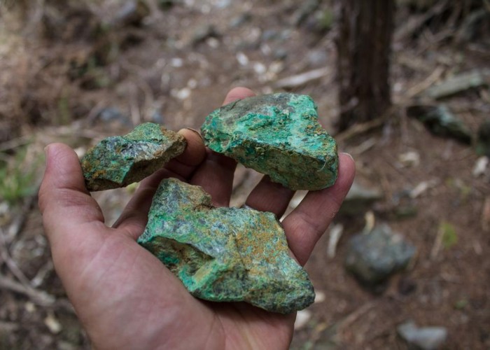
Head back to the main track, which sidles high above the river, sunnily under pine trees, and soon fords to the true right bank. This side of the river is beech forest, and the track heads into the forest. Pass the turn off to the Champion Mine in a few minutes, then ford to the Champion Smelter site in a clearing on the true left bank. The remains of the brick smelter are still on the site along with a dubious looking chimney. There is also a picnic table and, yes, a toilet. Green stains in the scattered rocks are verdigris or copper carbonate. From here, another side trail leads to the Champion Mine.
Instead, continue upvalley, fording the river again and following an old tramway. This runs out abruptly where a riverbank has collapsed. Cross here to a rough track marked with Permolat, and leading steeply to the mine sites. The kanuka scrub here indicates that this was once all cleared.
After about 15 minutes' climb, you will come out onto the mullock heap. No. 2 level United Mine is just uphill from here. No. 1 level mine is five minutes further, a steep clamber up the slippery pile of tailings. There were once 37 miners down these dingy little holes.
From here, you can return the way you came, or take the loop route to Champion Mine, which is marked at the No. 2 level.
Walking times:
Further reading: