Wooded Gully - Pinchgut Hut
Mt Thomas Forest
- 2 days return via same track
- Medium
An overnight trip near Mount Thomas following unmarked trails to a comfortable hut.
|
Walking time
|
2 days
9 hr – 10 hr
|
|---|---|
|
Distance
|
18.0km |
|
Type
|
Return via same track
|
|
Grade
|
Medium
Some sections are not maintained by DOC and may be overgrown or unmarked. Grades explained
|
|
Bookings
|
No bookings — open access
No — open access
|
|
Starts
|
Mount Thomas car park, Hayland Road, west of Loburn |
|---|---|
|
Maps
|
NZTopo50-BW23
|
|
Altitude
|
340m
–
1,043m
Altitude change 703m
|
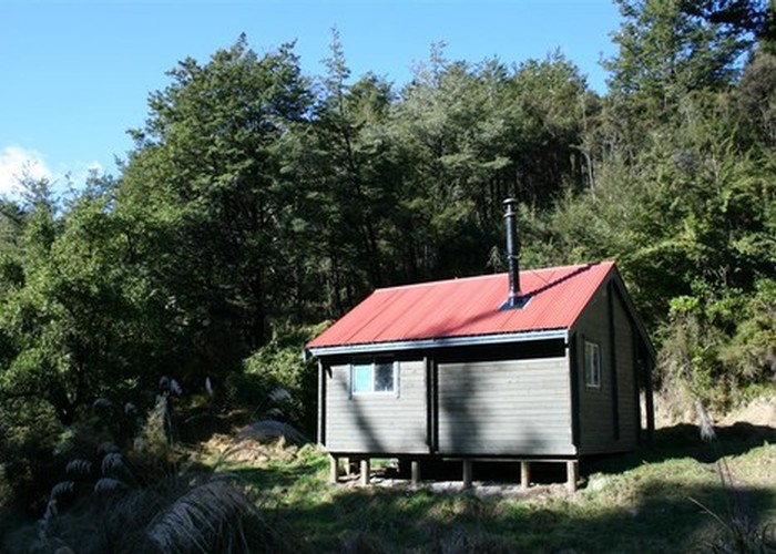
Pinchgut Hut is a relatively new hut near the Okuku River in Mount Thomas Forest. Two routes lead into the hut. A shorter track follows the Okuku River, and provides a popular easy tramp just a short distance from Christchurch. An alternative route begins from the Mount Thomas car park, climbs onto the ridge west of Mount Thomas, and follows a spur down to the hut. This route is described here. Both routes can provide good winter tramping options. As the hut is popular but small, a tent, or at least a bedroll would be a good idea.
From Rangiora, cross the Ashley River and take the road to Loburn. Turn west onto Hodgsons Road, and turn off at Hayland Road just before the Garry River. A car park, picnic area, and camping area are located at the foot of Mount Thomas.
Take the Wooded Gully Track (see Mount Thomas for detail) to the bush-covered ridge and turn left toward the top of the Ridge Track, an alternative route down. After fifteen minutes (2 hr from the start) the track breaks onto tops with good views over the Okuku Range and Ashley Forest to the Southern Alps and distant Kaikoura Ranges. Southeast, Banks Peninsula is visible across the plains. Beyond the signposted Ridge Track turnoff, the route becomes unmarked and the track largely disappears. Follow the descending rocky ridgeline to the northwest until it leavels off and rises again into forest. An unmarked but easy trail continues through the forest to a bush summit. A trail continues through to Bob's Camp Bivvy, and our trail drops along the spur to the right. This trail descends through forest and crosses patches of open flats. Be sure to keep on top of the spur to avoid losing the trail, although there is inevitably some pushing through kanuka and scrub.
Just beyond a steep, scrubby bank, the trail passes some cabbage trees and an odd fenced enclosure, and opens onto a grassy slope. Bend left and keep to the left edge of this clearing. A trail winds into scrub (look for cairns or markers tied to trees) and begins a quick, gorsy descent to the hut, located in a small, frosty clearing alongside Pinchgut Stream.