Dusky Track
Fiordland National Park
- 8 – 10 days one way
- Medium
- Lake Hauroko to Halfway Hut: 4-6 hours
- Halfway Hut to Lake Roe Hut: 3-5 hours
- Lake Roe Hut to Loch Maree Hut: 5-7 hours
- Loch Maree Hut to Supper Cove Hut: 6-8 hours
- Loch Maree Hut to Kintail Hut: 6-8 hours
- Kintail Hut to Upper Spey Hut: 5-7 hours
- Upper Spey Hut to Wilmot Pass Road: 4-5 hours
- Wilmot Pass Road to West Arm, Lake Manapouri: 45 minutes
This journey explores the glacial valleys and mountains of Fiordland from Lake Hauroko to Lake Manapouri, visiting Dusky Sound along the way.
|
Walking time
|
8 – 10 days
40 hr – 55 hr
|
|---|---|
|
Distance
|
84.0km |
|
Type
|
One way
|
|
Grade
|
Medium |
|
Bookings
|
No bookings — open access
No — open access
|
|
Starts
|
Hauroko Burn Hut, Lake Hauroko. A scheduled boat service runs to the head of the lake. |
|---|---|
|
Ends
|
Wilmot Pass Road, West Arm, Lake Manapouri. A daily boat service runs across the lake. |
|
Maps
|
NZTopo50-CE05
NZTopo50-CD06 NZTopo50-CE06 |
|
Altitude
|
Sea level
–
1,096m
Altitude change 1,096m
|
|
Link
|
www.doc.govt.nz/parks-and-recreation/places-to-go/fiordland/places/fiordland-national-park/things-to-do/tracks/dusky-track/http://www.doc.govt.nz/parks-and-recreation/places-to-go/fiordland/places/fiordland-national-park/things-to-do/tracks/dusky-track/ |
|---|
The Dusky is a classic route, eschewing the crowds and heading deep into Fiordland. From the head of New Zealand's deepest lake, it leads up the Hauroko Burn up onto the tarn-studded Pleasant Range, Next, the track drops to Loch Maree and the Seaforth River, following it out to Supper Cove, a tantalising glimpse of Dusky Sound. Returning, the track keeps to the Seaforth, and climbs over Centre Pass before finally dropping down the Spey River to finish up on the shores of Lake Manapouri.
It's not an especially long journey and never too high. But it is rough, muddy, and wet, with flooding making sections impassable regularly. Note that the Department of Conservation recommends against camping on the Dusky Track.
Access
The track ends are on Lakes Hauroko and Manapouri. A launch operates daily from Manapouri village to the track end in the West Arm. A launch operates Mondays and Thursdays November to April on Lake Hauroko -- or by arrangement. Road transport between Tuatapere and Te Anau or Queenstown is available via the Tracknet bus service. The track may be walked in either direction, but with inevitable delays due to weather, starting at Lake Hauroko is most convenient for transport. Another alternative is to take a floatplane or helicopter to Supper Cove and walk the four-day journey back to either track end.
Flood hazards
After continual rain, the Seaforth River can become impassible at Loch Maree as access to the walkwire can be impeded. There is a shelter next to the track at this point. If descending from Lake Roe Hut, a pit day may be in order. The section of the Seaforth River from Loch Maree to Deadwood Creek is floodprone and difficult going in wet weather.
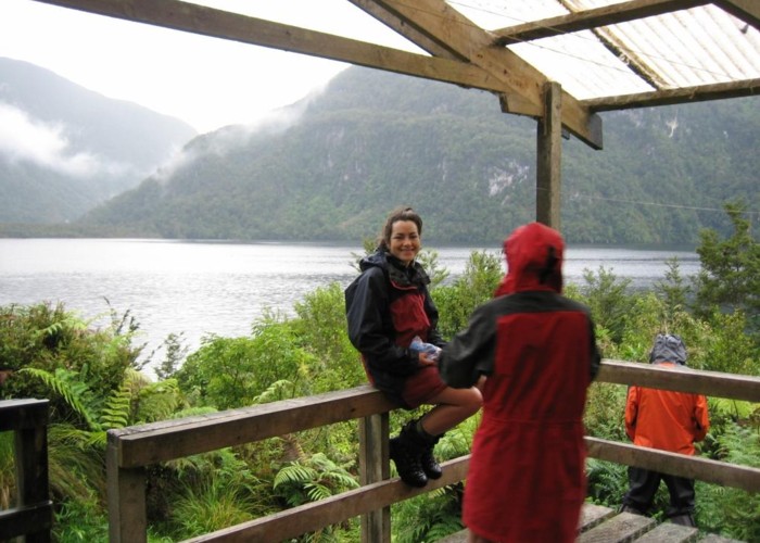
Lake Hauroko to Halfway Hut
Hauroko Burn Hut is located at the track terminus. From here, the track follows the river easily, with a walkwire over one side-creek. Easing past a gorge, the track crosses Hauroko Burn on a wire then climbs around a corner at the Gardner Burn junction. An easy trail leads to the hut.
Halfway Hut to Lake Roe Hut
Continuing upriver, the track crosses several walkwires to the head of the valley. It climbs quickly over the treeline, poles marking the way. The track meets Lake Roe Hut at Furkert Pass. Lake Roe Hut is actually sited next to Lake Laffy -- Lake Roe is a 20 minute walk above the hut to the east. Tarns and lakes are scattered all over the tops of the Pleasant Range.
Lake Roe Hut to Loch Maree Hut
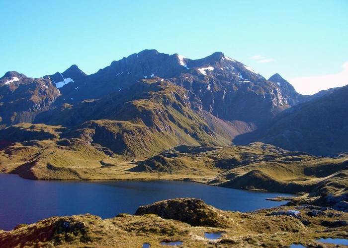
The poled track leads westward across tops, past Lakes Horizon and Ursula, to climb onto a granite ridge overlooking the expanse of the Pleasant tops as well as Dusky Sound. The Dusky Track's high point of 1096m is here. A swift descent off the tops and into forest leads to a crossing of the Seaforth River at Loch Maree. A walkwire is here if needed.
Loch Maree Hut to Supper Cove Hut
The detour to Supper Cove is a full day in each direction. Edging around Loch Maree, the track joins the Bishop Burn briefly and follows a mining trail cut in 1903 out as far as Henry Burn. Beyond here, the track sidles beneath towering slopes to Supper Cove Hut (several walkwires along the way).
Loch Maree Hut to Kintail Hut
From the hut, the track sidles up the Seaforth River, passing a flood-prone section to Deadwood Flat. The Braan Mountains rise to the west, while the Kilcoy Mountains are to the east, and the Dingwall Mountains are straight ahead. The track bends around Tripod Hill and climbs to Gair Loch and and a wire over the Seaforth. Don't cross it: Kintail Hut is along a short side trail from here.
Kintail Hut to Upper Spey Hut
Back at a walkwire, cross it and follow Kintail Stream then a spur up to Centre Pass (1051m). Mount Memphis (1405m) is a straightforward climb from here in good weather (2 hours return). Descending from the pass, the track comes to Upper Spey Hut.
Upper Spey Hut to Wilmot Pass Road
The final leg sets off to the northeast over a damp clearing and down the Spey River. Over some walkwires, and the track keeps to the true left and eventually meets Wilmot Pass Road.
Wilmot Pass Road to West Arm, Lake Manapouri
Follow the road 3km down to West Arm Hut, and another kilometre down to the harbour itself.