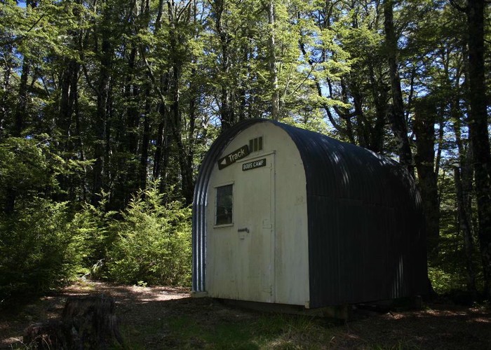
Bob's Camp Bivvy
Mt Thomas Forest
- 6 hr 30 min – 7 hr loop track
- Easy/medium
An easy day or overnight walk through beech forest and along easy ridges to a cute and comfortable biv.
|
Walking time
|
1 – 2 days
6 hr 30 min – 7 hr
|
|---|---|
|
Distance
|
17.0km |
|
Type
|
Loop track
|
|
Grade
|
Easy/medium |
|
Bookings
|
No bookings — open access
No — open access
|
|
Starts
|
Wooded Gully Camping Area, Hayland Road |
|---|---|
|
Maps
|
NZTopo50-BW23
|
|
Altitude
|
340m
–
1,046m
Altitude change 706m
|
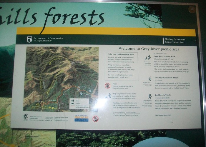
From Rangiora, cross the Ashley River and take the road to Loburn. Turn west onto Hodgsons Road, and turn off at Hayland Road just before the Garry River. A car park, picnic area, and camping area are located at the foot of Mount Thomas.
The Ridge and Wooded Gully Tracks both lead up to the Bob's Camp route. However, the Ridge Track sets off through plantation forest and can be hard to find. It is better as a return route.
Take the Wooded Gully Track along a creek through black beech forest . After several shorter side tracks, the Wooded Gully Track drops to the creek and crosses it to climb easily to the forested ridge (1.5 hours). A gentle climb leads west along the ridge and out onto tussock tops. Nearby, the Ridge Track leads back down to the car park (15 minutes from the top of Wooded Gully).
The poled route continues onto a rocky ridge that drops into forest. 5 minutes in, the track bends down north to Pinchgut Hut and the Bob's Camp Route leads off to the left. This junction is marked by a sign (35 minutes from the Ridge Track).
The track from here was cut by DoC in March, 2015 and is in good condition and easy to follow. Eventually the track opens out onto scrub and tussock and follows poles. These lead over to the northern flank of an easy hill and drop down a boggy slope of red tussock. The track is well marked to keep you to the bush edge for drier feet. The biv is just a couple of minutes into the forest at the bottom of this slope (1 hour 20 minutes from the Pinchgut junction).
For a two-bunk biv it is relatively large and comfortable with shelves and an outside fireplace. There is a little space for camping around the hut, and a trickle of water available from a stream just beyond the fireplace.
A return down the Ridge Track takes 1.5 hours. The walking is easy, under beech trees then through damper forest just before the track breaks onto forestry scrub. Currently the land here is freshly logged and the track is not visible at all. Take the logging road back down to the camping area.