Welcome Flat
Westland / Tai Poutini National Park, Te Wāhipounamu - South West New Zealand World Heritage Area
- 2 days return by the same track
- Easy/medium
- Bookings required
A frosty West Coast valley leading to good hot pools and magnificent mountain scenery on part of the Copland Track.
|
Walking time
|
2 days
12 hr – 16 hr
|
|---|---|
|
Distance
|
34.0km |
|
Type
|
Return by the same track
|
|
Grade
|
Easy/medium |
|
Bookings
|
Bookings required
Required
Bookings required for Welcome Flat Hut and tent sites. No bookings required to use track or other huts.
|
|
Starts
|
Karangarua River bridge south of Fox Glacier |
|---|---|
|
Maps
|
NZTopo50-BX15
NZTopo50-BX14 |
|
Altitude
|
40m
–
480m
Altitude change 440m
|
The Copland Track is an historic crossing of the Main Divide between Mount Cook village and the West Coast. It has been popular with capable travellers since the 1890s when the track was formed under supervision of the great explorer, Charlie Douglas. Before World War II, horses were taken from Welcome Flat to the nearest road at the coast glaciers.
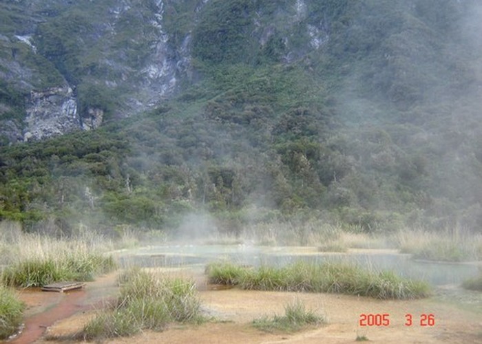
The Welcome Flat Hut is a modern, two storey lodge. The hot pools nearby are are large and reliably hot, and certainly the best free pools you'll find in the South Island. While the walk in to the pools is very popular throughout the year, many visitors are misled about the track. The walk in is long and an early start is essential. There are a number of small flats along the first half of the track, so you could break up the long walk in by camping on one of these. Bookings are compulsory for Welcome Flat Hut to use the Hut or camp nearby, and wardens are in residence year-round - if you arrive to camp without a booking they will charge you double - be warned!
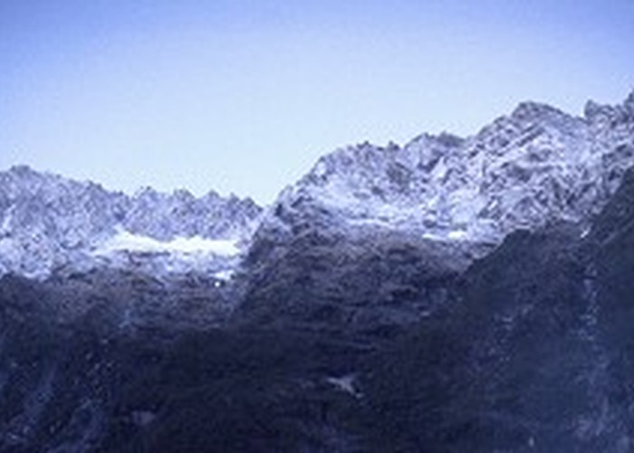
An unexpected reward of the visit is the view of the magnificent Sierra Range. Rising from the opposite bank of the Copland River, the saw-toothed ridge surpasses vertical at several points. It is a short walk from the hut to Welcome Flat itself, and if you have some spare time, you can visit Douglas Rock Hut farther up the valley as a day trip (it is a good excuse for spending an extra night).
Access
It is 26km from Fox Glacier township south to the one-lane bridge over the Karangarua River. Immediately north of the bridge a sign indicates access to the Copland Valley. A shelter is located at the roadside, where trampers can wait for buses. The area is busy with sandflies.
A short road leads to a car park, information board and intentions book, along with a memorial to Charlie Douglas. There is grassy camping here.
Car park - Welcome Flat Hut: 7-8 hr in, 5-6 hr out
All major side creeks have flood bridges, including Shiels Creek, which has a new bridge, and no longer strands trampers during rain. Please note however there are points where small streams cross or follow the track after rain.
From the car park, cross Rough Creek to the marker and follow the bush track. Initially the track is rough-going as it scrambles along by the river bank. It soon evens out, crossing some open space and meeting the old, straight bridle trail. A side track leads to a view over the junction of the Copland and Karangarua Rivers. Beyond here, the track enters the Copland Valley, soon dropping to the lichen-crusted boulders beside the river and sidling beneath a vertical cliff for some time. Climbing out of the river-bed, the track crosses an ironically sign-posted "unnamed creek," followed by McPhee and Architect Creeks. Architect Creek is wide and the bridge is a long span.
The ascent becomes evident from here. A series of wet, steep slips follow on from Architect Creek. The track struggles to traverse across the loose scree and there are a few rockfall areas. After Open Creek and Shiels Creek, which is an avalanche chute, the track climbs to its highest point in a forest of mountain scrub. The descent to the hut is easy. Clouds of steam hanging in the air to the left of the track announce the presence of the pools.
Hut and surrounds
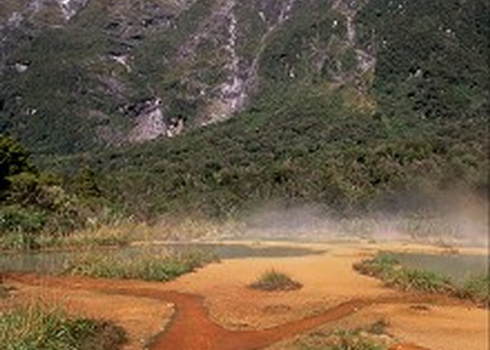
From the hut, a short track leads to a rock bivouac suitable for camping, and to a changing shelter next to the pools. The water boils out of a large, fiery-red hole, spilling along channels into the five pools. The pools are large and deep, offering a range of temperatures. Keep your head above water to avoid catching amoebic meningitis. With the aid of a plastic jar and a sachet of culture, it is possible to make you own yoghurt in the hot pools here!
The track from the hut down toward the river passes a small tent site amongst the scrub before coming to the Copland Bridge. You can cross this sturdy swingbridge to visit Welcome Flat. From the flat (438m) there are good views of the Sierra Range and the peaks at the heads of valleys on the other side of the river. Charlie Douglas described the Sierra Range in 1892,
The Jagged peaks and broken face of the Wakatipu "Remarkables", all that I have read or seen of rugged ridges or mountain, sink into insignificance before this wonderfull sight. A range of broken shattered cliffs, topped by a serrated ridge looking as if some Giant with little skill and a very bad file had attempted to make a saw out of the Mountains.
The track onward to Douglas Rock Hut is easy but less used, crossing several unbridged side-creeks and frequently blocked by windfall. After heavy rain, this track can become impassable and trampers should ensure they have sufficient food and clothing for a longer stay if weather prevents a planned walk out. Three hours is a general timeframe for the walk onwards to Douglas Rock Hut.