Matukituki to Paradise by roads less travelled
- 3 – 6 days one way
- Medium/hard
- Bookings required
A rough, tough crossing from Raspberry Flat (Aspiring Road, Wanaka) to the Earnslaw Burn (Glenorchy-Paradise road) via Shotover Saddle, Lochnagar, Lennox Pass.
This is the latest leg in madpom's East Cape to West Cape traverse.
|
Walking time
|
3 – 6 days |
|---|---|
|
Distance
|
83.4km |
|
Type
|
One way
|
|
Grade
|
Medium/hard
The sidle above Pine Creek (Lochnagar-Snowy) spends ~1km on very steep snowgrass faces above certainly fatal falls - navigates several strata of bluffs. Ice axe, clear visibility and good navigation skills a must. Grades explained
|
|
Bookings
|
Bookings required
Required
This route crosses private Branches Station land. Permission is required from Branches Station. Contact DOC / check online for a number. They are approachable and seem happy to give permission to trampers. Tummelburn & Lochnagar huts belong to Branches.
|
|
Starts
|
Raspberry Flat carpark, Aspiring Road (Matukituki Valley), Wanaka |
|---|---|
|
Ends
|
Earnslaw Burn carpark, Glenorchy-Paradise road |
|
Maps
|
-
|
|
Altitude
|
375m
–
1,953m
Altitude change 1,578m
|
|
Link
|
routeguides.co.nz/trips/876http://routeguides.co.nz/trips/876 |
|---|
Matukituki to Paradise by roads less travelled
A route guide and maps of this track are available here: http://routeguides.co.nz/trips/876
This route crosses private Branches Station land. Permission is required from Branches Station - contact DOC or check online for a number. They are very approachable and seem happy to give permission to trampers. Tummelburn and Lochnagar huts belong to Branches Station and require their permission for use.
11th Jan 2018
It is a long, cruel climb to the Shotover saddle – coming, as it does, after a full day of work under a baking, broiling sun.
The drive up the Aspiring road was bad enough – slowing to a snails pace crawl over 6” corrugations, wheels cresting each wave, one at a time, until the driver finally turns to me and says ‘would you like to drive?!’. With gritted teeth, I make it to 70kph and we glide relatively smoothly from crest to crest with a rattling brrr that sends once-sleeping dogs scurrying onto the passengers lap.
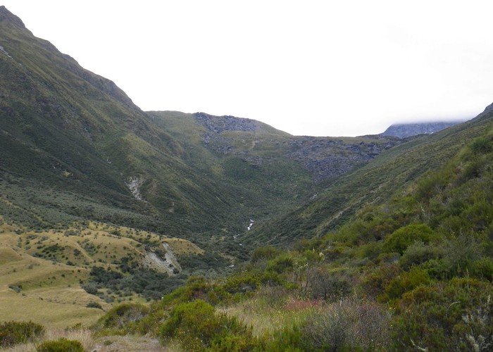
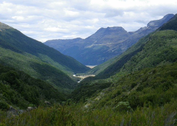
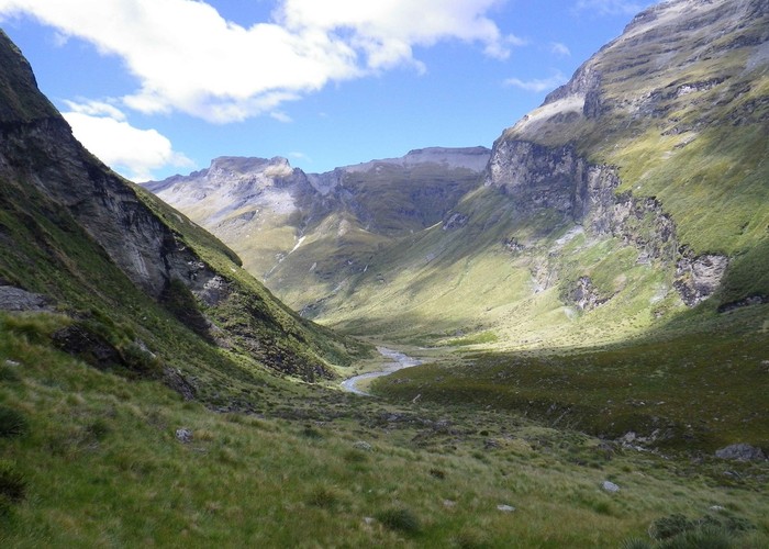
Finally at the Raspberry Flat carpark, wishing dogs and driver a fun trip back down the valley, I swim against the tide. Strolling easily up the Matukituki – passing wave after wave of tourists returning from the Rob Roy track. But beyond the swingbridge, rejoining the old farm track as it winds up the broad valley floor, they are all left behind. Just myself. Just the sound of the creek. Steep valleysides tower over the flat, once-glacial valley floor – saddles visible but peaks hidden by a flat ceiling of cloud.. Green pasture flats cede to dry-brown rougher grazing; the broad valley narrows to a series of flats. Its progress blocked by the river, the farm track zigzags easily up the southern valleyside to sidle, reaching a farm gate. Looking down on more broad flats - Aspiring Hut at their head. Bride’s Veil creek cascades down from the unseen saddle above in a series of falls.
The route guide I’m following states that the route up to Shotover saddle runs parallel to Bride’s Veil, but neglects to state on which side of the creek. Beyond the gate the track descends back to valley flats, and eager not to waste the 80m I have already climbed, I settle to climb the eastern true right side directly from the farm gate (it later turns out the the official route is on the western, true left). Hopping the fence to climb faces above, the ascent is steep, relentless but technically easy. The lower slopes are grazed by sheep. Deep-trodden sheep trails, cut down to bare dirt, lead up the spur east of Bride’s Veil creek. Trails thin out as we climb, tussock replacing grasses – deer, rather than sheep maintaining the route.
My arms are a sheen of sweat; pack adhered to shirt, adhered to back; the constant tickle as beads of moisture trickle down skin beneath clothing. It’s hot. The day has been hot – working hard beneath a relentless sun. Tropical humidity in a brown, baked land. I’ve been drinking and drinking until stomach says ‘no more’ but I’m still dehydrated, fatigued, aching. Climbing, forever climbing; the saddle, that flat ceiling of cloud coming no closer.
A steep scramble just east of the creek, passing the last waterfall visible from the valley floor. Gentler slopes as we approach the basin of the Shotover Saddle – still a 400m climb above – but less cruel. I plod on; the slope becomes a staircase of basins – each one surely containing the tarn at which we intend to camp, each one stubbornly dry. But the campspot is obvious when we reach it: a sheer fault-escarpment, broad slot beneath it running parallel to the face. We sidle west, past the head of Bride’s Veil, find the tarn – nearly dry after months of drought. Small, but comfortable campspots above its eastern tip, tucked low in the gully, sheltered from both northerly and southerly winds. It seems a shame to huddle here, tucked away from those magnificent views up the Matukituki: Hector Col, Mt Aspiring beyond. But in reality I don’t care. All I want is to sleep.
Raspberry Flat to Farm Gate at Bride’s Veil – 1-1.5hrs
Farm Gate to Shotover Saddle tarn 2-4hrs
12th Jan 2018
Cloud has lowered overnight, enveloping us in its grey, damp embrace - though memories linger of waking briefly to a star-speckled sky. I eat muesli, lying flat in my low bivvy tent. Pack awkwardly without leaving its dry confines, until nothing but the tent itself remains to stow. Fold damp fly, still dry inner, leave.
A short scramble takes us above the fault-line basin into a broken landscape beyond. Climbing through a crater-scape of humps and hollows to reach the saddle - where cloud obscures all. The ‘normal route’ down Tyndall Creek is to sidle the eastern valleyside at the height of the saddle, negotiating bands of bluffs until the ridgeline drops to meet you at around 1600m. I opt instead to drop into the head of Tyndall Creek and sidle the face lower down, hoping that the cloud bottoms out before I hit the scrub line.
Tyndall Creek drops abruptly from the saddle into its head basin down a single sheer fall – not even hinted at by the map. Rather than follow it we descend spurs to its west, descending easy scree then moist tussock, dropping below the cloud. We cross Tyndall Creek below the falls, scramble onto brief tussock terraces on its eastern bank at 1250m. Below, the broad shingle gut of the creek cuts through solid, thick scrub, but above 1200m dracophyllum scrub is low and light - the going easy.
The 3km sidle down-valley is straight forward at 1200m. Occasional steep faces and bluffs require a brief climb or descent. Broad deer trails lead promisingly down to basins below, tempting, only to vanish into thick scrub: to be ignored. Soon the ridgeline is visible above, dropping down out of cloud towards us. We scramble up to meet it; stop abruptly - startled to find nothing beyond but 400m of sheer drop to the Tummel Burn far below.
The route follows the tussock ridgeline down as it drops to the forks between Tyndall Creek and the Tummel Burn. Cairns appear, along with the first dracophyllum scrub; a good ground trail forms, leading us down. A single warratah, topped with a lichen-aged white cap sits mid-trail. I ignore it, continue down the good ground trail on the ridgeline, only to encounter thick scrub then sheer bluffs – Tummel Burn Hut clearly visible three hundred almost vertical meters below. Climbing back to the warratah, I pull out the route notes and read up on the correct route. From the warratah we sidle back up-valley, clambering and squirming through thick scrub into the head of a gully, 50m NW of the marker. From here it’s a simple case of clambering down the gully to the Tyndall Creek, far below. The gully starts out as a hard-packed gravel chute, but later on we’re able to scramble out and walk relatively comfortably down through stunted bush on its true left. A final, brief scramble brings us out onto Tyndall Creek, 200m above Junction Flat. Tyndall is narrow and gorged at this point, dropping steeply over a bed of boulders and rock. Several interesting scrambles down waterfalls and over boulders follow, sticking mainly to the left-hand bank. But soon we emerge onto the broad grassy expanse of Junction Flat.
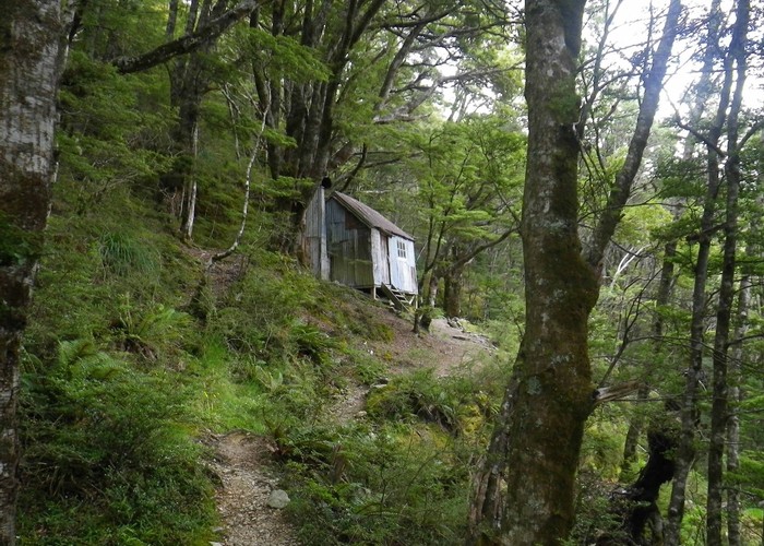
Tummel Burn hut sits 50m away on the western bank, tucked back against the bushy western valleyside. Trip reports I have read berate Tummel Burn as being a near ruin, good maybe to cook in as you camp outside. But the hut is tidy and weathertight: more bivvy than hut – sleeping two on mattresses on the floor, room also for two more; open fire on one wall, well stocked woodshed against the other. Soon the billy has boiled, and I lie comfortable atop the two mattresses, dipping buttered dark German bread into rich beef soup.
Shotover Saddle – Tummel Burn Hut. 3-6hrs. Rough sidle. Careful navigation required for descent to Junction Flat.
It seems a shame to leave the comfort of Tummel Burn. I linger long: dozing, luxuriating in the comfort of soft mattresses, space after a night in cramped tent, hard ground. But Lochnagar beckons, beckons strongly. I rouse myself, peer downvalley through the window at the route ahead, stare into puzzled eyes. A red hind peers back at me from a few meters away – aware that something is not quite right about the hut, but unsure as to what. By the time I open the door, she has gone, melted back into bush and scrub, never there but for a few bent grasses.
Junction Flat provides a few hundred meters of easy walking to the head of the first gorge. Each step raises a cloud of small white butterflies, like kicking though dry, fine powder snow. The start of the once-track is visible on the true left at the end of the flat, but all advice is to ignore it and follow the riverbank downstream. A well trodden deer-trail runs down the eastern bank, sometimes atop the riverbank, sometimes sidling it – straight forward going below faces of ‘man eating scrub’.
Cattle sign litters Pine Creek flat, a reminder that we are on Branches Station, not conservation land. We follow their broad trial downriver, climbing with them to low terraces on the eastern valleyside to meet the start of the farm track. Pine Creek lies opposite, steep tussock faces dropping from the high southern ridgeline we must traverse tomorrow. At the head of the basin a narrow slot canyon hides the falls down which Pine Creek tumbles 700m from the hanging valley above.
The farm track winds its way easily down valley – passing the locked, tidy Hundred Mile Hut with its glittering array of solar panels. We’ve been following a horse for a while, an apparently well fed one. Clouds of black flies rise off each pile of droppings. Bring back theFof butterflies.
Reaching Lake Creek flats, the farm track fords the low, young Shotover to the western bank, feet miraculously staying dry. The old farm track up towards Lochnagar is visible cutting onto terraces on north-western side of the flat, so we head across the brief flats to meet it. The track climbs briefly to sidle the scrubby northern valleyside of Lake Creek for a kilometer or so, before dropping back to the creek, where it ends. An old cage offers a dry crossing of Lake Creek, but its front wheel has seized, and it would be a tiring, hard haul to drag it across the cable with my weight on it. Instead I splash through Lake Creek, bidding farewell to those carefully preserved dry boots. From here the rockfall dam that formed Lochnagar is obvious. A four hundred meter high jumble of rock, boulders, near intact sections of mountainside - blocking the valley 1km upstream. Lake Creek surfaces halfway up its northern side. A boiling, seething white torrent, emerging from nothing to descend the rocky face.
Slopes of soft dry grass lie south of Lake Creek, but no track. We climb gently following roughly the line on the map, gaining perhaps 40m before swaying grass cedes to scrub. The white butterflies have been replaced by orange ones. Equally small, equally profuse to their white cousins – intricate black / orange marbling on their wings. They don’t taste any better. The map shows two tracks heading up the southern face of Lake Creek, and we pick up the lower as it enters the scrub. It starts broad, sidles flat as the creek rises to meet it, before becoming little more than a narrow ground trail as it climbs. The slight breeze that brought comfort in the Shotover fails to reach this enclosed, steep basin. Sticky, hot air diffusing sunlight but not cooling its harsh heat. The climb up the rockfall dam is steady, not steep – but near the end of the day, in this heat, it is sapping. The track receives no maintenance, sweat-soaked body pushing through hot dry scrub, ever climbing. Scrub becomes drier, lower, sparse. The track sidles under a large boulder overhang littered with animal sign – its name emblazened on its wall in time-dulled spraypaint: The Goatel. It takes a few moments to figure out ‘what next?’. Eventually I spot a small opening in the ceiling of the rock biv at its rear. Scramble up rocks, squeeze myself and pack through its confined space to emerge onto the broad flat top of the boulder. Beyond, the steep rockfall face has ended, replaced by a debris-field dotted with low scrub. We climb more gently now, sidling NW towards the northern valleyside, cutting through a large rocky basin, climbing wave after wave of rockfall debris. To our right the conical peak of pt1263 rises 100m sheer above the debris-field – a single pyramid of rock, once part of the ridgeline 700m above, now stranded here amidst the smaller litter of the slip.
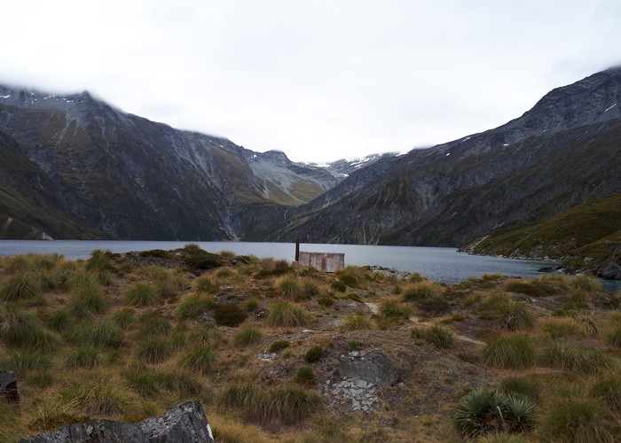
Cresting yet another ridge, Lochnagar comes finally into view; the rusted iron roof of Lochnagar Hut tucked in at its foot, tiny, subtle. Three kilometers of water, trapped between sheer valley walls, waterfalls at its head tumbling white from the head-basin beyond. After the still, hot air of the climb, a gentle breeze blows down the valley: cooling, welcome, but confusing the symmetry of reflected peaks in blue-black water. I stumble the last few hundred meters down to Lochnagar Hut, drop hot dripping pack off weary shoulders. Dive into those cool, welcoming blue waters.

I sit at the hut table drinking more soup. Looking out through the three tall glass panes over water to peaks beyond. Sip the mandatory dram of Royal Lochnagar from the bottle kindly provided. Luxuriate on soft mattresses in the cool of the evening as peaks, water fade to darkness.
Tummel Burn Hut to Lake Creek flats. 1.5-3hrs River route / farm track
Lake Creek flats to Lochnagar Hut. 2-4hrs. Track – overgrown/vague in places.
14th January 2018
I linger long at Lochnagar Hut, luxuriate over a breakfast of bacon, mushrooms, eggs. Delay still longer over strong black coffee, never so good as from that chipped enamel mug. The day has begun to warm when I finally leave – sun clearing tall peaks to north and east to bake the steep faces between Lochnagar and Pine Creek. I cross the lake ‘outlet’ - used only by flood waters with the main flow underground. Climb the spur beyond towards pt1865. The lower faces are scrubby, the spur initially vague and untravelled. But soon the spur becomes more obvious, ground trails converge to provide a good, clear path up its spine. Lochnagar drops slowly away as we climb, the hut becoming ever smaller, soon vanishing amidst the boulderfield. Bluffs appear above, the spur becoming steep, sides sheer. We cut off it to the west, sidle a last scrubby basin into the clear rock-tussock gully beyond. Climb its open floor to the saddle between pt1865 and pt1896. A steady, easy climb.
North of the saddle, snowgrass faces drop steeply towards bluffs and the floor of Pine Creek 800m below. Cloud moves in from the west, wisps appearing round the peaks at the valley head, but not blocking the view to the pass. A good ground trail sidles NW behind pt1896 for 100m to end in confusion amongst bluffs dropping NE from the peak. We poke around a bit, find vantages to get good looks at the ground ahead. A good terrace lies 40m below us, providing unbroken if steep travel to the head basin of Pine Creek. I find a tussock spur just back from the bluffs, dropping steeply through otherwise impassable country to the basin 40m below. A slow, careful descent exposed to long falls below, ice-axe anchoring each step, handholds, footings double checked. A couple of minutes later it’s behind us. Steep snowgrass faces stretch almost unbroken to the head basin of Pine Creek above bluffed country below. Care makes for slow travel, the single kilometer taking nearly 40 minutes, ice-axe doing its job aiding footing, ready to arrest a fall. As ground becomes gentler, approaching pt2000, a flat terrace of gravel appears below us, clear in contour lines on the map. The grassy face we are on climbs, bluffs below becoming taller and impassable as it nears the 2000m peak, but the lower gravel terrace runs clear into the Pine Creek basin above. I nose around for a descent, find one 100m back the way I came. A chopper clatters up the valley, THL colours clear on its belly, tucks beneath the cloud layer barely 50m above the pass as it crosses into Snowy Creek beyond.
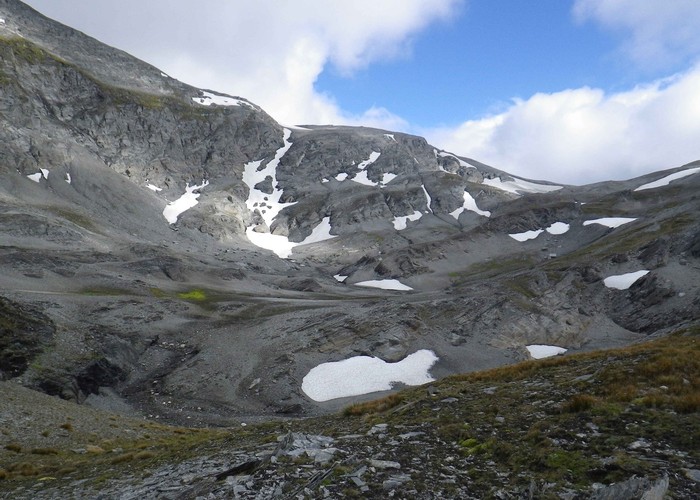
Once on the gravel terrace, travel is easy, ice-axe superfluous. An easy, gentle climb leads into the barren moonscape of the upper basin of Pine Creek. Scree, dirty late-summer snow. Colourless water of the creek, beneath a grey ceiling of cloud.
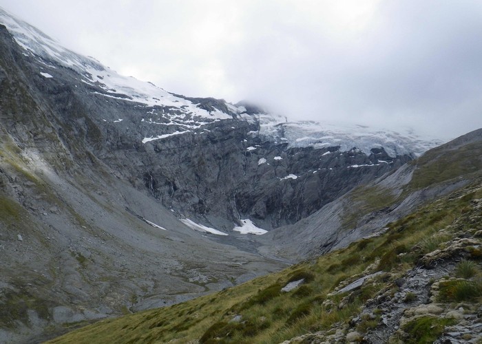
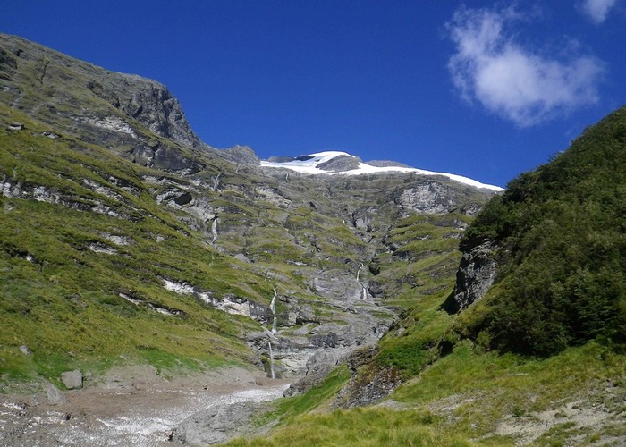
We follow Pine Creek as it swings north, climb the scree basin to the saddle at pt1950; look down on Snowy Creek. The Snowy swings north below us to terminate in a broad cirque beneath high glaciated peaks. Glaciers, icefalls cling to the sheer faces around the curve of the valley head – grey blue ice dropping from grey cloud above. Sheer cliffs at their base falling hundreds of meters to a jumble of broken glacier-debris below. Two more choppers pass low overhead as I walk, swing into the Snowy, clatter – distant specks against the ice-face, as they circle the cirque before heading off down valley to disappear over another saddle to the south.
A cold, bitter wind cuts across the barren rock saddle, and I hurry across, eager to descend west to the shelter of the Snowy; find my way blocked by bluffs. To the south tussock spurs appear to offer good travel to the valley below, but I consult my map and route guide and determine it is the next spur north that I should take. A small creek cuts deeply through terraces just north of the saddle, we scramble across to its northern bank, follow west down the narrow spur beyond – a lone cairn confirming that we are on the right route. Bluffs at 1800m block our way, but are easily passed dropping south towards the creek and sidling back on scree beneath to the spur. Tall rolling tussock returns, and we stumble our way down down through it to reach the broad shingle flats of Snowy Creek. Six more choppers circle the valley as we descend. Once on the valley floor, the choice of descent-route becomes obvious – those ‘good tussock spurs’ to the south terminating in sheer bluffs lower down. The sole viable route: the spur we descended.
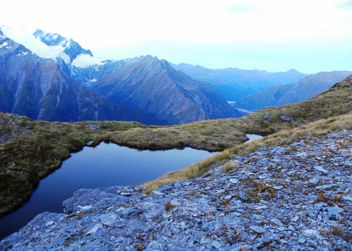
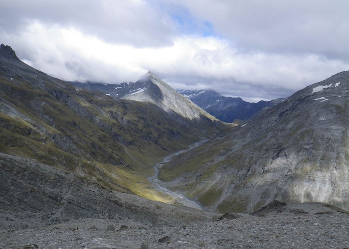
With the spectacular glaciated cirque as its backdrop, the broad moss-and-tussock flats of the upper Snowy would make a wonderful spot to camp and linger – but I settle instead for a lunch of bread and soup. The flat wide valley makes for good travel; I follow the southern bank downstream. Tall peaks on the southern valleyside drop suddenly to the low triple-bite of the Rees Saddle, just as the flats of Snowy Creek end and the river enters a tight gorge. Instead of entering its confines we climb and sidle tussock faces to the nearest of the three saddles; find there a shallow tarn with comfortable but exposed campspots, views down the Snowy and Rees. Fifty meters beyond, the saddle of the Rees-Dart track is marked by orange markers, a circle of walkers enjoying interesting-looking lunches under a once-more sunny sky. I save my remaining dry-bread and peanut butter sandwich until I’m out of sight.
After a steep descent from the saddle, the track down the Rees is surprisingly pleasant. Not the carved motorway I had expected, but a simple foot-worn tramping track winding through moraine and low scrub. Reaching taller scrub the track sidles high, well cut through the vegetation, before dropping back to the valley floor a few hundred meters above Shelter Rock Hut. Shelter Rock is well done, subtle even. A collection of smaller 12-bunk huts tucked into scrub and bush, linked by wooded walkways, rather than the out-of-all-proportion, barn-like monstrosities of these popular tourist routes. A couple of friendly Israelis chat as I prepare yet more soup to go with my bread – not so dry with something to dunk it in!
Lochnagar to Snowy – steep exposed route with prolonged scrambles. 4 hrs
Snowy to Rees Saddle – riverbed route. 1-2 hrs
Rees Saddle to Shelter Rock Hut – track. 1-2 hrs
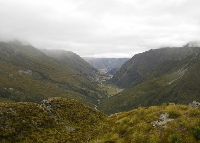
The remaining walk down the Rees to the park boundary feels more like 10kms than the seven it actually is. The track crosses a short bridge to sidle through interesting avalanche country on the western valleyside before reaching the bushedge after about 1.5km From here down, views end and we wind and sidle through tall mature beech for the remainder of the trip, briefly emerging into sunshine only at Slip Flat. Crossing the bridge back to the eastern valleyside we finally emerge onto farmed flats. The temperature has climbed by at least 10 degrees since we left Shelter Rock; the once-pleasant day returning once again to humid, oppressive heat. I wipe the sweat from my brow so often that I start to fantasise about fitting wipers. Reach for my water bottle, only to find both it and its partner yet-again dry. Could that really be the 8th bottle today?
We head down-valley on a farm track through through broad flats of dry whispering grass. The tight beach-clad Hunter Valley joins from the west, and soon after the poled Rees-Dart track swings left off the farm track, headed for the eastern valley side. Bidding it a happy farewell we continue along the farm track, fording the Rees in a low, ankle-deep crossing to the western bank. A low terrace, maybe 20m above the valley floor forms below the western face, dotted with beech and sparse scrub. We angle towards it, climb it, to meet a line of marker poles coming from down-valley. A signpost marks the start of the Earnslaw Track.
Looking from below the face below Kea Basin is a maze of bluffs and bush faces. But the Earnslaw Track zigzags its way between them, up the western face of the Rees through mature beech forest and across old scrubby slip paths. The climb is gentle – so gentle in fact that it feels more zig-zag and less climb, covering the 1km to the hut in over 3km of walking. The DOC sign at the bottom promised 1 hour to the hut – and for the first time in as long as I can remember, the walk takes me as long as DOC promise. Maybe I’m tired at the end of a long day, but it seems a long walk to cover just one kilometer of ground. We curl out of the still, hot gully we’ve been following for a while and swing onto a marshy open terrace with views back up the Rees. Groups of climbers start to pass in the opposite direction. Most barely return a greeting – probably as tired as me after a long, hard day with a few hours left back to their cars. Some stop however and chat. A white bearded fella, I’d guess in his 60’s: greeted the dawn on Earnslaw’s East Peak ... not that there was anything to see with the cloud line at 2000m, well below the summit. Intrigued by my route – more for the peaks I have bypassed on the way than for the walk itself. Others, young, sporting huge packs laden with rope and gear. A long way up to Esquilant Biv lugging that lot.
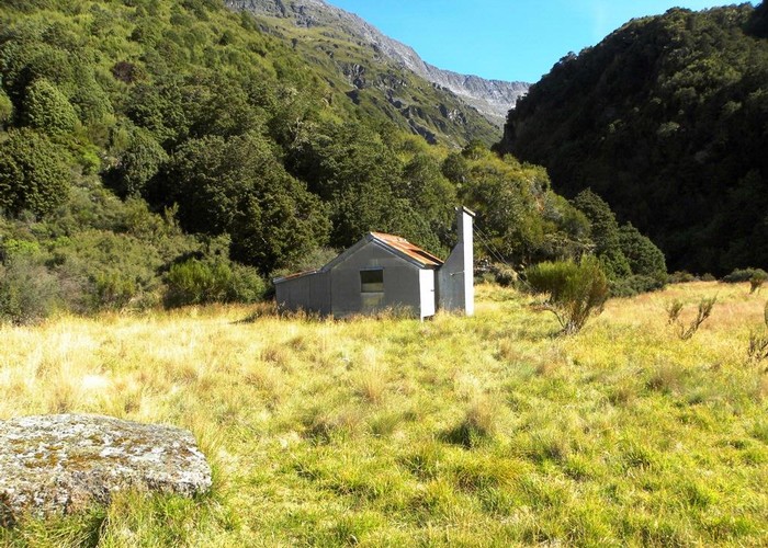
A few more zigzags, clearings, patches of bush – and we’re at Earnslaw Hut. Tucked at the base of low bluffs, shaded but hot in tall mature beech forest - 50m off the main track. It feels more an old musterers’ hut than a climbers one: stamped iron on the walls, hessian sack beds over beech poles, stone-built open fire on one wall. The wooden floor lacking the usual tongue & groove allowing sandflies free passage through it’s gaps. Eager for a drink I nose north from the along a well travelled track, dropping into a small gully, following the tinkling of trickling water. A minimal trickle of water cascades down the mossy bluff-line, more a series of falling droplets than a stream of water. At the base the ice-cool water has carved out a smooth-worn clamshell hollow in the rock, a just-big-enough bathing pool at the end of a hot, sticky day.
As I sit and prepare dinner, several more climbing parties pass on their way up the track. Heavily laden, not pausing to take the one-minute detour to the hut. Climbing to Esquillant in the evening light? A night under canvas at Kea Basin? Planning nights under one of the many rock bivs that dot the route to the summit? As the night closes in, I realise why. The hessian bunks are sagging, constricting, unusable. Lower bunks have been levelled with rough-sawn transverse boards of varying thickness, so uneven that the steps between each are painful even through a sleeping mat. Only the floor remains as an option to sleep in any comfort– a six-bunk hut reduced to space for two on the floor.
Shelter Rock Hut to Earnslaw track junction: 1.5-3 hrs, well maintained tramping track
Earnslaw track junction to Earnslaw Hut, 1-2 hrs, well maintained tramping track. Once crossing of the Rees, could be tough after rain.
15th January 2018
I make an early start from Earnslaw – eager to get my aching body off the hard timber floor – sleeping mat or no. Muesli a poor substitute for the previous day’s bacon and eggs. The track zigzags on from Earnslaw Hut – soon reaching the bushline: Kea Basin tinted copper in the morning light. I cut south off the track to pt1074, pass the first of the many rock bivs, two tents tucked neatly on its soft sandy platform. Looks comfy!
{The north branch of Lennox Creek is low, small. Cutting deep, an impassable sheer sided gorge below Kea Basin, but an easy scramble down brief tussock faces up here on the flats. We sidle south, keeping our 1000m height through mature snow-battered beech. Cross a couple of infrequent avalanche paths, old trees laid rotting flat, replaced already by new growth. A brief band of scrub leads to stark daylight and the southern branch of Lennox Creek. Green grass struggles to establish itself on the banks, all other vegetation swept clear each winter by snow, ice, debris from the mountain above. Lennox Creek is again cut deep into the mountain – steep sides of crumbling rock. But for the first 500m below the base of the falls the gut is filled with old avalanche debris, packed hard and smooth from a summer of freeze-thaw. A simple ten pace walk takes us across the ice to the far bank, up the bare green-grass slopes to the safety of tussock and scrub faces beyond. Even this late in the year it feels not a place to linger.
Terraces lead south from the creek – beech alternating with scrubby tussock. Two creeks drop from Black Peak above, barely 100m apart. We cross both, pick up well worn deer trails climbing the spur south of the second towards bluffs north of Lennox Pass. Cloud covers the peaks of Earnslaw, swirling, reforming – but the easterly sun bakes the faces as we climb. A series of low bluffs guard the entrance to the basin below the pass, we cut between them into the tussock basin, climb - steep - the hard-packed scoured dirt to the pass.
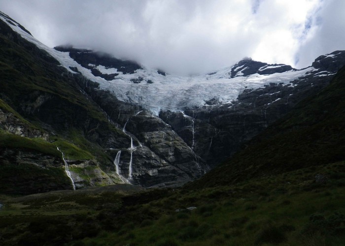
That same bitter wind slices through us as we hit the summit. The massive glaciated cirque at the head of the Earnslaw Burn dominates the view beyond, but I crouch low, scuttle over the pass to sheltered ground beyond. The gut descending to the head basin of Earnslaw Burn is unyielding hard-pack. Another careful descent, each step anchored by ice-axe until we hit more yielding scree below. Even then, the scree more platelets than rocks, eager to skittle one-over the other taking the tramper with them, rather than yield to a boot for an enjoyable scree run. The careful descent thus takes the best part of an hour. Each pause for rest extended by long awe-stricken surveys of the glacier opposite, above. Waterfalls tumble from its base; find fault-lines in the rock below, cut improbable diagonals across the face as they exploit the weakness in the rock. Find their way blocked, finally tumbling again to find more fault-lines below.
Deer trail cut downstream below bluffs at the rear of the fan below Lennox Pass, take us to the river at the head of the top flats. Fire rings show it is a popular place to camp, flattened grass attesting how recent use it has had. And hardly surprising, with that backdrop to be had. I brew more soup in shelter by a side-creek. Find to my dismay that mould has discovered my remaining bread. Enjoy, once more, that view.
A well-worn track leads down the east bank of Earnslaw Burn, unmarked to the bushedge, but easy to follow. A DOC triangle marks where the track enters the beech forest, becomes formal: marked, cut. The rock biv is clearly visible opposite, across Earnslaw Burn – but unwilling to trade sore dry feet for sorer wet ones, I pass up on the visit. Instead I start out down valley in the still, sticky air of the forest; head down what the map shows as a flat-surveyed trackline down the eastern valleyside. Find anything but. The track climbs and falls, sometimes below bluffs, sometimes over slips, often for no visible reason at all. The bush is open, the track clear in the upper reaches, but windfall, slips become more common as we descend. I pass the first of many parties, returning down-valley from a night camped in the head basin. Others ascend, hot, tired, eager to reach their destination. A frenchman, bare-chested, music pumping from his backpack – a curt accented greeting. Couples sitting, enjoying a brief rest from the climb. Two blokes from Southland, out for a rare overnighter. ‘We used to get out every week or two, but then we had kids’, one comments. ‘Not kids with each other’ - the other hurriedly explains. ‘I mean, nothing wrong with it, but we’re not like that’.
The track emerges finally from bush onto hot grassy faces, sidles onto the spur, descends farmland - tall swaying grass, scattered beech, to the main Rees-Dart valley floor. Cuts west along a fenceline to the corner on a farm track where a dozen cars are all that mark the carpark, track start.
Sore-footed, drenched in salt-stinging sweat, sun-baked on this hot valley floor – but happy to have started back on my grand traverse again.