
Having done the North Opuha we were keen to check out the new hut in the South Opuha put in by the McKenzie Alpine Trust. We knew the location for the new hut was different from where the former hut was and every relatively recent map we consulted showed a hut on the true right and an old hut further downstream at the confluence.
We studied public access to the river via Stoneleigh farm. There was a lot of comment and speculation on the Hunting and Fishing forum with not much factual stuff. They did say the river was fairly rough and time-consuming to travel up and the 4WD track would save a lot of time. There was also some griping about the landowner so when we arrived, we called into the station to see if we could get permission to use his track. But there was no one home so we drove on until we got to the first gate and thought it politic to park the car here and walk the whole way in.
Fortunately the farmer came along and very kindly allowed us to use his track as long as we paid him $20. Having no cash, we assured him we’d go to the pub at Kimbell when we came out and get him the money. We followed him along a 4WD track going upstream towards a major confluence. He was meeting his wife and other family who were coming out from staying at their private hut called “Up Yonda” at the end of the 4WD track. Luckily we met her and the others in a broad section of track before it became narrower and tricky. She was as friendly as her husband.
The road was slow-going and greasy so Frank elected to drive just to where it is shown to end on the topomap and we walked from then on to the junction. A hunter was camped by the hut but was sitting in his car reading a hunting magazine to keep up his motivation. He’d set out earlier, pushing his way through wet bush on a rudimentary track that leads up the river to the next confluence where a hut is marked as being on the true left which the farmer had never known to exist. The hunter warned us about the wet scrub on the track but we were keen so set off in misty drizzle after he’d given us an indication where the ford across the river was.
The track was indeed scrubby and didn’t appear to have had any clearing done on it. After 10 minutes we dropped down to the river and were rewarded with the sight of 4 nanny tahr dropping down on the other side. They changed their minds when they saw us. We had to be attentive to stay on the glorified animal trail. At one stage we gave up and had a steep, slightly hairy drop-off down to the river after fruitless followings of various possibilities of markings. Some work needed there if any locals are reading this. On the way Frank flushed out a wallaby.
We got to the next confluence and then really began scratching our heads about what to do next. A couple of poles led up towards the summit of Sugarloaf 800m up the hill on the true right, then ended abruptly. We tried sidling but it was rough and I could see it was going to get very steep ahead so suggested we go back down and try the river. However the river was quite deep and had a bit of current so Frank wasn’t having a bar of it. I was impressed by the size of the several trout that darted away when we entered the river to cross the first section. What to do now? Try going up the true left.
Frank looked at the map and said we’d need to ascend 500m and sidle up valley to drop down to where the hut was marked. So off we set in some scrub which had a bit too much matagouri and spaniard for my taste. There was still fine drizzle so the gloves got wet as I grasped matagouri to avoid being jabbed by speargrasses. After climbing 280m, Frank enquired of me if I enjoyed climbing. This was his way of saying we should now sidle as he could see the terrain would now allow us to commence sidling. When we came to a tiny stream, I thought it was a good idea to collect some water in case we ran out of daylight and needed to camp. We sidled in the rocky scrub- covered heads of several gullies which was a bit time-consuming but never tricky and then dropped down a friendly spur towards where the hut was marked on Frank’s GPS and my recently downloaded mapping software.
Dusk was falling and we couldn’t see the hut through the mist on any of the three little terraces on the other side of the S. Opuha. There was some greenery indicating willows so we crossed and examined each terrace with some pessimism. This was justified when we found the old piles of the former hut site at the northern end of the middle terrace.
We selected a campsite further south in the lee of a willow tree just past the old toilet site which was marked by wire guys and anchors amid boulders but we had to trim a few low branches. The tree sheltered us from the fine mist and the site was excellent. I hung my damp shirt and other items in the willow tree to dry out a bit and cooked on a low escarpment running alongside the terrace right by the tent.
In the morning we looked at the map to see where someone would have put a new hut. The confluence 700m upstream had a bit of a terrace and we decided to go look there. We crossed the river and climbed 100m to avoid a slip on the true left just before the confluence.
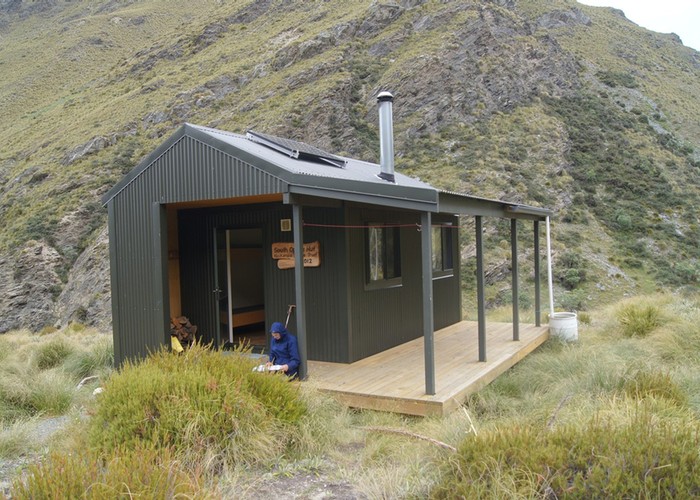
It wasn’t long before we could see the new hut on said terrace. If we’d had visibility the night before we would have seen the hut and been able to spend the night there. We found a place to drop down at the edge of the slip and discovered we were only the second party to have traveled up the river to the hut since it was built 4 years before. Some other keen trampers/hut baggers had come in via the Sherwood Range and the Two Thumb Range on either side of the valley. Frank suggested we could come back via Fox Peak sometime.
We returned to the campsite, packed up and set off back down valley. Frank thought it would be more pleasant if we did the full 500m climb and sidle down valley which proved to be the case. The valley was so full of sign, I quipped it could be called the O’Pooer. We gained height gradually and then just at the highest point we dropped down through tussock and crossed a gully to check out an old musterers' hut far below the end of a 4WD track that comes over the range from the east. Our travel was slowed by felled pines around the hut which was very derelict and not worth the visit but the travel was good from here down to the river and we had avoided the nastiest sections of that track on the true right.
We forded the river and picked up the trail on the other side. I was well and truly sick of the scrub travel and getting a bit tired by the time we arrived at the hunter’s camp. We were pleased to see he had gone out hunting. It was a bit of a grind back up the 4WD track to where Frank had parked the car and we were glad to get there. We drove out over flexinets through farmland, encountering the farmer and his wife spending a lot of time trying to shift some bulls.
Frank dropped me off at the pub to order 2 very nice roast dinners while he doubled back to pay the farmer. It was good to have finally done some tramping in the region and seen the hut. As soon as I could, I went on tramper.co.nz and corrected the erroneous location of the new hut.