Faulkner's Track
Ohinetahi Bush Reserve
- 45 min – 1 hr one way
- Easy/medium
- 45 minutes downhill
- 1 hour uphill
- From Governors Bay, the foot of the track is not marked, but starts at a set of concrete steps near Hyland Brae.
- North Boundary provides an alternative side track, exploring the forested gully beside the track.
- O'Farrells Track no longer connects with Faulkner's Track.
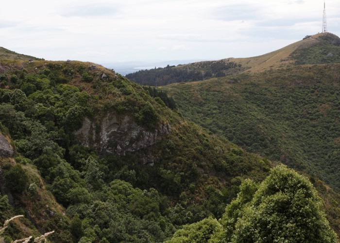
Steep track dropping through bluffs to Governors Bay in the Christchurch Port Hills.
|
Walking time
|
45 min – 1 hr |
|---|---|
|
Distance
|
2.2km |
|
Type
|
One way
|
|
Grade
|
Easy/medium
Crossing steep terrain. Not suitable for young children or anybody sensitive to vertigo. Track can become hidden by grass. Grades explained
|
|
Bookings
|
No bookings — open access
No — open access
|
|
Starts
|
Hoon Hay Scenic Reserve, 5 minutes from car park on Summit Road. |
|---|---|
|
Ends
|
The Terrace, Governors Bay. |
|
Maps
|
NZTopo50-BX24
|
|
Altitude
|
103m
–
452m
Altitude change 349m
|
The Faulkner brothers were Governors Bay farmers, stalwarts of the Summit Road Society. They constructed Monument Hut, and worked on tracks around the Packhorse Hut as well as the hut itself. They drove this track up from Governors Bay, completing it in 1991.
Find the top of Faulkner's Track by parking at Hoon Hay Reserve just past Worsleys Road and climbing the gentle grassy hill to the stile. From here, everything changes.
The rocky track sidles above a steep drop-off to the North Boundary junction, then commences a narrow zigzag downhill, wedged between steep bluffs, with spectacular views out across the harbour. The grasses are thick, obscuring the path and leaving socks full of seeds (hint: wear gaiters).
Ducking briefly into the forest gully, the track picks up the bottom end of the North Boundary Track. From here, the track straightens out, passes the end of the South Boundary Track and wanders along property fencelines before dropping out on the road.
Walking times:
Notes: