Knutzen Track
Waitakere Ranges Regional Park
- 20 min one way
- Easy/medium
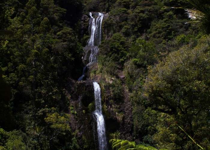
- Kitekite Falls describes the usual circuit into the falls along the Kitekite, Knutzen, and Byers Tracks.
- Kitekite Track leads up the valley from the Glenesk Road car park, meeting both ends of the Knutzen Track.
- Connect Track visits the top of the Falls, and leads to the Winstone Track.
This track visits Kitekite Falls, a highlight of the Waitakere Ranges.
1 member favourited
|
Walking time
|
20 min |
|---|---|
|
Type
|
One way
|
|
Grade
|
Easy/medium
Narrow and rough in parts, with a stream crossing. Grades explained
|
|
Bookings
|
No bookings — open access
No — open access
|
|
Starts
|
Kitekite Track junction near Glenesk Road, Piha. |
|---|---|
|
Ends
|
Kitekite Track junction near Falls. |
|
Maps
|
-
|
|
Altitude
|
30m
–
100m
Altitude change 70m
|
The Knutzen Track does not start at the car park. See Kitekite Falls for a full description.
From the Kitekite Track junction by Glen Esk Stream, the Knutzen Track continues easily to the Falls. A short wooden staircase leads down to the bare rock deck of the Falls. This is a popular spot for swimming.
The track crosses the outflow stream, and sidles into forest. This section is narrow and rough. The track soon meets a wooden platform junction with Kitekite and Connect Tracks.
Connecting tracks
ID 15945
About this track
68 views in the past year (6 per month).