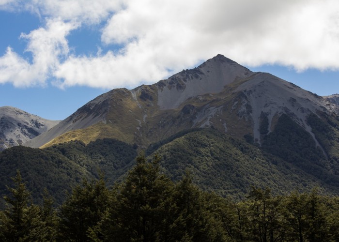
Mount Wall, Craigieburn Range
Craigieburn Forest Park
- 5 hr 30 min return by the same track
- Medium/hard
- Broken River Ski Area locked gate to Palmer Lodge: 1 hour
- Palmer Lodge to Sunny Peak: 45 minutes
- Sunny Peak to head of spur: 40 minutes
- Head of spur to Mount Wall: 30 minutes
Day walk to a summit overlooking the Broken River Ski Area.
|
Walking time
|
1 day
5 hr 30 min
|
|---|---|
|
Distance
|
9.0km |
|
Type
|
Return by the same track
|
|
Grade
|
Medium/hard |
|
Bookings
|
No bookings — open access
No — open access
|
|
Starts
|
Locked gate at Camp Stream on the Broken River Ski Area Road. Turn of SH73 at signs for Broken River Ski Area and Craigieburn Forest Park. |
|---|---|
|
Maps
|
NZTopo50-BW21
|
|
Altitude
|
980m
–
1,884m
Altitude change 904m
|
Mount Wall (1874m) is a prominent peak just off the main ridge of the Craigieburn Range. It overlooks the Broken River valley and the skifield beyond. While the main ridge is relatively smooth and straightforward, the short spur leading to Mount Wall is both rough and crumbly.
During summer months this is a straightforward trip. During winter, snow skills and equipment will be needed.
Turn off the highway and drive past the Craigieburn Camping Area (toilets here) on up the road. Take the sharp right at Jack's Pass, and continue on up to the locked gate at Camp Stream.
Walk up the skifield road under beech forest. After about 30 minutes, the Whiskey Creek Falls Track sets off at a bend. Take this shortcut up past the ticket office and the first lodge. Over the road, a foot track passes further lodges, and climbs stairs above the treeline and onto the tussock basin of the skifield proper.
Follow a 4WD track up past Palmer Lodge, the topmost lodge. Up to the right is Nervous Knob (1820m), while to the left is Sunny Peak (1824m, unlabelled on maps). Head under a rope tow, and on upward toward Sunny Peak. The climb is over tussock, speargrass, and false spaniard, then onto a rocky spur. The final rocky clamber is reasonably straightforward, following the ski area boundary signs to the main ridge.
Up here, there are spectacular views off into the heart of Craigieburn Forest Park to the north and west. The Cass-Lagoon Saddle Track passes by in the valley below. Off to the southwest are the striking glacial hummocks around the northern shore of Lake Coleridge.
The southwest ridge is smooth going up over point 1884 and on to the next high spot at the head of Mount Wall's spur. Perhaps there was once a trig point here: there is a steel pipe driven into the peak.
From here, the spur to Mount Wall heads eastward. It is much rougher than the main ridge. A knob halfway along should be negotiated with care. Mount Wall itself is the abrupt end of the spur, with a small cairn on top.
From Mount Wall, return the way you came. Alternatively, a route dropping southward into the head of Wall Creek and out to Dracophyllum Flat has been mentioned (Brabyn and Bryant, Tramping in the Southern Alps). Dropping off Mount Wall to the southeast, heading over point 1259 and following the creek to Broken River is possible, but involves 45 minutes of scree and tussock followed by about 1.5 hours of unpleasant bush bashing through twiggy, untracked forest.
Walking times: