Pell Stream
- 2 – 3 days loop track with a road section
- Medium
This highly recommended valley not far from the highway west of the Lewis pass, is accessible to most people with a bit of tramping experience and a lot of common sense. The full traverse of the creek described here offers a satisfyingly authentic remote tramping experience.. As a two+ day tramping trip, it crosses a saddle just above the bushline and includes a mixture of wilderness travel both off and on tracks. Pell Stream hut about half-way makes a cozy place to spend the night.
|
Walking time
|
2 – 3 days |
|---|---|
|
Type
|
Loop track with a road section
|
|
Grade
|
Medium
As with any mountain trip in the south island conditions change quickly in winter or with moderate to heavy rainfall. Grades explained
|
|
Bookings
|
No bookings — open access
No — open access
|
|
Starts
|
We started on the St James walkway at the Lewis pass end, walking to Cannibal Gorge hut on the first evening. |
|---|---|
|
Ends
|
Finished at the DOC campground at Marble Hill. |
|
Maps
|
NZTopo50-BT23
NZTopo50-BT22 |
The first hours to Cannibal Gorge hut are on the well developed St James walkway. Staying a night here at the large modern and well used 'Hut' provides a keen contrast to the days to come. The rest of this trip crosses an alpine pass and follows a creek through untracked heavily bushed terrain. A remote tramping experience.

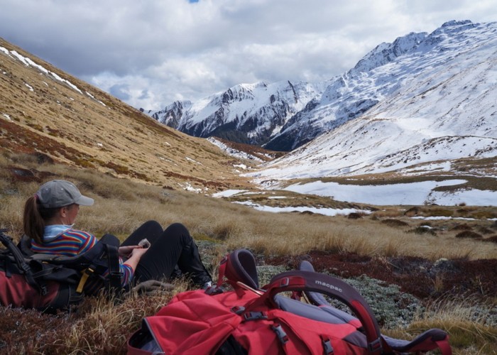
The lowest saddle over the Freyburg range to the head of Pell Stream is obvious on the map, a kilometer NW of the hut. We walked for 10mins on the main track to the larger flat directly below the saddle (BT23 533 146) before following the dry creek up through the bush. A more direct line angling to or from the hut would also be possible.
The dry creek draining the saddle offers good travel to the bushline either in the creek or just up the TR bank. The scrub marked on the map barely exists and several open leads will take you more or less directly to the ridgeline.
Good if somewhat exposed camping is available just below the saddle on the Pell stream side. It is possible to follow the main stream down from here but we found it much easier to sidle round clear of the bushline to the first 'significant' spur on the TL of the valley (Pt 1300) and to follow that down on vague deer trails to where it finishes at the first side creek.
From here to the hut travel is recommended via the beech forest at a level starting at 1000m a.s.l. and keeping to 850m for most of the way. The only obstacles are fallen trees and log-jams.The largest side creek coming in from the right just as the valley starts to open out (BT23 473 143) is a clear indicator you are about 40 min from the hut.
Pell Stream hut is reassuringly obvious from the creek bed, at least it is from just down stream, so check back over your right shoulder as you cross one of the first open flats.
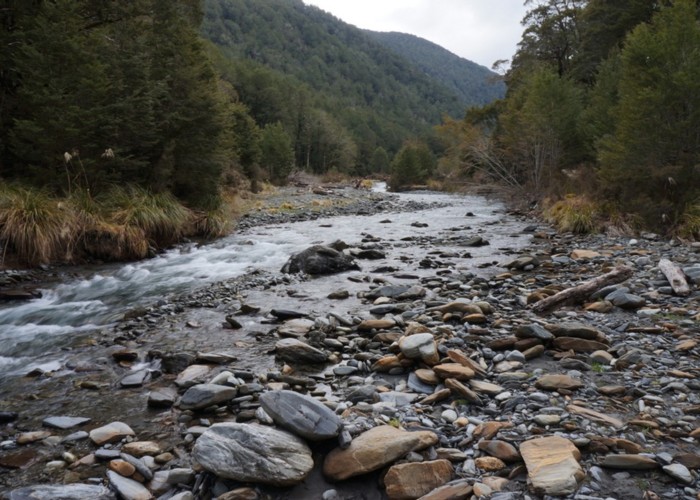
From the hut down there is essentially a marked route all the way down the TL bank, but it is not officially maintained by DOC and in places can be a bit hard to find. Luckily it's most obvious where you need it, so when it looks like easy open travel - use the stream bed and look out on your left for where the track restarts above the two gorge sections.
The first piece of track begins on the left where the flats end (BT23 437 136) and the river closes in with trees above the water on both sides. After first climbing 80m to a terrace covered with magnificent red beech forest, the track passes Pt 760 and eventually drops steeply back to the river. (BT23 423 132) It is also possible to travel downstream in this section on the true left by the river.
A marked route continues just above the creek on the TL but it's often quicker and easier to use the stream bed for the next few km. Just before Gilchrist Stream (BT23 409 131) markers again on the left show the beginning of the second and last climb up onto the terraces.
Apart from the odd windfall the track is now more obvious as it works its way along to join the Alfred river four wheel drive track. From the signpost showing what is the start of the valley for most people, it is a surprisingly pleasant walk out to the Maruia river and a final river crossing to the DOC shelter at Marble Hill campground.
Snow and ice can make the saddle a little harder in winter, and anything more than light rain can make the streams impossible to cross. The Maruia has a bridge just downstream from the campground BUT to get to it from Pell Stream you have to cross the Alfred which can easily be harder to do than the Maruia. From opposite the campground, you may find better crossing points upstream.