
The central North Island Ruahine Range is often considered a poor cousin to the more rugged Tararuas to the south, and the more expansive Kawekas/Kaimanawas to the north. However, many wonderful routes can be followed through the steep-sided valleys and flattish tops of the Ruahines, the northen end of the range in particular offering tramps through some pristine wilderness-like areas.
Over a recent 3-day weekend we revisited a tremendous route to and from Ruahine Corner, which I had not tramped for nearly 20 years. Beginning at Masters Shelter on the eastern (Hawkes Bay) side of the range, the tramp follows a mixture of reasonable to poorly maintained tracks, and some off-track travel, to complete a round loop back to the Shelter. This is a medium-hard tramp, perhaps best tackled over 4 days, but the scenery is equal to the North Island's best for most of the way, particularly if good weather can be dialled up for the tops travel. Prior permission is required to traverse a short section of the route.
Brief notes of the route and some comments are as follows:
- Masters Shelter to Aranga Hut (4 hours): Very steep 800m climb up a reasonable track, followed by an hour of flat ridge travel to this hut on the bushline. Aranga Hut is somewhat dilapitated, and not recommended. However, pitching camp here to end the first day may be a wise option, as the following tops section is very committing once commenced.
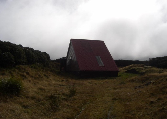
- Aranga Hut to Ruahine Corner Hut (6-7 hours): Rolling tops travel (no track) with great vistas. The route follows the high tops around to high point "U", then drops off down to a bush saddle before climbing up again to an obvious low ridge. The track from the bush saddle to the ridge is poorly maintained, but follawable in daylight. A final stroll leads down the ridge to Ruahine Corner Hut. This can be tiring day. On the edge of the Mangahao Plateau, Ruahine Corner is a special place, with panoramic views of endless tussocks, ridges, the Central Plateau volcanoes and bush. The feeling here is one of splendid isolation, and a pit day (i.e. day off) here to explore and generally enjoy the location is well-advised.
- Ruahine Corner Hut to Ikawatea Hut (4-5 hours): All off-track travel, first across easy golden tussock basins, (again, stunning views) followed by a steep descent down a prominent spur to the Hut deep in the bush valley. Care needs to be taken in picking the route down this spur, which is very steep at the bottom. A competent map-compass navigator in the party is essential. The Hut is a cosy though often chilly 6-bunker. Its location inside the the fork if two rivers could trap a party in foul weather, so be careful with this leg where heavy rain is around.
- Ikawatea Hut to Masters Shelter (8 hours): The marked track from the Hut to the top of No Mans (another 800m climb!) is ostensibly closed, being (now) all on private land. However, it is likely that prior permission can be gained to use this track - contact DOC Hawkes Bay in the first instance. As it is not maintained this track is becoming overgrown, and care is needed to follow its route. Alternative off-track routes (requiring good navigation skills) can be used if permission is not given. Once at No Mans, the route (untracked) follows the very easy and most enjoyable contours of the eastern tops, with stunning views down to the beautiful Hawkes Bay and clear across to Ruapehu etc. The trip finishes with the knee-jarring descent of the first day's 800m climb back to the Shelter.
A truly memorable 3-4 day North Island tramp, with a little bit of everything included to remind you why you so love the hills!