
We drove over on a sunny day to take advantage of the magnificent August weather well west of the main divide. The rain didn’t cease until we’d crossed the Rolleston River bridge upvalley of Otira. By the time we embarked on this climb, it was 3.38pm and the DoC sign said the return trip would take 7 hours so I assumed we wouldn’t be getting to the top.
However with the easy, well maintained and hiked track we were able to get to the summit in 1hr 47mins with Frank talking about an email he needed to send and other work issues. I figured it was probably more pleasant talking about work things than going at a faster pace! We got to a little summit in the thinning forest where there was a mysterious signpost advising us, “150, not out”. The easterly wind which mimics our Canterbury nor’wester had made the track quite dry.
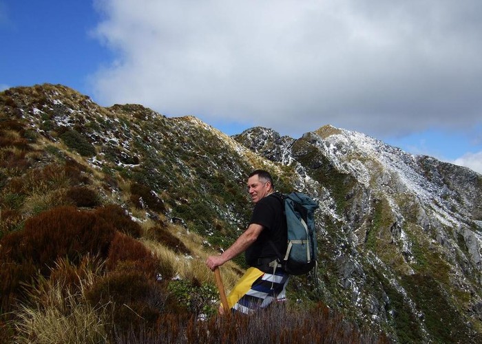
Soon after this we dropped towards a short section of a saddle. I suggested we call it a day and turn back but Frank was happy to go for the summit and descend by torchlight so we carried on. It was good we did because we were now in the scrub zone, indicating the top of the mountain wasn’t far off. We climb up to the spine of Mt Tuhua and headed for the nearby trig. The track was pleasant going amidst dracophyllum, stunted flax and tussocks. A final steep scramble got us to the summit where there were a couple of wooden posts to perch on and take in the expansive views.
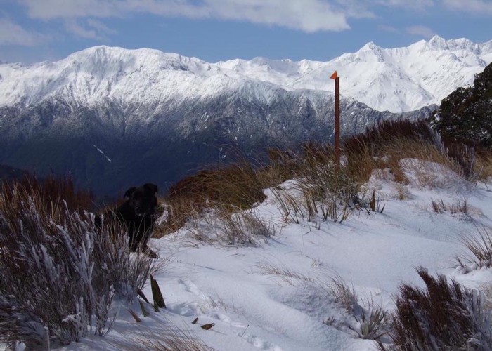
We looked around, identifying peaks and valleys. Nearby was the ridge on Mt Brown where the lovely hut sits. Our quarry for the next day, Turiwhate, was close by. Far off, a white pyramid was reckoned to be Tara Tama after we’d identified Mt Kerr, Mt Griffen and the Razorback Ridge. After 25 minutes of this and Frank taking photo’s in the gathering brilliance of the setting sun we left our vantage point and started to climb down the mountain track again. The nearby snow covered tips of the ranges had begun to turn pink.
The sun finally met the horizon at 5.57pm. The low angle of the sun threw a full orange light on our surroundings. The scrub looked as though it was on fire, particularly with the russet hues of dracophyllum and the weathered tips of the flax enhanced. We paused to take it all in and Frank recorded it for posterity. Then we dropped down to the saddle. We were both hot from layering up at the summit against a moderate easterly. We stripped off and Frank managed to take a second bite of his muesli bar. The headtorches were switched on.
The descent took nearly as long as getting up there. The track is a bit steep at times so care was taken to protect footholds and aging knees! Eventually we were on flatter ground and burst out to the car 1hr and 45mins after we’d left the summit. We drove off to the adjoining campground which was empty except for a friendly Frenchman sleeping in his stationwagon.
I concocted a meal of Kaweka Kiwi Lamb with our own veges, augmented by additional dehy spud (organic!) while Frank selected a sheltered site to pitch the tent by a cluster of small trees. The evening was unbelievably mild for an August night. Eventually we tumbled off to the tent. The bright moon intruded on my sleep. When it disappeared I slept more constantly. In the morning a nearby twittering chorus of finches from the trees punctuated by raucous pukeko squawks got us moving. As the sunlight crept on us and the tent, the Frenchman came over to parley. He’d enjoyed the location so much he’d lingered to climb up to Mt Brown hut in the rain. There, he’d appreciated the little cracker stove to dry his ‘wear’ and gone for a walk around the lake the next day. As a person who eschews the NWC section of Patterson Inlet for its interminable coastal up and downs, his recommendation didn’t appeal to me. Chacun a son gout. He was soon driving off, heading north to the Abel Tasman. Good time of year for that one.
I dried out the tent and we packed up to head off to Turiwhate. We decided time was the essence so didn’t take on the unexplored adventure of following the Old Christchurch Rd.
We arrived at Graham Creek where the track was reputed to start and I reccied for any clues. There were a couple of scraps of cruise or insulation tape on the true left of the creek, just sufficient to lure us along the terrace. I was immediately bitten by some ongaonga. Then I checked out the roadside. An adjoining property had a plaque by a deciduous tree planted to commemorate Prince Charles’s 40th birthday in 1988. Curiously, I heard a voice say, “go away”. Whether this was an omen or a coincidence, I wasn’t sure but kept my thoughts to myself as I wandered back to Frank to report my findings.
We opted for travel on the left bank, encountering a water supply black hose soon after. We followed it down to the stream and then traveled up this in the sun, looking for some form of indication of an old NZFS track starting on the true left. At around the point we expected, we spotted a cairn on a stony terrace. I inspected the bush edge by the cairn, but it was obvious there was no evidence of a track being here. Frank suspected the track was a bit more upstream but I suddenly noticed a smaller cairn a bit downstream and went to explore. Within the bush were plenty of cruise-taped bushes so off we went, scratching our heads about the counter-intuitive siting of a cairn upstream of where the track commenced.
The track was light, initially steep, well-marked and reasonably dry. It got on to an arête high above a stream and climbed until the arête was left to follow the markers through a patch of pungas. Not much to attach markers around here though I noticed a bit of tape on the ground. Had we wandered off the track? We cast about, scratching our heads and wasting time. I wandered further up the slope and found a continuation of markers above some extensive windfall. We carried on after placing a couple of bits of cruise tape I had with me on strategic points. Then the same thing happened, the cruise tape and greyed permolat disappeared. We followed the spur uphill into saplings, finding nothing so retraced our steps to the last marker sighted.
I deviated across a small gully and started up a face to another spur. On the ground were 2 more bits of cruise tape. Frank wasn’t impressed and said we’d wasted too much time and would now have to abandon the climb. I carried on to confirm if this was the way the track was meant to go and soon found some more subtle permolatting on trees. With the remainder of my cruise tape I was able to signal effectively this drastic change of direction. We cleared the vegetation, bending fern fronds down and tossing windfall off the route. The track hadn’t followed any form of handline across the tiny gully but we discovered more dingy permolats in a non-benched line. The mountain would have to wait for another day, when more cruise tape was carried to augment the diminishing line.
After the previous day’s bony descent, the downclimb was quite pleasant as everything was soft underfoot due to a minimum of trampling. We got to the stream and had a initially sunny lunch but I’d failed to reckon on it being well past the zenith so we were soon in the shade looking enviously at the sunny bank on the true right. We were in a very pretty spot by a tiny stream. Then I booted down the silly cairn and built a couple more. I’ve found a very effective design that will catch the eye from afar consists of stacking of hard edged flat stones. Indeed this was the case. Frank also constructed a stable bigger cairn and I tied on a few scraps of fallen cruise tape I’d found along the way to lead people to the start of the track.
We left the scene and carried on down the river, me on the true right and Frank on the true left. Unfortunately I heard a few shots going off on my side so retreated to join Frank on his bank. Travel was pretty clear and fast going. He was puzzled why the track hadn’t run along here right from the road. I guess someone was saving themselves a bit of effort. He reckoned it would be worth spending a bit of time clearing a route along the bank. It would pretty much only involve snipping through a bit of supplejack. As we are so far behind cutting our own track-cutting projects, I didn’t encourage the idea though. We popped out back onto the road and the car and went off to Harrington Creek to do a bit of work on our own track for an hour or so.
I wouldn’t have wanted the weather to have been much hotter. Our track was in good shape and really only needed a rotten collapsed tree removed but we trimmed back the gorse and other small branches. The permolats were starting to get at the limit of their nails so will need replacing asap. We headed off around 5.30pm wondering if there was still much rain in Canterbury.
