
(Tramping hours given here include all stops. I wanted a tramp that allowed sufficient time to take in the stunning skylines. A faster pace is possible but, for us, not desirable. Positional references are NZTM2000 grid, WGS84 datum.)
Feeling fit and keen after a successful 9-day tramp (St Arnaud - Lewis Pass) we set off from Lake Sylvan car-park at 0830, our packs freshly weighted with 8 days food. This was to be a leisurely stroll with plenty of time built in for adverse weather – or side trips if (unlikely as it seemed) we had great weather for this tramp too! The forecast was good - could we hope for another 8 days of blue sky?
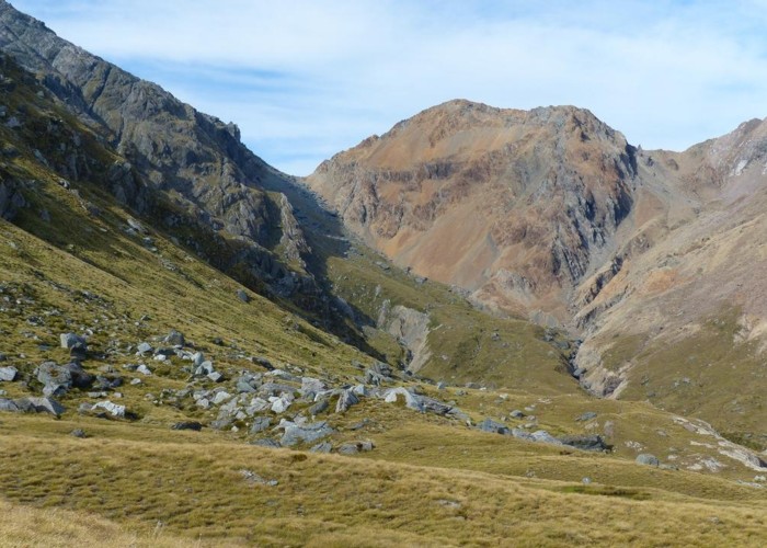
Day 1 : 14km 7hrs Lake Sylvan carpark – Beansburn flats (1226262 5048710)
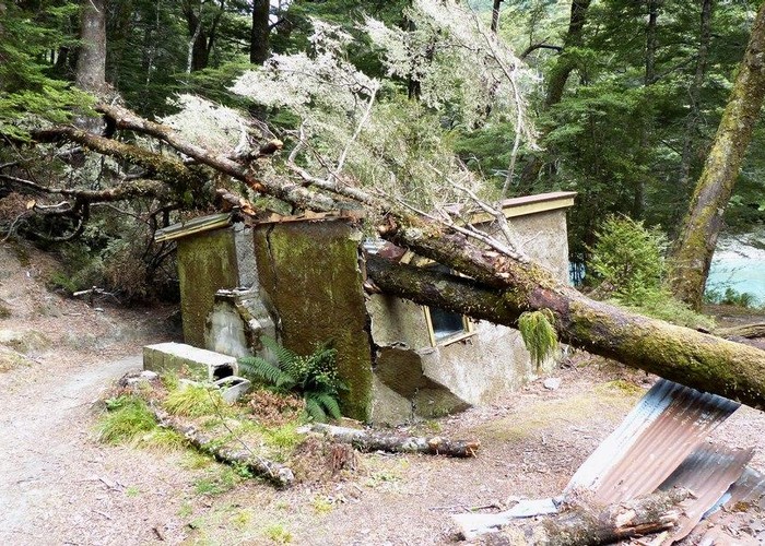
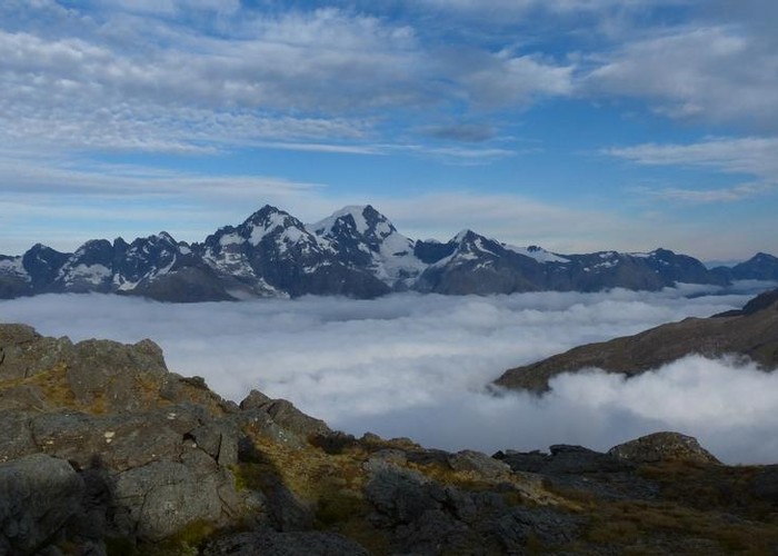
The initial track through open beech forest would be quite boggy in wet conditions but, for us, was bone dry and gentle underfoot. The morning was overcast and cool but not threatening rain and by late morning blue sky predominated. After edging the east side of the lake and a gradual climb (with a few sharp pinches) to the saddle above the Rockburn, a steep short descent brought us to the somewhat compromised Rockburn Hut. Not one of the more aesthetic huts, the tree through the roof does not encourage one to linger. We crossed the Rockburn at the hut and continued up the Dart River’s grassy flats on the true right (TR). Soon I could see, so close, the saddle in the Beansburn behind which was our intended campsite – at this pace we’d be there for a late lunch!
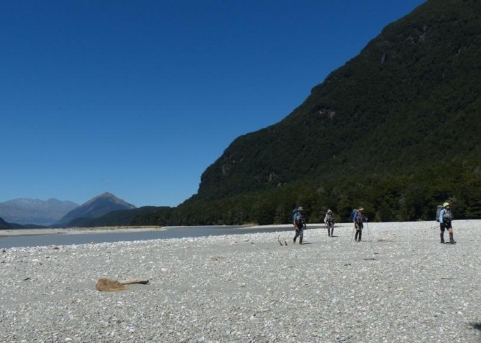
The Dart was low (unlike 5 weeks before when it was running bank to bank) and we came within 2km of the Beansburn confluence before being forced into the bush on the TR. Although we followed a track most of the way, progress was slowed dramatically – some recent bank collapse requiring careful negotiation. Waving hello to a couple of jetboat operators, we crossed the Beansburn (knee-deep) at the confluence for a late lunch (1330) on the burn’s TL.
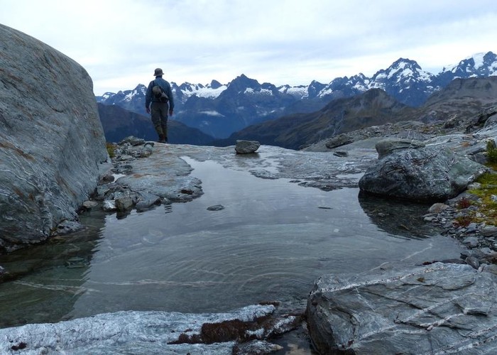
Past the toilet and into the forest, the track is obvious and starts with a steady climb through pleasant beech, ferns and mosses accompanied by sounds of a rushing Beansburn to our left. A good break at the bridge which crosses to the TR preceded a stiff climb to the saddle I’d seen some 3 hours earlier from the Dart. Not much breeze through here and the sweat was running freely now. After a sharp descent to the flats, we decided to look for a campsite at the northern edge and settled on the grass beside the river. Arriving at 1530, we had plenty of time to wonder at the 2 paragliders high above the eastern ridge and to feed the voracious sandflies – how do ultralight hikers survive with just a tarp? For our own protection, we retired to tents early.
Day 2 : 9km 6hrs to Beansburn Biv
Although we had what sounded like rain on the tent (actually it was sandflies desperate for blood) we awoke to a beautiful morning, mist receding to reveal a deep blue sky. Just 9km today, a gradual climb up the valley with a short steeper grade before the flats in front of the Biv – a 400m elevation gain, enough (hopefully) to leave the sandflies behind.
Mostly through forest, crossing numerous avalanche chutes, a well defined track eventually leads back into the river about 2km below the Biv. From here, after a short boulder hop, it’s largely untracked low scrub until the grassy flats. It’s easier to follow the curve of the riverbank rather than strike a direct line to the Biv.
The Bivvy certainly has several well protected chambers (and some less so) but I still find a tent more salubrious ! At 900m, the sandflies are muted but still capable of making their presence felt. Another afternoon at leisure; warm day, brief cold dips in the river, a few brews.
Day 3 : 4.5km 4.5hrs to Fohn Lakes (side trip to Sunset Peak 3hrs)
We had a spare ‘weather day’ and the plan saw us camped at Fohn Lake for 2 nights with a day trip to the surrounding peaks. But, as I expected to hit the lake before lunch, maybe a side-trip to Sunset Peak in the afternoon would suffice and allow us to get a day ahead of schedule - and so it transpired.
We set off from the Biv and crossed to the TL. Following a track and cairns to the obvious saddle upstream, we then descended to a dry branch of the river and followed this up to it’s start, crossing back to the TR 200m before the obvious gut which is the starting point of the climb to Fohn Pass.
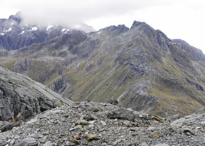
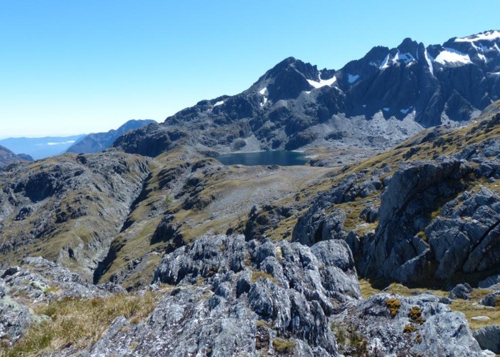
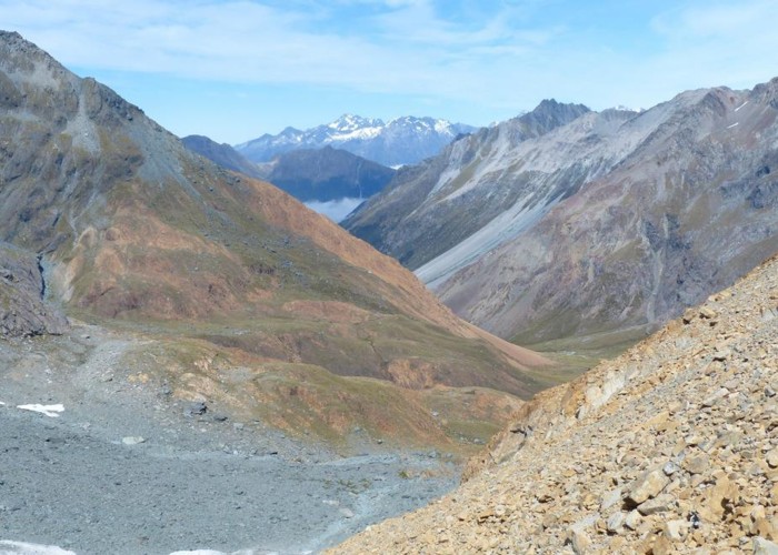
For a short distance, we pushed up the gut then out onto a shallow spur, climbing steeply through the snow-grass. At the 1320m contour, we sidled to the W a little way before resuming the climb directly to the Pass. It’s not a difficult climb although, in wet conditions, a descent would need care. As the gradient lessens, boulders and then scree lead to the Pass with views down the Beansburn all the way to Lake Wakatipu.
We began to descend from the Pass and had to climb steeply to regain a better level to sidle, first across and then down, to Fohn Lake. Better would have been to immediately climb out of the Pass and negotiate a short way to the NE to an obvious 20m wide gully. We followed this down and across to the lake.
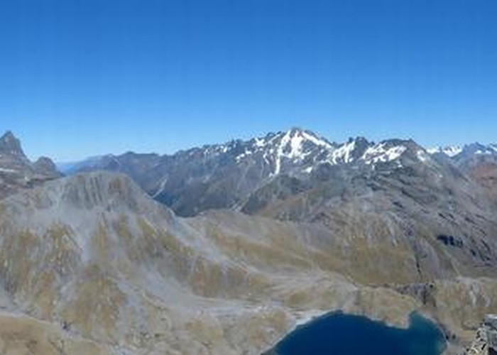
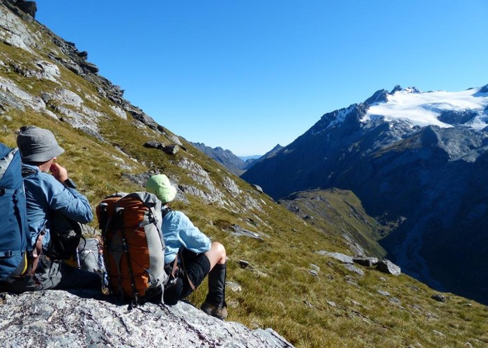
As anticipated we arrived at this idyllic campsite in good time and, after lunch, set off to Sunset Peak, towering 300m above us. What a pleasure to be climbing without packs - we flew across scree and leapt up boulders, hitting the summit in an hour. Stunning – puts the wow in panorama. Seemingly perched on top of the world, we gazed down on the lakes and our tents, across to the Merkl Glacier and Mallory, Irvine and Terminal Peaks, Olivine and Hollyford Valleys and out to the West Coast and the Tasman sea.
Day 4 : 10km 7.5hrs to Hidden Falls Creek (1219355 5053409)
This day was a bit of an unknown. My research indicated a relatively straight-forward 10km but for one group some years ago finding it a real challenge, arriving at camp after dark and completely shattered. So, we set off in good time, climbing out of the lake and then down the ridge on the TR of the outlet, curving around to the right and down. Picking up cairns and an obvious track, we were down on the Olivine Ledge in an hour. We followed a track until we’d crossed the outlet and then generally struck out across the ledge towards the 1200m highpoint. Care is needed here as deep holes and gashes (2m and more) are hidden by snow grass – a broken leg or torn medial ligament easily achieved with a misplaced step.
Less than 2 hours to the base of the climb to Fiery Col and an hour to the top, we encountered the first of 4 groups, highlighting the increasing popularity of this tramp. A good thing we didn’t have 2 nights at Fohn Lakes as we would have been sharing with an additional 7 tents – plenty of room, to be sure, but shattering the sense of peace and serenity of that spot.
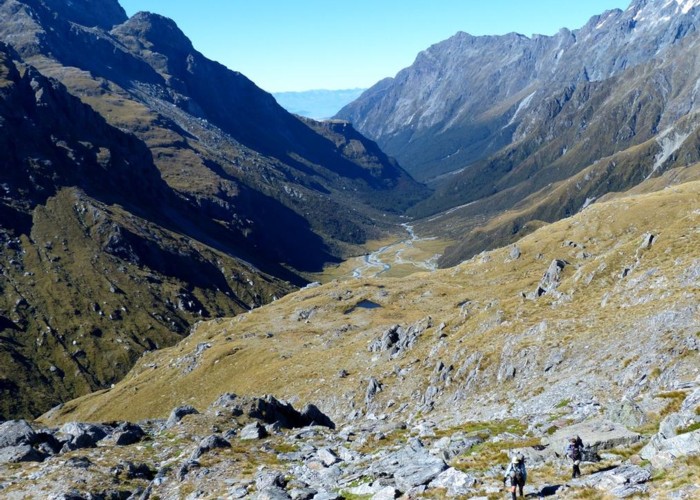
Unexpectedly, the descent from Fiery Col was cairned all the way to Cow Saddle and generally, after a simple and direct scree descent, stuck close to the TL of the huge gut (obvious from map and in-situ). No tricky bluffs to negotiate, we were down the 530m in an hour.
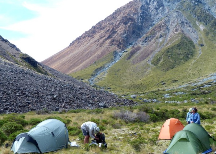
Across the saddle and down Hidden Falls Creek (HFCk), initially on the TL, the going was easier on boulders than grass. Supposedly, there is a good campsite at the treeline on the TL (830m contour) – it’s rubbish! Big enough for 2 small tents, the surface is rocky and uncomfortable. Better is immediately opposite on the TR – plenty of space and a comfortable grass surface, it’s only limitation that it’s a little exposed (one thing I didn’t realise was that HFCk is largely underground until near the 700m contour – although there are a few pools here and there). However, an hour downstream and 400m beyond where the track crosses to the TL, is a wide and comfortable grass flat – better that either 830m campsites.
Day 5 : 4.5km 3.5hrs to Park Pass (side trip to Park Pas Glacier 3hrs)
Another gentle night, awakening to mist in the lower valley, we were up and away without rush. Initially a track on the TR, we dropped into the boulder-filled river rather than negotiating the steeper scree slopes above. Travel was quick and we pulled out on the TR just above where the track crosses back to the TL. In the beech and following an obvious (mostly) track now, we motored through the expansive campsite and down to the creek just upstream of the climb to Park Pass. Although looked-for, we saw no marker here (other than 2 bits of pink tape well in from the river) and were a little confused by a Y-junction in from the river – both branches looking equally well-used. We took the right branch and were immediately climbing (I assume the left branch would have joined in along the way). Very steep and with frequent short stops, the perspiration was again flowing freely. With occasional views of the lower reaches of HFCk and plenty of tree roots to give hand-purchase to assist our efforts, we attained a flat section about 2/3 of the way up – welcome relief but short-lived.
Finally to the treeline, there is still quite a climb but at least now a breeze is drying the sweat. On gaining the saddle, we dropped behind a low rise, sheltering from the now cold wind keening across Park Pass. We had a decision to make!
From Park Pass, the standard 5 Passes tramp heads down the Rockburn, over Sugarloaf Pass and down to the Routeburn. This was our bad-weather alternative. Our plan climbs to Lake Nerine, sidles to North Col and descends the Nth Routeburn. However, I had expected to get an update on snow/ice in the gut on the south side of North Col (often persistent throughout the year). Could we descend without crampons and ice-axe? The weather had been warm and dry but being blocked at Nth Col would not leave enough time for backtracking and exit via Sugarloaf. What to do? Risk it or be safe?
I’d just explained the options to everyone when a group of 4 appeared over the top of the tarn – could only have come from Nth Col ! Yes, was their advice, snow easily avoided – so decision made ! We would camp at Park Pass and do a side trip to the glacier 500m above. Tomorrow to Lake Nerine as originally planned.
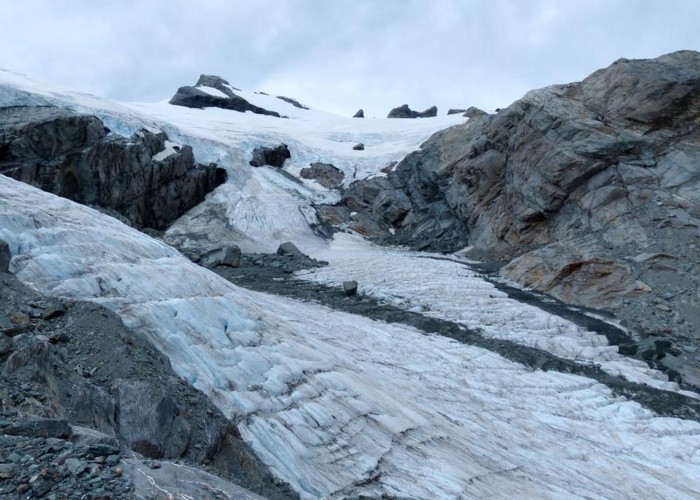
Well worth the effort, the climb to the Park Pass Glacier reveals stunning vistas, crevasses, terminal lake and bergs, moraines - and no queuing tourist hordes as seen on the West Coast.
Day 6 : 4.5km 4hrs to Lake Nerine
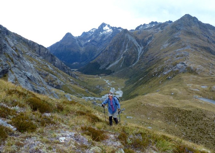
Another short day but some interesting terrain to negotiate. Climbing away from the Pass, along a good footpad, we reach the cairned point where we leave the ridge and begin the rising traverse towards Lake Nerine. The snow-grass sidle certainly has a threateningly steep slide all the way to the Rockburn floor but only in snow or very wet conditions would that be a risk. Soon enough the track is climbing (I startled a rabbit and could have grabbed it as it struggled to gain the next level – if my hands had not been occupied in hauling me up to the same point).
Into the head of the gully and, still following cairns, around to the left, we climbed above 2 unnamed tarns and paused to drink in the views across to the glacier we had wandered just yesterday. On and up now to the final ridge above Lake Nerine, we elected for the shorter direct route, rather than down and across to the tarn outlet then up, to the saddle.
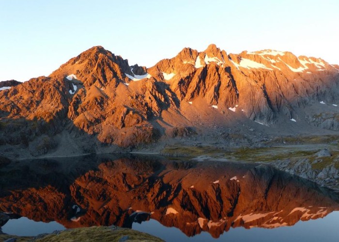
The line we took down to Lake Nerine followed the base of the left-hand wall but just about any route down (without snow) would be as good – it’s steep but the rock is very grippy. We skirted a large tarn and climbed the final rise to survey Lake Nerine – very impressive. Spoiled for campsites, we decided to set our tents at the water’s edge on the somewhat exposed north side, the fine scree providing a comfortable surface.
Although the wind picked up during the night, the only concern was a rock slide crashing into the lake. With a full moon, I nervously scanned the surface for any wave that might swamp us but, fortunately, none eventuated. Lesson learned, though – don’t camp at the water’s edge.
A short side trip to the Nerine outflow gave us an eagle’s view of Theatre Flat, 750m below.
Day 7 : 11km 7hrs to Lower Nth Routeburn Flats (1221057 5037369)
Our last full day dawned cool and cloudy, with patches of blue sky and a freshening NW breeze. We climbed out of the Nerine basin and were confronted with a jumble of bus-sized boulders – not much of a track here. We had decided to try the slower route, staying high and descending onto North Col. The easier route is heads lower but involves more up and down.
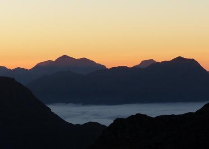
We contoured roughly at the 1600m level, a little concerned that we might encounter bluffs that would require backtracking and descent. However, we managed to pick our way through and descended onto the Col and the shelter of a house-sized rock - the cold wind having gained a penetrating quality. Visible as we sidled, thick cloud filling the Hollyford Valley would have given a very different sense of the weather to anyone tramping there.
Now the descent of the North Routeburn – as advised, the snow in the initial km easily avoided. Steep but not difficult, we soon picked up a track and cairns leading the way down. We did lose the track around the 900m level but found it again soon after. From the 870m contour, the track is obvious and marked through to the Routeburn Flats Hut.
In sight of the hut, we camped on the edge of the trees, beside the river, surprised at the lack of ferocity of the sandflies.
Day 8 : 8km 2.5hrs to Routeburn Shelter
The final morning dawned and we were glad to pack dry tents. The lack of rain in previous weeks allowed up to cross the Routeburn maintaining dry feet and we hit the super-highway that is the Routeburn Track. Passing a plethora of walkers wafting scented soap and even perfume, we were back in civilisation and made the Shelter in good time. Another wonderful adventure concluded.
