
Although regularly spaced tracks retreat onto the flat, warm clothing should be carried. The Port Hills are popular for a multitude of recreational activities. Walking, running, and mountain biking are common. But climbers make use of the volcanic outcrops (dikes), hang gliders drop from the bluffs, and 4WD vehicles, motor cycles, and horse parties use the legal roads. Since many tracks are multiple use, walkers should take care.
Harry Ell was the motivating force for the creation of the Summit Road and the Port Hills reserves. He also planned a series of resthouses along the track. The striking Gothic stone Sign of the Takahe, used today as a restaurant and tearooms, and the smaller Sign of the Kiwi, doubling as home of the Port Hills ranger and refreshment stop, are the most well-known of these. The Sign of the Bellbird also stands further to the south. Destroyed during the Second World War (by vandals), it has been rebuilt as a shelter. The last of the resthouses is Packhorse Hut, or the Sign of the Packhorse, at Kaituna Pass. This hut is located beyond the end of the Summit Road, which was never completed, and is available for overnight accommodation by walking in from the Kaituna Valley Road. By the way, walkers are very unlikely to see kiwi, takahe, or packhorses in the area. You may well hear bellbirds though.
The Crater Rim Walkway extends along the curve of the Port Hills between Coopers Knob in the south and Evans Pass in the northeast, roughly following the course of the Summit Road. Also part of the walkway is the track leading from the hill suburb of Cashmere onto the summit ridge at the Sign of the Kiwi. This area is popular with walkers, and a common departure point along the crater rim tracks. As these are usually walked in sections and easily in either direction, they will be described here as two tracks radiating from the Sign of the Kiwi.
Access
Numerous tracks lead along spurs from the flats of suburban Christchurch to the Summit Road and the walkway. These tracks provide convenient access and allow for a variety of walking options. Some of these tracks, which are described here, are shared with mountain bikers or are legal roads. There is, of course, also easy vehicle access via the Summit Road. A city bus runs as far as the Sign of the Takahe, but none runs up to the Summit Road itself. The Mount Cavendish Gondola climbs to the walkway in the vicinity of the Bridle Path. Its base station on Bridle Path Road is also visited by city bus.
Crater Rim Walkway
Sign of the Takahe-Sign of the Kiwi (H. G. Ell Track): ¾ hr, very easy.
From the complicated intersection at the Sign of the Takahe on the corner of Hackthorne and Dyers Pass Roads, follow Victoria Park Road as the narrow grass wedge of the park widens. After a few minutes a small sign indicates a gap in the trees to the right. This is the H. G. Ell Track. Wandering pleasantly through young native forest, the track soon approaches Dyers Pass Road. It follows alongside this winding road through mixed native / exotic forest and grassland in a gentle climb to the Summit Road. This smooth, busy track is popular with dog owners and runners. Later crossing Victoria Park Road, the path comes out on the Summit Road at the Dyers Pass intersection by the Sign of the Kiwi. Dyers Pass Road drops into Lyttelton from here. The Summit Road departs to the southwest and, bending around Sugarloaf, to the north.
Sign of the Kiwi-Sign of the Bellbird: 1 hr 5 min, easy.
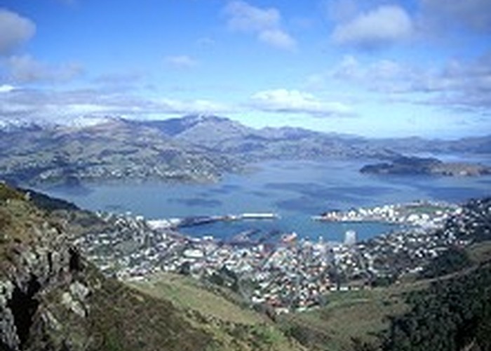
From the Sign of the Kiwi, which sells drinks, food, and souvenirs, and has toilet facilities, the walkway begins beside Dyers Pass Road. Facing Lyttelton Harbour, it climbs easily into Coronation Hill Reserve through gorse and broom scrub. The long jetty of Governors Bay far below is a distinctive feature. At a car park (0:20), the walkway crosses the Summit Road, and follows alongside it as far as Worsleys Road (0:30). Here it crosses the Summit Road again, entering the pleasant tussock farmland of Hoon Hay Park, with scattered native trees and tufts of New Zealand flax, and views across the city. The easy sidle drops to a car park at the foot of Hoon Hay Park (0:45). Another car park opposite the end of Kennedys Bush Road, a legal road used as a walking track, is nearby (0:55). Above the car park, the walkway leads around the city side of Mount Ada, with views into Lake Ellesmere ahead, and patches of light bush around the track (1:00). Alternatively, Ella's Track branches off the walkway above the Kennedys Bush Road car park and leads around the eastern flank of Mount Ada through light bush. This 20 min track offers good views over Lyttelton Harbour, with Governors Bay and the Head of the Bay below. The tracks merge again on the far side of Mount Ada, where the domed top of Cass Peak is obvious ahead. It is another 5 min to the saddle car park between Cass Peak and Mount Ada. The Sign of the Bellbird is located in a clearing sprinkled with kowhai trees just below the road, where the remains of the original building are still visible behind the reconstructed shelter. Beneath the shelter, a track leads down to Kennedys Bush, a pleasant, light forest dominated by mahoe and kanuka. There are, indeed, bellbirds here.
Sign of the Bellbird-Coopers Knob Scenic Reserve: 1½ hr, easy.
Beyond here the walkway passes Cass Peak and the Cass Peak Scenic Reserve, with its montane forest. The end of the walkway is at Coopers Knob Scenic Reserve on the Summit Road, before Coopers Knob itself.
Sign of the Kiwi-Witch Hill: 1½ hr, easy.
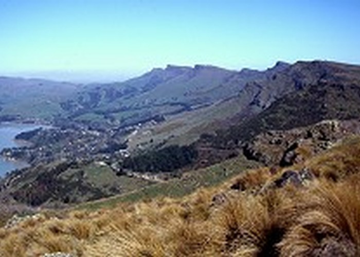
Across the road from the Sign of the Kiwi, the walkway follows Mitchells Track around the Lyttelton side of Sugarloaf through the native bush of Sugarloaf Scenic Reserve. Two other tracks provide alternative routes around Sugarloaf: Gilpins Track provides a higher sidle than Mitchells Track, and Cedrics Track (½ to Bowenvale car park) climbs around the city side, visiting the Sugarloaf car park. Perched atop the 496m Sugarloaf, the 120m television transmission mast is visible on the skyline throughout Christchurch. Dropping easily to a car park at the head of the Bowenvale Valley (0:30), the walkway follows an old stone wall and climbs gently into the exotic forest shade of Scott Recreation Reserve. The walkway returns to the road at a bend beneath Mount Vernon. The tussock slopes of this hill are climbed easily on a zigzag track, with panoramic views of the city, Lyttelton Harbour, and the summit ridge, including Witch Hill and Rapaki Rock to the north (1:00).
A relatively long drop off the northern face of Mount Vernon leads to the car park at the head of the Rapaki Track. Rapaki Rock sits above the car park as a long inverted crescent. It is popular with climbers. Beyond is Witch Hill, upon the summit of which is set a stone monument from the First World War. The walkway skirts its western side.
Witch Hill-Bridle Path: 1¾ hr, easy.
Climbing past the rocky outcrops of the Tors, the walkway drops down to the Bridle Path and its roadside shelter.
Bridle Path-Evans Pass: 2 hr, easy.
Beyond the Bridle Path, the walkway leads onto Mount Cavendish and past the new Gondola buildings. There are various facilities here, but entry is by fee. Sidling around the south side of Mount Pleasant, the walkway passes some World War II gun emplacements and drops to Evans Pass. Here the Summit Road, which leads on to Godley Head, intersects the Evans Pass Road, which drops to Sumner in the northeast, and Sumner Road, which drops to Lyttelton in the south.
Rapaki Track: ½ hr, very easy
This legal road climbs very gently on a long spur from the suburb of Murray Aynsley through farmland to the Summit Road at Witch Hill Scenic Reserve. The wide track is open to all forms of transport, although mountain bikers dominate. The track begins at the Rapaki Road end car park off Centaurus Road. The Huntsbury city bus provides public transport along Centaurus Road.