Only another 400 metres higher is the fine peak of Mt. Angelus (2075m). The most spectacular hiking access to the lake, hut and mountain is along the Robert Ridge - a consistently high, sometimes narrow and usually beautiful route. There are great views into the basins above the Travers Valley and alpine herbfields for budding botanists.
The high altitude (up to 1600 metres) means that this area is subject to bad weather (including snow) at any time of the year. The steep slopes to either side are prone to avalanches in winter. This is a popular area even in winter with ski-tourers on the ridge and frozen lake and climbers tackling snow and ice on Mt. Angelus.
When starting this walk you have a few choices:
- Stay in St. Arnaud overnight to allow a full days walking along the ridge.
- Head straight up the ridge after travelling to the park (unless you are a local this means starting around noon and a late finish at the hut). Good for the fit or those in a hurry.
- Go up to Bushline Hut on the first day - a leisurely way to fill in an afternoon.
The trip can be compressed into 2 days but I suggest that you break the first long day (up to 9 hours) with a stay at Bushline Hut.
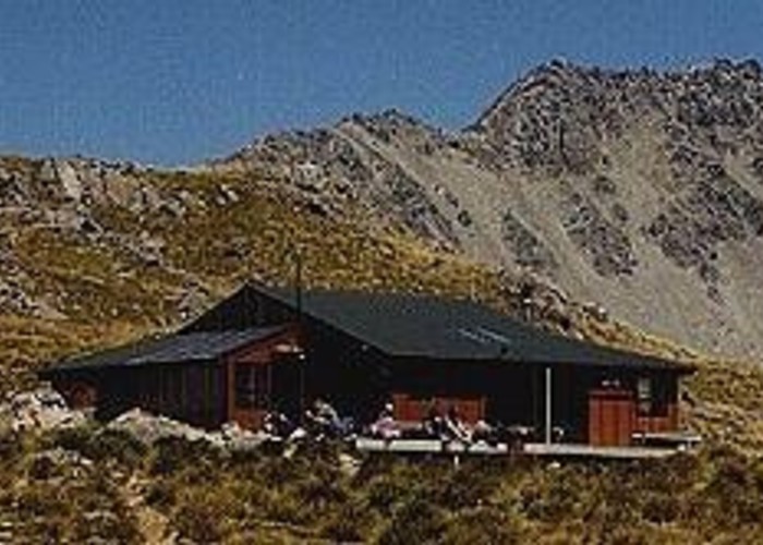
Be aware that Angelus Hut can get full very easily, especially during holiday periods. Don't expect to be alone at the hut and large groups should carry tents.
Up to Bushline Hut
The day starts at the Mt. Robert carpark which is at an airy 860 metres. From St. Arnaud, drive west for 3 kilometres and turn left at the well-signposted junction. The gravel road skirts the lake shore and crosses over the birth of the boisterous Buller River. Another 1.5 kilometres brings the start of the Lakeside Track as the road begins to climb in earnest through beech forest. There is a small carpark and helicopter landing pad (for flights up to the skifield) just before the top carpark.
Paddy's Track departs at the bottom carpark for a traverse of Mt. Robert's eroded north slopes before climbing up to Bushline Hut about 3 hours away. This is a nice exit route from the hut but means extra effort if you want to go up and visit the skifield on the way up to the hut. If you are walking all the way from or to St. Arnaud then some travel along the gravel road can be avoided by following the Lakeside Track which has a branch track joining onto Paddy's Track.
Admire the fine views from the Mt. Robert carpark and then set off along the Pinchgut Track. A rising traverse through mature beech forest soon brings the foot of the massive zigzags leading up a ridge to the summit. Take special note of the sign just before the track emerges onto grassy slopes. Early settlers burnt the forest cover on the north face of Mt. Robert. This has lead to massive erosion that is just started to stabilise - keep to the track!
There are lots of zigzags as you climb up the open slopes. The sidles to the east give glimpses into the erosion gully while the western sidles get frustratingly (on a hot day) close to the shade of the beech trees. A fenced-in area near the end of the zigzags contains a planting of native shrubs and trees. Just as you begin to think that the zigzags are never going to end, a last zig (or zag) enters the trees just below a knob on the ridge. There is even a seat here to rest in the welcome shade - you have just climbed about 350m and are due a break. However there are still more zigzags in the bush but for some reason they are not as discouraging as the ones on the open ground.
The track climbs another 200m within the bush with one long traverse to the west and back. Bushedge Shelter is reached about 2.5 hours after leaving the carpark. The shelter is a small solid structure right at the edge of the bush with nothing but tussock above it. There is room for 6-8 people to sit inside - out of the inclement weather or perhaps a blistering hot afternoon. A gentle 10 minute climb past the summit of Mt. Robert (1411m) brings the larger Relax Shelter which looks like an old hut and has room for up to 16 inside. A few minutes further brings the junction with Paddy's Track at a large outcrop of rocks. Before turning off, I recommend that you drop your pack near the rocks and head up the ridge to look over the skifield - the round-trip will take less than an hour.
The track drops gradually from the junction, at one point crossing the head of the scree slopes falling into the headwaters of the Robert Stream (the second eroded gully on the mountain's north face). Steeper slopes are zigzagged down to pass the private Kea Hut and enter the top of the beech forest above Lake Rotoiti. Bushline Hut is found tucked under the trees one hundred metres later with a great view over the lake to St. Arnaud (walk a little down the track for the best vantage point). Take special note of its long-drop - perched on the top of steep bare slopes to the east of the hut (a loo with a view!).
Robert Ridge to Lake Angelus
Angelus Hut is signposted as 4-7 hours away over Robert Ridge. The large range echoes the wide range of weather conditions on the ridge - 4 hours for overcast days with no views, 7 hours for fine crisp winter days through the snow. Remember to take plenty of water with you - there are tarns close to the ridge but they are all at least 100m lower than the crest and this has to be climbed back up again!
The climb back to the junction is quickly over (30 minutes) and you rejoin the Pinchgut Track up to the skifield. This starts with a flat section until a climb up a tiny knob (with steps!) with the first alpine basin along the ridge to your left. The basin is drained by Whisky Creek with the large Whisky Falls near the lake shore. This first climb is helped by a set of steps before the track heads up dirt slopes following poles. If the wind is in the right direction then you will be serenaded by the moan from a hollow metal pole as the gradient eases. Also be aware that the occasional great white shape in the sky may not be a seagull looking to make a deposit - gliders from the Lake Station Aerodrome often buzz the trampers along the ridge.
Once over the crest, there is one of the many great views on this walk. The jagged Christie Ridge rises on the other side of the second basin containing the main skifield and its buildings. A glimpse of the major feature of Robert Ridge, Julius Summit (1794m), can be seen to the east of Flagtop (1669m) the next objective for today. There is a shelter to the left but the route heads along the scree slopes to the right with a large sign pointing the way (Paddy's Track heads steeply down into the skifield).
The route traverses under a small knoll and rejoins the crest of the ridge at the top of a ski-tow. The crest is followed closely as the well-padded route winds around various rocky bumps on its way up to Flagtop. About halfway along, a tiny shed is passed - possibly a radio repeater for the skifield. Most of the 100m climbed is concentrated in the approach to the broad bump of Flagtop - a good excuse to keep your head down and ignore the skifield apparatus on the summit. In general though the skifield is not too obtrusive with its assorted buildings painted to blend in with the tussock. This is a good spot for your morning break.
For a bit of extra excitement, you can leave your packs and scramble along the narrow and rocky Christie Ridge. The view from point 1715 will reward the sweat lost.
A gentle drop from Flagtop takes you further along the ridge with the third basin to your left. Soon an easy climb heads towards a small peak. However the summit of this peak is not reached since the route traverses below its final slopes to a tiny saddle at the base of Julius Summit. This section contains the first of many scrambles through boulder fields. If you have half an hour to spare then the top of Julius Summit can be reached by ascending the rough rocky ridge and returning the same way. Be careful - there are steep drops to either side of the ridge.
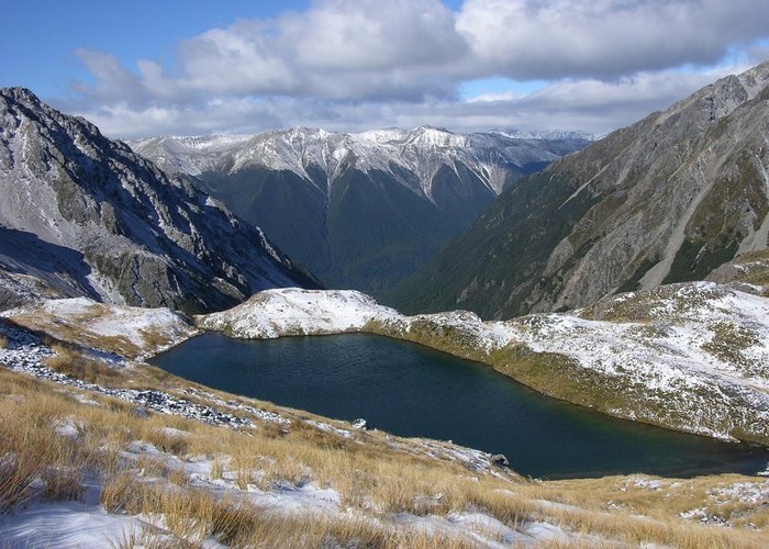
The route continues by sidling through scree to stony outcrops. There is a steep 10 metre plunge through the scree to reach the base of the outcrops and progress further along the slopes. The footing rapidly becomes better and you reach another saddle (west of point 1813) sooner than you would expect. By now lunchtime looms and the saddle is a convenient place for a break. You have a choice of views, either back (NW) into the alpine basin with its tempting blue tarns or forward over the fourth basin (more tarns!) to the junction of the Travers and Arnst Rivers.
The route heads to the west under a small bump and then arcs south along a long ridge. On your right, there is the valley containing Speargrass Creek - this is a good chance to have a look at the route out along this creek to Speargrass Hut. The only difficulty I could see was a steep section part of the way down the valley just before the waterfalls descending from a tarn on the other side of the valley. The ridge becomes rocky and narrow as it rises to point 1788. While the crest can be clambered along, the route takes the better and safer option of keeping a few metres down from the crest on the east side of the ridge. Even so, I made the walk a little more interesting by occasionally walking along the crest. A final rocky climb brings you to a pole stuck up on a small knob and a change in direction to the west.
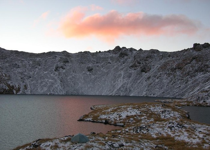
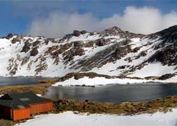
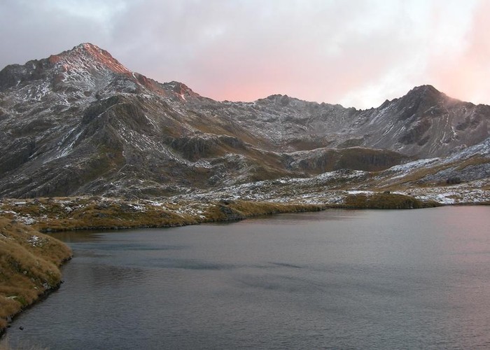
A few more rocks to clamber over and then the route takes yet another traverse below a peak on the ridge. At the end of the traverse there is a small drop to the saddle at the head of Speargrass Creek. There is a route down the creek to Speargrass Hut. There is one final climb up a scree slope to a last saddle overlooking Angelus lake, mountain and hut. Angelus Hut is obvious at the base of a peninsular that almost splits the lake in two. Its porch faces the saddle so the sharp-eyed among you can take a first guess at how full the hut will be. Note that the M29 Infomap (published in 1987) shows two buildings here but there is now only the main hut - the site of the other building on the peninsula is often used as a camping ground.
Beyond the lake there is a glimpse of the foot of Hinapouri Tarn with Sunset Saddle against the sky above it (directly to the south). There is a steep, slippery path through the scree to the lake shore 100 metres below or the brave can try running down the scree.
Out to Lakehead Hut and St. Arnaud
This track takes about 8 hours to get all the way to St. Arnaud but you can break the journey at either of the huts at head of Lake Rotoiti or book a water taxi from there.
The Cascade Track starts at the outfall from the lake. It begins as fairly steep and then gets even steeper. The first 100 metres are OK as you descend to follow the trickle of water from a tarn just below the lake. The next 100 metres though give a taste of the slopes to come as you drop down rocky slopes beside a waterfall. Below the waterfall, you leave the streamlet behind you and head off to the left towards the creeks emptying from Lake Angelus and Hinapouri Tarn. This soon leads to a abrupt fall through scree with plenty of excuses to stop and admire the many fine waterfalls around you.
This steep section ends as you cross Hukere Stream just below the junction of the two creeks. Note that this ford may be impassable after heavy rain. The track enters stunted mountain beech forest for a less steep descent to a large alpine clearing (a wonderful site for camping). The beautiful beech forest will accompany you all the way down to the Travers River. From the clearing, a well-padded track continues down the stream with a series of flat sections separated by steep descents. Of interest are:
- An area where the stream and track are squeezed between fans of scree and boulders falling from either side of the valley.
- The map shows the track to be on the true right of the stream all the way down. However there is one point where the track crosses the stream to avoid a large tangle of uprooted trees.
- A long plunge alongside an old stream course or flood channel while the stream vanishes off to your left and out of hearing. At the base of the descent, the stream reappears with a nice little waterfall.
- As the valley bends north to join the Travers Valley there is one last steep section beside a gushing cascade. Once past this, there is level going all the way to the Travers Valley (about 3 hours from the top clearing, 4 from the hut).
The junction with the track up the Travers Valley is a few metres upriver from the swingbridge across the Hukere Stream. Those of you heading for Coldwater Hut will head across the bridge and then downriver. Lakehead Hut can also be accessed by going directly downriver but only if you are sure of being able to ford the Travers River.
If the river is in flood then head upriver to the swingbridge across the river about 20 minutes away. This is thoroughly pleasant walking along gentle river flats. There is a long grassy area well suited for a bit of a break (various insects allowing) just before the bridge.
The bridge stretches across the river to a rocky bluff where a metal rope helps you keep to the track. Take care rubbing your hand along the rope since there are a few spiky metal strands poking out (as I quickly found out). The hut is less than an hours stroll downriver through the beech forest and then scattered scrub and clearings filled with old burnt-off trees. When the track climbs around a river bluff, the hut is quite near.
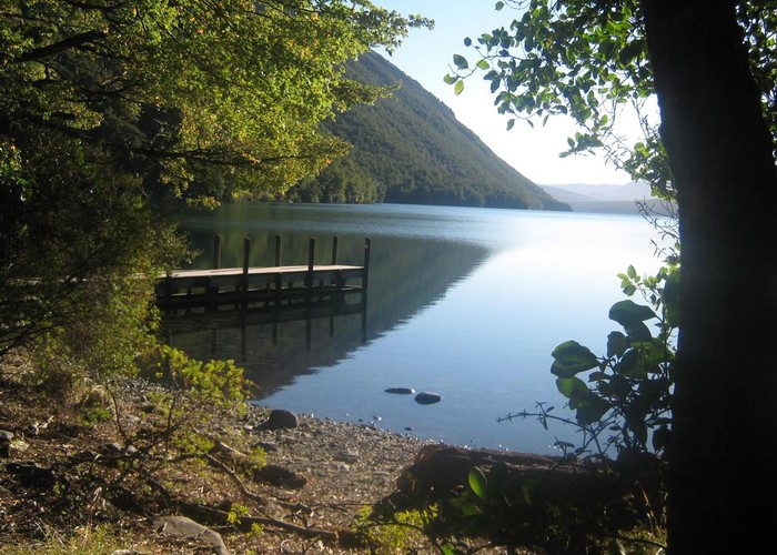
There is not much to say about the lake-side walk - it's enjoyable, the beech forest is delightful and there are lots of chances of views up and down the lake from the shore and the open areas at a couple of stream deltas. It only takes 3 hours so you can stretch it out by heading up the Loop Track as you near St. Arnaud which climbs 160m up through the bush to Borlase Stream and then drops down to the lake again. If you have even more time then hide your packs near the stream and climb up the St. Arnaud Track for wide views.