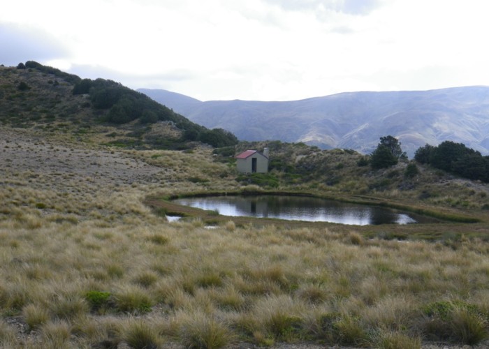
Tarn Hut, Lilburne Hill
4 bed hut built in 1960's by Bruce Hassal of the NZFS (Simon Hassal's father) on a sheltered spot lee to a small ridge on De Bourbles land. As part of the agreement, the NZFS constructed a 4WD track up to the ridge and along to the hut. The farmer eventually reneged on this and banned foot access to the hut via this track. His reason was alleged interference with his stock. Recently, the hill has been destocked and now the land has been taken over by Mt Pember Station. They have resumed the agreement and now allow the public to use this track again. In the meantime, DoC constructed an unpleasant but direct track up to Lilburne Hill via Tent Gully. This hut can also be accessed via the head of the Ashley river and Youngman (Puketeraki) Hut.
|
Owner
|
Owner: DOC |
|---|---|
|
Category
|
Standard Hut |
|
Sleeps
|
Sleeps 4
4
|
|
Facilities
|
Enclosed wood/coal burner |
|
Water supply
|
No water |
|
Getting there
|
Via the Ashley River/Lilburne River Junction Ridge Track (ex-4WD) or the Tent Gully track and finally via the track that leads directly to Lilburne Hill from the Youngman Hut. |
|---|---|
|
Unlocked
|
This hut is unlocked and open to access. |
|
Bookings
|
No bookings — open access
No — open access
|
|
Altitude
|
1,274m |
|---|---|
|
Mobile phone coverage
|
No coverage |
|
Maps
|
NZTopo50-BV22
|
ID 7259
About this hut
101 views in the past year (8 per month).