Rockslide Hut / Biv
Ruahine Forest Park
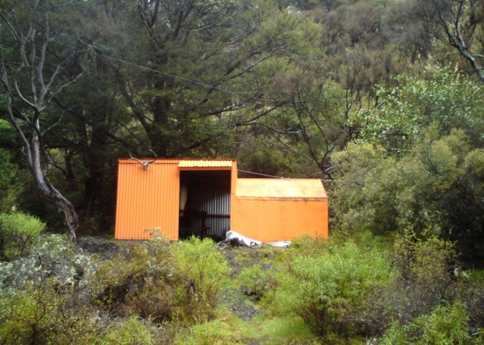
A dog-box bivvy on Apias creek, with a full height shelter tacked on the door gable-end wall. The bivvy sleeps two, and the shelter has 1 set of bunks for two more. Water is from the creek 50m away, and a fireplace out the back makes up the cooking facilities. The shelter has a doorway at front and back, but no doors, ensuring a good through draft. The shelter also lacks a floor, sitting on sharp river gravel (an improvement on the mud of the similar Sparrowhawk) The biv itself is, by comparison, snug and weathertight. This hut is still DoC owned, and well maintained, unlike the identical Mistake Biv 3km upriver.
The hut takes its name from the huge rockslide opposite. This is grassing over in places and deer are a common sight. Similar slips continue for 2km upriver and 1km downriver.
The ridge behind the hut provides access to the main range.
An orange-painted pile of rocks marks the track to the hut from the river.
|
Owner
|
Owner: DOC |
|---|---|
|
Category
|
Basic Hut/Bivvy |
|
Sleeps
|
Sleeps 4
4
|
|
Facilities
|
Toilet |
|
Water supply
|
Tap or tank water |
|
Getting there
|
Mo Mans roadend: 5.5km via 'Maori Highway' (bulldozed track over Maori land). Marked route starts 1km upriver Ikawetea Forks: 7km, 1.5-3 hours. Riverbed route / track. Look for triangle on left above 20m falls marking start of track Mistake Biv: 3km, 1-2hrs, riverbed route. Onward routes to Aranga Hut / No Mans via ridges north and south (4km, 1.5-3hrs) Sentry Box / Masters Shelter: route / track, 5-10 hours via Aranga Hut. |
|---|---|
|
Unlocked
|
This hut is unlocked and open to access. |
|
Bookings
|
No bookings — open access
No — open access
|
|
Altitude
|
750m |
|---|---|
|
Mobile phone coverage
|
No coverage |
|
Maps
|
NZTopo50-BK37
|