Tongariro Northern Circuit
Tongariro National Park, Tongariro National Park World Heritage Area
- 3 – 4 days loop track
- Easy/medium
- Bookings required
- Whakapapa Village to Mangatepopo Hut, 3 hours
- Mangatepopo Hut to Emerald Lakes, 3.5 - 5.5 hours
- Emerald Lakes to Oturere Hut: 2.5 - 3.5 hours
- Oturere Hut to Waihohonu Hut, 2 - 3 hours
- Waihohonu Hut to Whakapapa Village, 5 - 6 hours
- Mount Ngauruhoe summit: 3 hours return
- Mount Tongariro summit: 2 hours return
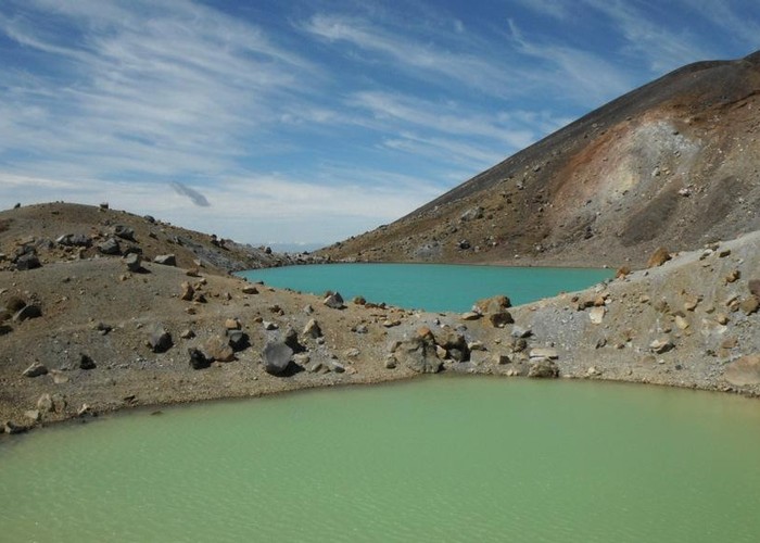
- Blue Lake viewpoint from Emerald Lakes: 30 minutes return
- Round The Mountain Track: 4 - 6 days
- Lower Tama Lake: 20 minutes return
- Upper Tama Lake: 1.5 hours return
- Access from Mangatepopo Road: 15 minutes
- Access from Lake Rotoaira Road: 2.5 - 3.5 hours
- Access from SH1: 2 hours
This circuit on the Volcanic Plateau passes close to the summit of Tongariro in a spectacular, active volcanic landscape of crater lakes, lava flows, and hot springs. A side-trip leads to the summit of Ngauruhoe.
|
Walking time
|
3 – 4 days
16 hr
|
|---|---|
|
Distance
|
43.1km |
|
Type
|
Loop track
|
|
Grade
|
Easy/medium
The track is alpine, and exposed to variable weather conditions. A volcanic hazard also exists. Grades explained
|
|
Bookings
|
Bookings required
Required
Great Walks booking season is 20 October - 30 April. Huts and campsites must be booked in advance.
|
|
Starts
|
Ngauruhoe Terrace, Whakapapa |
|---|---|
|
Maps
|
NZTopo50-BH34
NZTopo50-BJ34 NZTopo50-BJ35 NZTopo50-BH35 |
|
Altitude
|
1,090m
–
1,868m
Altitude change 778m
|
|
Link
|
www.doc.govt.nz/tongarironortherncircuithttp://www.doc.govt.nz/tongarironortherncircuit |
|---|---|
|
Bookings
|
The busy Tongariro Alpine Crossing draws the crowds, but the Tongariro Northern Circuit takes a more in depth look at the Volcanic Plateau. It includes the Crossing, but also visits the eastern and southern slopes of Mount Ngauruhoe, passing by the handsome Tama Lakes.
This track is managed as a Great Walk, meaning that bookings are required during the peak season, and that camping is prohibited within 500m of the track, except at the designated campsites at each of the huts. Winter conditions effectively close the track to most trampers, with snow and avalanche hazards.
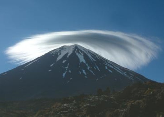
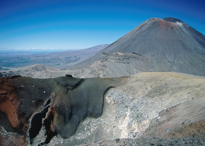
The Volcanic Plateau hosts three active volcanoes: Tongariro, Ruapehu, and young Ngauruhoe. These volcanoes erupt regularly. The most recent eruption was in 2012 at Te Maari, and damaged the nearby Ketetahi Hut. Warning signs indicate the current hazard level.
Access
This circuit has several entry points. It starts and finishes at Whakapapa Village. It is also accessible from the two ends of the Tongariro Alpine Crossing at Mangatepopo Road and Rotoaira Road, and from SH1, the Desert Road. Public transport is available to National Park on SH4 and to Whakapapa Village.
Whakapapa Village to Mangatepopo Hut
Meandering through tussock and beech forest, the track soon meets the tail of the Tongariro Alpine Crossing, with the car park to the left and the hut nearby, to the right.
Mangatepopo Hut to Emerald Lakes
Passing the Soda Springs, the track climbs onto the South Crater and past the dramatic Red Crater. A 2 hour side track leads to the summit of Tongariro (1961m). The track drops off the crater to the mineral-stained Emerald Lakes.
Emerald Lakes to Oturere Hut
From the Emerald Lakes, the Crossing carries onward, but the Northern Circuit branches off to the right, dropping swiftly down the raw volcanic slopes of the Oturere Valley to the next hut.
Oturere Hut to Waihohonu Hut
An undulating track passes over bare ground and along forested streams.
At Waihohonu Hut, an access track leads out to SH1, and the Round The Mountain Track heads south to encircle Ruapehu.
Waihohonu Hut to Whakapapa Village
Passing Old Waihohonu Hut (no accommodation), the track climbs onto Tama Saddle where a short side track leads to Tama Lakes. From here the track returns to Whakapapa, passing the Taranaki Falls on the way.
Walking times
Side trips: