Kepler Track
Fiordland National Park
- 3 – 4 days loop track
- Medium
- Bookings required
Popular loop track providing access to the mountains around Lake Te Anau.
|
Walking time
|
3 – 4 days
19 hr – 23 hr
|
|---|---|
|
Distance
|
60.0km |
|
Type
|
Loop track
|
|
Grade
|
Medium |
|
Bookings
|
Bookings required
Required
Huts and campsites must be booked during peak season (October to April).
|
|
Starts
|
Visitor Centre, Te Anau |
|---|---|
|
Maps
|
NZTopo50-CD07
NZTopo50-CD08 |
|
Link
|
www.doc.govt.nz/parks-and-recreation/tracks-and-walks/fiordland/eastern-fiordland/kepler-track/http://www.doc.govt.nz/parks-and-recreation/tracks-and-walks/fiordland/eastern-fiordland/kepler-track/ |
|---|
Situated at the foot of Lake Te Anau, it was constructed in 1988, and established as a Great Walk to ease the pressure on the other Great Walks in the vicinity. The modern track has been carefully designed with smooth grades and well-spaced huts and shelters. Camping is prohibited on the Kepler Track except at the two designated campsites, although free camping is available off the track at Shallow Bay.
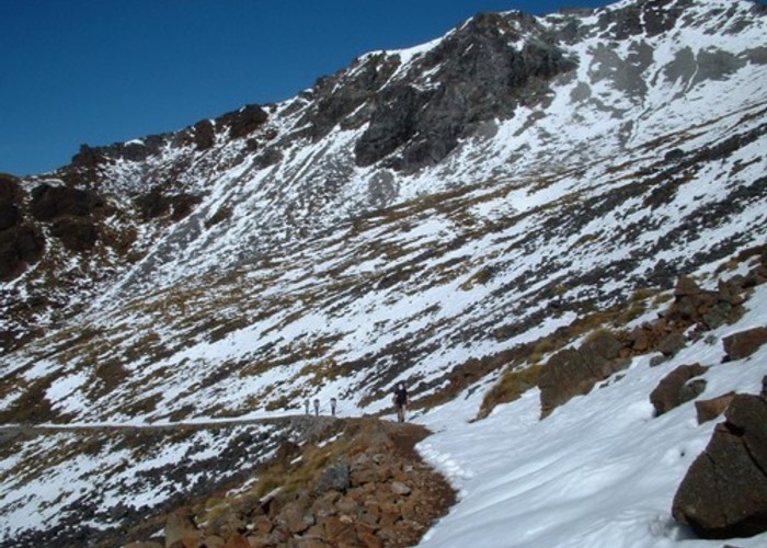
The alpine section of the track may be impassable due to snowfall during winter and spring.
Access
Shuttle buses run regularly to the track ends at the Control Gates and Rainbow Reach, and a number of boat services provide transport across the lake to Brod Bay. Alternatively, you can walk to the Control Gates along a lake-side track beginning at the Fiordland National Park Visitor Centre, Lake Front Drive, Te Anau. This walk takes ¾ hr.
Lake Te Anau Outlet Control Gate -- Brod Bay: 1½ hr
Bending northward around the lake-shore, the track comes quickly to Dock Bay. Dock Bay Picnic Area: Toilets. Brod Bay is a little further on.
Brod Bay -- Mt Luxmore Hut: 3½-4½ hr
The track turns inland and climbs past limestone bluffs and above the bush-line. The hut is reached soon after.
Mt Luxmore Hut -- Iris Burn Hut: 5-6 hr
Poor weather can hamper the commencement of the alpine crossing from here. The track climbs, nearing the summit of Mt Luxmore and descending to a shelter near Forest Burn Saddle.
It is two hours to the next shelter.
A series of zigzags lead down into Hanging Valley and towards Iris Burn Hut.
The Iris Burn Waterfall is situated on the track leading 20 minutes upstream from the hut.
Iris Burn Hut -- Moturau Hut: 5-6 hr
The Iris Burn runs out to Lake Manapouri and the track follows on the true left bank to the lake-shore, descending most of the way. Moturau Hut is situated on the lake-shore in Shallow Bay.
Moturau Hut -- Rainbow Reach: 1½ hr
An easy track continues around the bay with a side track soon leading down to the Shallow Bay Hut and camping area.
The boardwalked track crosses a kettle bog, passing a wetland viewing platform, before crossing the Forest Burn. This river opens out here onto the Balloon Loop, an old bend of the Waiau River. The Waiau River is followed until a swingbridge crosses to the Rainbow Reach Car Park.
Rainbow Reach -- Lake Te Anau Outlet Control Gates: 2½-3½ hr
The Waiau River runs the short distance between Lake Te Anau and Lake Manapouri. The Kepler Track follows it on the true right for much of this length, coming out at the Control Gates.