Te Aroha - Waitawheta Tramway Circuit
Kaimai-Mamaku Forest Park
- 2 – 3 days loop track
- Medium
A varied loop through Kaimai Mamaku Forest Park, including both the highest point in the park and a section of the famous Waitawheta Tramway, and exploring the park's mining and milling history.
|
Walking time
|
2 – 3 days
15 hr
|
|---|---|
|
Distance
|
24.0km |
|
Type
|
Loop track
|
|
Grade
|
Medium |
|
Bookings
|
No bookings — open access
No — open access
|
|
Starts
|
Next to the Te Aroha Mineral Spas ticket office, Boundary Street, Te Aroha |
|---|---|
|
Ends
|
Reservoir above Lawrence Avenue, Te Aroha |
|
Maps
|
NZTopo50-BC35
|
|
Altitude
|
40m
–
953m
Altitude change 913m
|
Te Aroha - Waitawheta Hut, 7-7.5 hours
Setting off from the town of Te Aroha in the west, this loop crosses into the ranges by climbing to the highest point in the park, the modest peak of Te Aroha at just 935m. From here, the Northeast Track leads down to the Waitawheta Tramway. The wide, groomed tramway is quite a contrast from the rough and muddy Northeast Track. The return to Te Aroha is via Daly's Clearing, and along the historic yet tedious Mangakino Pack Track. The route passes through a disshevelled mining area shortly before the township.
Consider allowing a leisurely day around Waitawheta Hut to explore the milling relics and the short tracks nearby. A day walk into Ananui Falls is an option from here too.
From Te Aroha township, a track climbs to the summit in just 2 hours. Refer to Mount Te Aroha for details. Under the shadow of the massive transmitter tower, the trig marker looks tiny, but there is a plane table nearby, with good views of the route ahead.
A network of short mining pack tracks cover the area around Te Aroha, and this route follows a few of them. Take the Ridge Track (marked as leading to "Dog Kennel Flat") which starts just a few metres beyond the end of the Mountain Track. Winding easily down to a junction at Dog Kennel Flat, the Ridge Track passes a junction. Take the track to the right: this is the Plutus Claim Track, an old mining pack track.
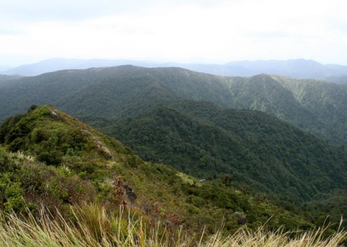
2 hours from the summit, the Mangakino Pack Track crosses, leading from Waihi in the north to the goldfields of the Waiorongomai Valley in the south. Continue along the signposted Crimson Thread Track. An easy sidle along a forest ridge leads to the junction with the North-South Track after 40 minutes. The forest is scrubby here and seems to be thinking about subalpine scrub without quite becoming so.
The section of the North-South Route to the right is no longer maintained and overgrown. So turn left instead, and take the track down into the Waitawheta Valley. This track which leads through light scrub, seems to be only maintained to a very rudimentary standard. It is largely a muddy channel filled with water, and overhung with grasses. Slow, wet progress, although a breaststroke technique is effective at clearing a way through the grasses. Soon the vague track leads into a pretty forest of tawa and pukatea, and down to a couple of bridges.
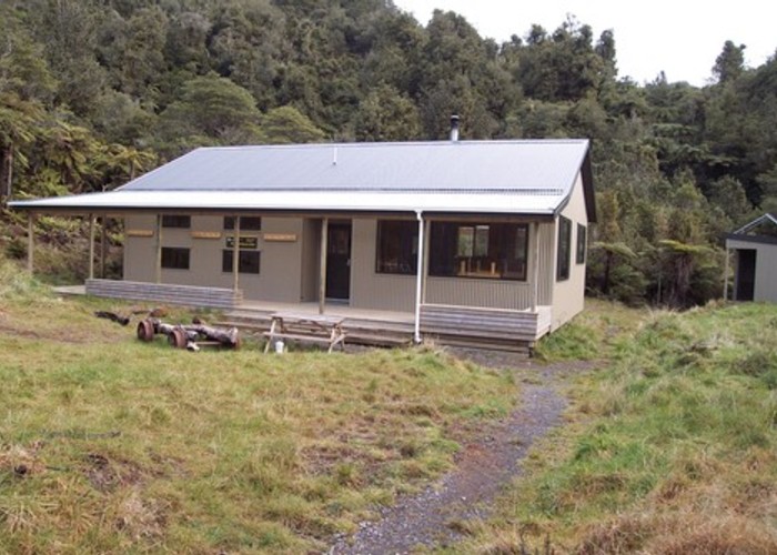
A large grassy clearing marks the site of the old hut on the Waitawheta Tramway. There is ample camping here by the river, and a new toilet. 2 hours from the North-South Route junction.
The Tramway is a smooth and easy stroll from here in both directions. So stroll southwards 30 minutes to the new hut, past a little gorge and over a bridge by an impressive eddy carved into the rock. The Waitawheta Hut is located in the midst of a large grassy clearing, and surrounded by kauri stumps, and logging relics. A few short tracks in the area explore the history.
Waitawheta Hut - Daly's Clearing Hut, 2.5 hours
From Waitawheta Hut, retrace your steps down the valley to the Waitawheta Campsite. Beyond here, the tramway once crossed the river on a wooden trestle. All that remains are the concrete foundations. Ford the river, and continue along the straight, smooth tramway. Sleepers are often visible, although there is not much iron: it was usually removed and reused at other sites.
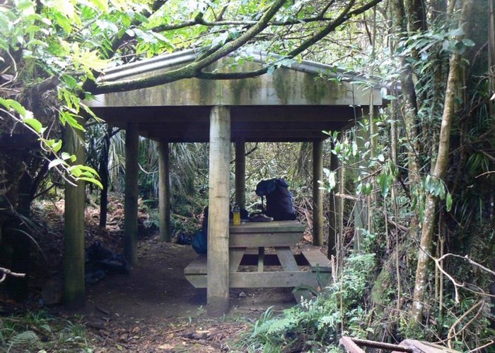
The river starts to bend wildly, with impressive cliffs looming either side. After three more crossings, the last is bridged. The new DOC bridge is wide and sturdy. To the right, the Bluff Stream Track turns off, and to the left the track to Daly's Hut sets off a few minutes later (2 hours from the hut). A gentle climb through regenerating scrub leads quickly to the grassy clearing and Daly's Hut.
Daly's Clearing Hut - Te Aroha, 6.5 hours
Passing through a pretty patch of nikau just outside the hut, the track heads westward to the Mangakino River, and the Pack Track in just a few minutes. The Mangakino Pack Track heads both north and south from here. Turn left and take the track south. It is a wide, and well benched track cut in the 1880s, Pretty soon though, it deteriorates, and becomes a scramble. The easy sidle marked on the map is deceptive, as the track itself is poorly maintained and rather monotonous, although there are some large kauri and pretty forest along the way.
2 hours 45 minutes from the hut, the track crosses the river and passes the Mangakino Shelter and Campsite. It climbs to a junction, where a track leads southward into the Waiorongomai Goldfields. Keep straight ahead on the track to Tui Saddle, and then right, down the wide old Tui Road to the mine (1 hour 20 minutes from the Mangakino Shelter).
The Tui Mine site is desolate and messy. The adit itself is tucked discreetly into the hillside, but tailings dominate the valley, and have completely destroyed the shape of the stream. From here it is still another 2 hours to Te Aroha -- follow the track down the valley. Refer to the end of Mount Te Aroha for details.