Caples Track
- 2 days one way
- Easy/medium
- Greenstone road end to Greenstone / Caples confluence: 30 minutes
- Greenstone / Caples confluence to Mid Caples Hut: 2-2.5 hours
- Mid Caples Hut to McKellar Saddle 4.5-5.5 hours
- McKellar Saddle to Lake McKellar Junction: 1-2 hours
- Lake McKellar junction to Howden Hut: 1 hour
- Howden Hut to The Divide: 1 hour
A quiet track climbing alongside the Caples River through forest and grassy flats and over a sub-alpine saddle.
|
Walking time
|
2 days
9 hr – 11 hr
|
|---|---|
|
Distance
|
33.0km |
|
Type
|
One way
|
|
Grade
|
Easy/medium |
|
Bookings
|
No bookings — open access
No — open access
|
|
Starts
|
Greenstone River mouth, Lake Wakatipu |
|---|---|
|
Ends
|
The Divide, Milford Te Anau Road |
|
Maps
|
NZTopo50-CB09
NZTopo50-CB10 |
|
Altitude
|
340m
–
945m
Altitude change 605m
|
|
Link
|
www.doc.govt.nz/parks-and-recreation/tracks-and-walks/otago/queenstown-wakatipu/greenstone-and-caples-tracks/http://www.doc.govt.nz/parks-and-recreation/tracks-and-walks/otago/queenstown-wakatipu/greenstone-and-caples-tracks/ |
|---|
Options
The Caples Track crosses an alpine saddle between Otago and Fiordland, connecting up with the well known Greenstone and Routeburn Tracks, as well as the less popular Mavora Walkway. Extend your experience and ease transport problems by linking tracks together. The Greenstone / Caples loop is a 4 day complete circuit starting from the Milford Road or from Lake Wakatipu. The Routeburn / Caples combination is 4-5 days, from Lake Wakatipu. If you have your own car, you will need to arrange track transport from end to end. You could even link all three together for a 6-7 day grand tour. While the alpine scenery of the Routeburn is more dramatic, walkers appreciate the low-key serenity of the Greenstone and Caples neighbours. Just remember that hut bookings are essential on the Routeburn Track.
Huts, camping, and private land
The grassy flats of the Caples valley are private farmland. Keep to the track. Camping is allowed along the bush edge. If camping next to the huts, there are fees of $5 per night for adults and $2.50 per night for children. An informal camping area with toilet is also established at Greenstone Saddle. Camping is prohibited between Upper Caples Hut and Lake McKellar due to the fragile ecosystem.
There are several huts along the way. Mid Caples Hut is the first, paid for with DOC hut tickets. Next is Upper Caples Hut with is managed by the Southern Lakes Deerstalkers Association. This is available for use but must be booked. McKellar Hut is another near the western end, a short detour down the Greenstone Valley, and also paid for with hut tickets. Finally, there is Howden Hut, which is managed as part of the Routeburn Track and requires bookings. Toilets, parking, and information shelters are available at both track ends.
Access
The western end is located inside Fiordland National Park on SH94 at The Divide. This is better known as the end of the Routeburn Track. The eastern end is at the end of the Greenstone Road, a rough 4WD road leading south from Kinloch, next to Lake Wakatipu. Track transport is readily available to both ends. Note that the ends are a long way apart by road.
Greenstone car park to Mid Caples Hut
From the car park, the track follows the true left of the Greenstone River, passing a bridge to the Lake Rere Track. Looking down on the confluence of the Greenstone and Caples Rivers, the track continues straight ahead and passes a bridge leading up the Greenstone Valley. The Caples Track follows river flats, keeping for the most part to the bush. Cattle graze in these grass flats, which are leased to local farms. Pairs of Paradise shelducks are persistent, noisy company. They have a habit of synchronising their individual monosyllabic calls, creating a bizarre stereophonic effect. Across the river, the poplars around the Birchdale Homestead are markers that draw slowly nearer. (New Zealand "beeches" were once known as "birches.") A shack and old fences can be seen, but the homestead itself seems to be only visible once you have walked well past it. Nearing the Mid Caples Hut, the track crosses an open space before entering forest and climbing briefly onto an old terrace. Here the river is compressed into a very deep and narrow gorge spanned by a small bridge. The hut perches on the opposite bank.
Mid Caples Hut to McKellar Saddle
Wandering along a grassy terrace on the true right bank, the track drops occasionally onto the stony river-bank. Stones in the creeks are a colourful mixture of red and green sandstones containing, in several different combinations, lumps of red or green mudstone. These colours reflect the presence of iron in the minerals chlorite (green) and hematite (red). Similar stones are also found in the Greenstone Valley.
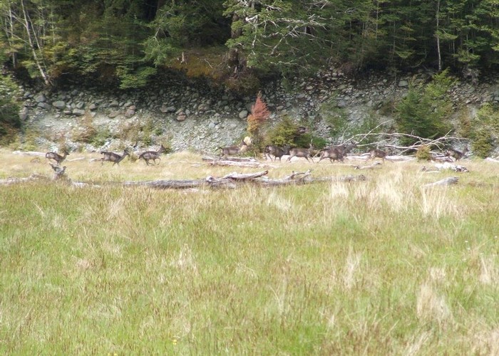
Forest closes in occasionally, pinching off a series of river flats. Black fallow deer are common on the flats. As the flats become smaller and the valley narrower the track stays in bush, soon reaching the Upper Caples Hut in the small clearing of Tent Flat. This hut is locked and owned by the deerstalkers association. It is available for public use via bookings. Riflemen, robins and brown creepers inhabit the forest around the hut. Corybas orchids may be found in the boggier ground. Deer sometimes lurk outside the hut in the evening and early morning.
Entering mossy beech forest the track begins the climb toward McKellar Saddle. Watch for the brightly coloured yellowheads on the track and listen for the chatter of yellow-crowned parakeets in the canopy. The distribution of yellowheads is now severely limited and they are a memorable, although fleeting, sight. Parakeets are commonly heard, but they are not seen so easily, and they are shy of people. Often these two species are found in close proximity. In warmer months listen also for the calls of the shining cuckoo and the long-tailed cuckoo. The first sings a series of watery rising notes followed by one or two falling notes, reminiscent of some introduced species. The second produces a loud, insect-like, rising screech.
The track flattens off and resumes climbing several times before clambering with difficulty along the bouldery river-bank and crossing what remains of the Caples River. From here it climbs vigorously into the subalpine zone and onto McKellar Saddle. The ground is boggy with small tarns and a length of boardwalk to protect the plant communities. At the point where the track begins the descent into the Greenstone Valley you can observe a ridge of the Livingstone Mountains opposite, beyond which lies the Milford Road. Lake McKellar skulks below you on the valley floor. The Darran Mountains are visible to the right.
McKellar Saddle to Lake McKellar Junction
The 300m drop into the Greenstone Valley was once steep, rocky and slow. However, it has recently been realigned to make the descent easier. The track then moves up-valley past the head of the lake, on a poorly defined trail, finally turning onto the boggy flats and crossing to the western side of the valley where the Greenstone Track leads north and south. A sign indicates Howden Hut to the north and McKellar Hut to the south. From here you can exit onto the Milford Road at the Divide or you can turn down the Greenstone Valley to loop back to the beginning of the Caples Track.
Lake McKellar Junction to The Divide
Heading up the Greenstone Valley, the track leads over the gentle saddle with its camping area, past Lake Howden and down to Howden Hut on the busy Routeburn Track. From here, it's just another hour's walk out along the Routeburn highway, although an extra hour's detour up to Key Summit is well worth doing on a good day.