Big River
Victoria Forest Park
- 2 – 3 days loop with brief road section
- Medium
- Continue down the road to the boilers in the valley beneath the mine. At one point the track crosses a scree slope, which is tailings from the mine on the ridge above.
- A challenging shortcut is to take the side track to the poppet head. From here you will find a thin steel cable which is useful on the five minute descent of the scree to the buildings below.
Faded gold miners' trails into the remains of the Big River gold town, past old stamper batteries, rails, mines and buildings.
|
Walking time
|
2 – 3 days |
|---|---|
|
Distance
|
28.0km |
|
Type
|
Loop with brief road section
|
|
Grade
|
Medium |
|
Bookings
|
No bookings — open access
No — open access
|
|
Starts
|
Inangahua Swingbridge south of Reefton |
|---|---|
|
Maps
|
NZTopo50-BT21
|
|
Altitude
|
240m
–
820m
Altitude change 580m
|
A new DOC hut sits on a hillside overlooking the community where a few buildings still stand. Other historic sites can be visited as short walks from here. There is much to see so it is worthwhile to allow an extra day. The town is accessible via the Big River Road from Reefton, making it popular on weekends with mountain bikers, motorcyclists, four wheel drive vehicles and even horse parties. Trampers can walk in from Waiuta in the southwest, or from State Highway 7 via Deep Creek. The prescribed DOC route is from Waiuta to Big River, and then out along Deep Creek. A more practical option would be to walk in from Waiuta and then to return the same way; this is probably the easiest option. The route described here is more challenging: walk in via Deep Creek, trudging 1-1½ hours up a spur; from Big River follow the road out to Merrijiggs and then turn onto an old miners' road over to Rainy Creek. The road down Rainy Creek is overgrown, which is unfortunate because it is otherwise easy walking. You come out 2km north of your starting point.
Warning: the Big River Road-Rainy Creek section is affected by recent mining developments. Track details may have changed or been obliterated.
Access
Eleven kilometres south of Reefton on State Highway 7 a bridge crosses Rough or Tobin Stream (labelled, nevertheless, as "Branch Stream" on the bridge itself). Immediately north of this bridge a small road is signposted, giving access to the Inangahua Swingbridge. Follow it to a pretty picnic area.
Inangahua Swingbridge -- Inangahua River Ford: ¾-1 hr
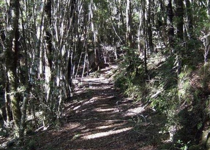
Cross the bridge and follow a well-maintained track up stairs and alongside an old, dry water race. Tunnels can be seen passing through small spurs and old timbers are visible where once small gullies were bridged. A series of long staircases drop into and back out of side-creeks, but the walking is easy (although the traffic noise is disconcerting). Finally you drop down to the Inangahua River where a sign indicates a ford back to the highway (don't ford the river). Good swimming here.
Ford -- Golden Lead Battery: 2-2½ hr
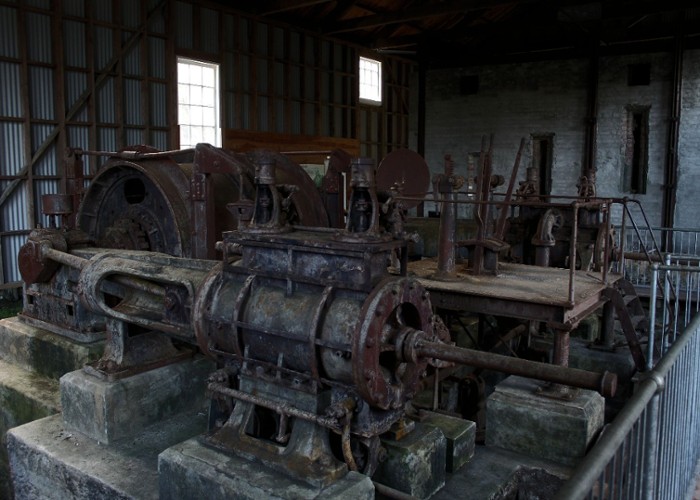
The track from here is rougher and all the old bridges have been knocked down, resulting in awkward scrambles. Along Deep Creek it is easier and quicker to drop down to the riverbed than to follow the track, which struggles along the valley well above the river and has slipped magnificently at one point. Eventually the valley flattens out and the track crosses the Cumberland Battery site, where there is little to see. A swingbridge crosses Deep Creek near here. If you have been following the riverbed, regain the track at this point. Fifteen minutes further on, a new wooden bridge crosses Golden Lead Creek over to the Golden Lead Battery, an excellent lunch stop (there's even a picnic table!). This battery is one of the best preserved in the region. The Golden Lead Mine is on the Big River Road on the hillside opposite and was once connected to this site by a cableway. Quartz was crushed here to extract the gold. A two minute track into the bush leads to a collapsed miner's hut. There is also a track up to the Big River Road.
Battery -- Head of Golden Lead Creek: 1½-2 hr
Collect some water and cross back over Golden Lead Creek. Follow the track to the right up a spur. The track climbs 440m in an unpleasant, continuous ascent. The forest changes as you climb, becoming lower and brighter, with rata, celery pine and cedar present; parakeets can be heard overhead. At the top, the track sidles and then drops steeply back into Golden Lead Creek.
Creek -- Big River: 1½ hr
An old tramway starts here with narrow rails accompanying you along a muddy track for the next half hour. After the end of the rails, the track continues on an old wide road. This climbs gradually, past a side track to the site of an old sawmill, eventually crossing a ridge where a track leads to the poppet head sitting atop the Big River Mine. Here you have two choices:
The remains of a cableway leading down to the battery at Big River can be seen in a nearby gully. It's twenty minutes to Big River, past an adit into the hillside on the right, the school site and a track to the left leading to "Tin Town," the single miners' huts. Ford Big River to the township site, which is largely bog. The hut is at the top of a short track on the low hillside opposite.
Big River
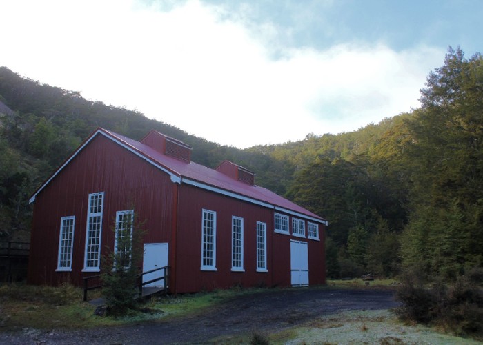
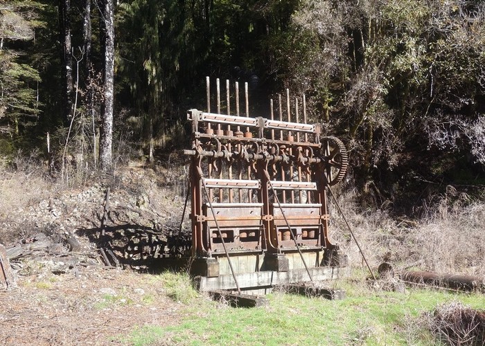
All that remain standing here are the battery, a series of cyanide tanks and two cottages. The cyanide process was employed in New Zealand from the turn of the century as a means to separate the gold from the quartz. It was twice as efficient as the previous method, which used mercury. The larger of the huts is Rooney's Cottage, and you can read all about Vera Rooney in the hut book. Frogs may be heard in the boggy flats and pipits are the dominant bird presence. Beside the track up to the hut grow tiny red sundews. About the size of a 50c piece, they supplement their mineral diet from the poor soil with live insects. Also visible are magnificent Thelymitra cyanea, beautiful blue sun orchids. The hut is quite new, with a sunny balcony. It has bunks for 35 but there is little living space and it gets cramped with far fewer occupants.
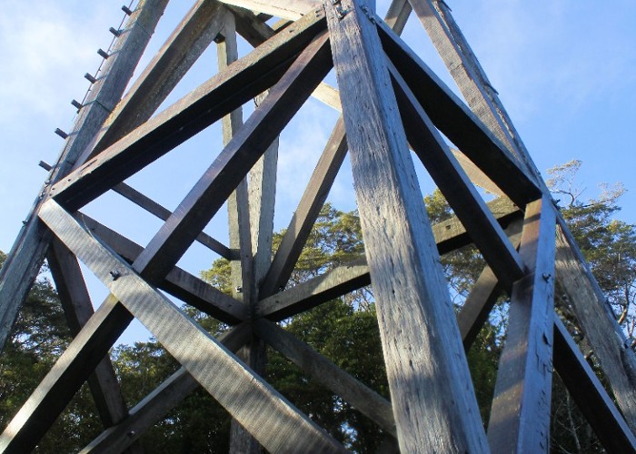
From the hut, the poppet head and the scree around the Big River Mine are clearly visible on a distant ridge. If you stay an extra day at the hut, it may be worth walking back to the boilers. From here you can climb up the scree to the mine shaft. This is covered by a heavy grille, so you can have fun listening to the air rushing past pieces of tailings as you drop them back in. It is a long way down (535m). 100 000 ounces of gold came out of this little hole. The poppet head is a large red beech structure, reconstructed recently by the Forest Service. It once supported the cables that lifted ore out of the mine.
An hour's walk from the hut leads to the old dam, from which a wooden race once carried water to the Big River Battery. The track branches off the route to Waiuta after a few minutes. It is lightly used and trees have fallen at several points. You soon break out onto boggy tussock river flats with a poled route marked across them. The dam is located at a narrow point between rock outcrops at the junction of two streams. The environment is wide, flat and rather surreal. Large, shiny flakes of muscovite mica along with tiny red garnets can be found in the pieces of granite here. The open plain upstream is a peat bog. Peat occurs in areas of poor drainage, where aerobic decomposition is not possible in the waterlogged soil. Organic matter builds up, becoming compressed as peat, and later, coal. The brown stain of the water also results from the peatland. Tannins are dissolved in the water, which is also the reason a cup of tea is brown.
Big River -- Sir Francis Drake Mine Site: 2½-3 hr
The route out from Big River Hut follows the four wheel drive road upriver, ascending gently and following a ridge beside Carr Creek. The travel is fast and easy although dull, with rare views and no water. Large sections of low, regenerating manuka forest are passed through, and bellbirds may accompany you some of the way. After 1½ hours a short adit is passed. The ceilings of some of these adits are covered with (harmless) cave wetas, which come out at night to feed on the forest floor. Glow worms can also be found. After a further 20 minutes an old road leads off to the left and the northern side of this thoroughly probed hill while the Big River Road climbs to traverse the southern side. Twenty minutes later the A1 Adit is passed, quickly succeeded by the OK Adit. This passage leads to a number of old, wet tunnels that head far into the hillside. A track soon leads to the right descending one hour to the Golden Lead Battery, and another soon after leads up to the Golden Lead Mine on the left. Further mines are passed to the left and a road bends down also from the left. Mounds of tailings from the Drake Mine are obvious on the right. There is a small creek here.
Mine Site -- SH 7: 2-2½ hr
It's ten minutes to the Merrijiggs Hotel site, a grassy space on the left, with the Scotia Mine site immediately after. An unused road branches off here to the right. Leave the Big River Road at this point. The old road continues as far as the Inangahua River and ensures a gentle gradient, if nothing else. Soon the track crosses the intersection of two new, wide mining roads on the diagonal. These roads are associated with the Macraes opencast mining operation, which threatens this landscape. The roads, needless to say, have been put through with no regard for the old roads or the trampers who use them. The track is rough on the other side and soon meets one of the roads again where a track branches leftward to Cornishtown. Our track crosses the new road and heads for Rainy Creek. When you turn onto Rainy Creek proper, the track disappears. The old road is overgrown with horopito, hook grass and tree ferns. But where you can find it, it is easier travel than the river bed. It can be found on the true right bank but becomes impenetrable quickly. Follow the creek down to a small two metre fall and try again on the true right. Occasional markers on trees provide little encouragement. A while later the road crosses to the true left and climbs a few metres above the river. A wide ledge is visible from the creekbed a few metres up on the left bank, and you can walk back to find the ford. The road continues on a high sidle, well above the river, for some time before dropping down again. An old moss-covered bridge is very nearly invisible, but quite rotten. The track becomes vague and eventually reappears on the true right, where it remains as a stripe of regrowth out to the Inangahua River. Ford the river, which is full of coal here, to the highway. It's only a couple of kilometres south to the Inangahua Swingbridge.