We left home bright and early on Saturday 22 November, and were at the start point by 7.15am. The beginning of this tramp is at the parking area at the end of Franklin Road, which is reached via SH2 (in the Karangahake gorge, near Waikino) - turn off into Waitawheta road, then right, into Franklin road - continue until reaching the parking area near the end, on the right.
The start of the tramp proper is another 20 metres down the road, on the right, up a set of steps set into the bank. The track follows a poled route through farmland and over a few fences for about 25 minutes until reaching the forest. This is quite a pleasant stroll, accompanied by a cacophony of bleating lambs from the neighbouring paddock. Once in the forest, another 30 mintues of pleasant, steady uphill walking brings one to the junction with the main North/South track, or Mangakino track as it is also known. A pleasant spot for a quick breather and a sip of water. Turn left, and follow the track south,climbing steadily, but not steeply.
This is section is quite pleasant - not at all difficult, and should be fine for even moderately fit people. About an hour later you should arrive at another junction - turn left here, to Daly's Clearing hut, which you should reach about 10 minutes later. Just a note reagrding the walking times - it should not be difficult to do the track sections within the times stated on the map, or in published literature - in fact we consistently did it in less time.
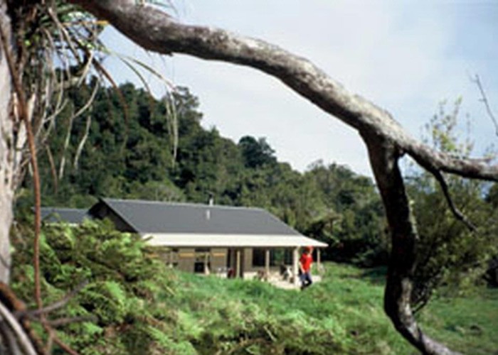
Daly's Clearing hut has been recently re-painted and repaired, and is a really nice, sunny spot for morning tea. The hut was clean and tidy, although the mattresses were quite holey (new mattresses installed since)!
From the hut, carry on down the track, and about 25 minutes later the Waitapheta river is reached - turn right, and follow the track along the river bank. This used to be the bed of a tramline, used for bringing out logs from the forestry operations further upstream - it has an interesting history behind it, worth reading up about.
Carry on along this track, and about 15 minutes later you'll reach a lovely waterfall on the right, with a nice spot for boiling the billy for a cuppa (which is exactly what we did!). From the waterfall it is about 10 minutes or so to the first river crossing. Be warned - there are six crossings in all before reaching the hut, and although the track itself is a doddle, the crossings take some thought and planning to execute safely, and without getting more than your feet wet! Don't try to cross by boulder hopping - it won't work - we tried. It took us half an hour to figure out how to best do the first one, but in the end we gave up, and plunged in. In my view this is the most difficult crossing, and the other five are easier, relatively speaking. Be careful, and ensure that your footing is secure before taking the next step, as the rocks and boulders are very slippery.
The rest of the track to the hut, crossing included, went without a hitch, and we accomplished the remaining five crossings in less time than it took us to figure out the first one.
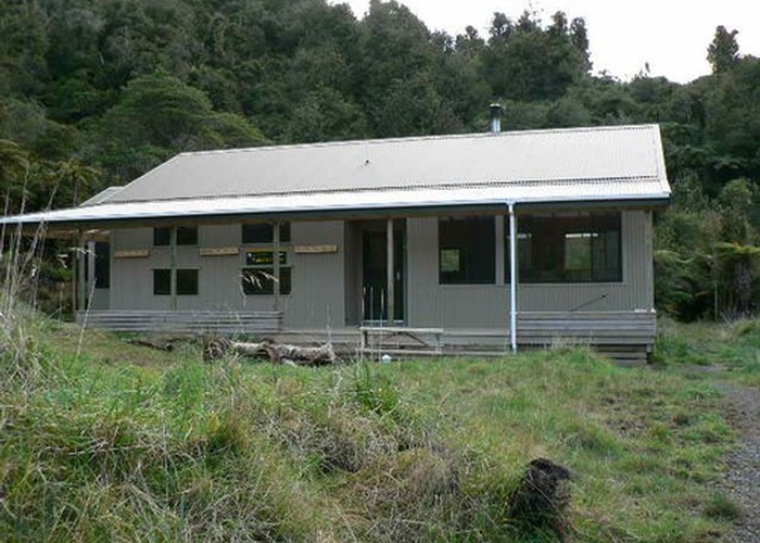
Our arrival at the (old) hut was a mixture of relief and dissappointment - relief at finally getting there, and dissappointment at the condition of the hut - quite abysmal, to be honest. Dark, smelly, damp and run-down would be kind, although the dunny is brand-new, and about as good as dunny's get! There is no water available at the hut, but as the river is just a hundred metres away, this is not a problem.We believe that DOC is planning a new hut at the Old Mill Site, another 20 minutes upstream (since built, and opened in Nov 2004 - light, airy and warm!)), and that the (old) Waitapheta hut is due for eventual demolition/removal (now removed).
We were surprised by the abundant birdlife around the hut - quite prolific, in comparison with some other tramps, where there was hardly any. We saw and heard fantails, swallows, magpies, yellowhammers, wood pigeons,etc.
Shortly after our arrival it started raining, and this continued off and on until the next morning. We were quite concerned, as the river level rises quite fast (according to the available literature), but to our relief it had risen only by a few inches on our departure. Needless to say the crossings on the way back were accomplished with even more finesse than the previous day, and we actually had good fun doing them - my wife even got her bottom wet on the last one, after slightly misjudging the depth of one gap between rocks. Another warning here - if you are caught at the hut by a flooded river, the alternative tramp is a six to seven hour slog over the top to Te Aroha, and an expensive taxi ride back to your car. It will pay to carefully check the weather report before setting off.
In summer this should be a delightful excursion - there are many, many great swimming holes, some quite deep. The water is crystal clear and one can quite easily see the bottom of all but the deepest holes. Whatever you do, take togs, and a diving mask if weight allows.
The walk back to Franklin road should take about three hours via the direct route(not returning via Daly's Clearing) stops excluded. It is, again, very pleasant and easy. Along certain sections it feels as if one is walking through a tunnel of bush, and when the sun shines into a clearing at the northern end, it actually looks like a train tunnel with a light at the end - makes for good photos!
The last half hour of the track is again through farmland - watch out for the cowpats and sheep-droppings - they make 'em large in this part of the world, and after crossing the river so many times, you wouldn't want to dirty those lovely clean boots now, would you?
We had a thouroughly enjoyable tramp, and would heartily recommend it to anyone looking for a leasurely weekend outing. Times - work on four and a half to five hours to the Waitapheta hut (via Daly's Clearing hut), and about three hours return. If you want to practise your river crossing skills, this is the walk to do it on.
Further reading: North Island Weekend Tramps, by Shaun Barnett, and the DOC pamphlet, "Kaimai Mamaku Forest Part Day Walks".