Section: Lake Guyon - Fowler Pass
St James Conservation Area
- 5 hr one way
- Easy/medium
- Lake Guyon junction to Lake Guyon: 30 minutes
- Lake Guyon to Stanley Vale: 1 hour
- Stanley Vale to Fowlers Pass: 2 hours 30 minutes
- Fowlers Pass to Fowlers Hut: 1 hour
- Edwards River - McArthur Track, 2 days from Lake Guyon junction to Tophouse Road at Edwards River
- Maling Pass - Moki Track, 1 day from Lake Tennyson to the Lake Guyon junction
A route connecting the Waiau Uwha and Waiau Toa (Clarence) valleys, from Lake Guyon junction on the St James Cycle Trail to Tophouse Road at Fowler Hut.
|
Walking time
|
1 day
5 hr
|
|---|---|
|
Distance
|
18.0km |
|
Type
|
One way
|
|
Grade
|
Easy/medium |
|
Bookings
|
No bookings — open access
No — open access
|
|
Starts
|
Lake Guyon junction, Waiau Uwha River |
|---|---|
|
Ends
|
Fowlers Hut, Tophouse Road |
|
Maps
|
NZTopo50-BT24
|
|
Altitude
|
806m
–
1,289m
Altitude change 483m
|
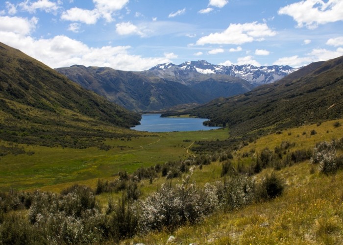
This route connects the mid-section of the St James Cycle Trail back to Tophouse Road, opening up two smaller loops, as well as the possibility of exploring around the Stanley River. The track is open to walkers and mountain bikes.
Access
To reach the western track end on the Waiau Uwha River, walk in via the southern or northern sections of the St James Cycle Trail.
To reach eastern track end, take the road out of Hanmer Springs over Jacks Pass. Turn off at the Clarence River and take Tophouse Road. The road is dirt and suitable for regular vehicles. However, it may be corrugated, and slow going. The St James Cycle Trail starts at the St James Homestead, which is nearby. Fowlers Hut is further along on the left, clearly visible. A toilet is located here, and it is a common spot for campers.
Lake Guyon junction to Lake Guyon
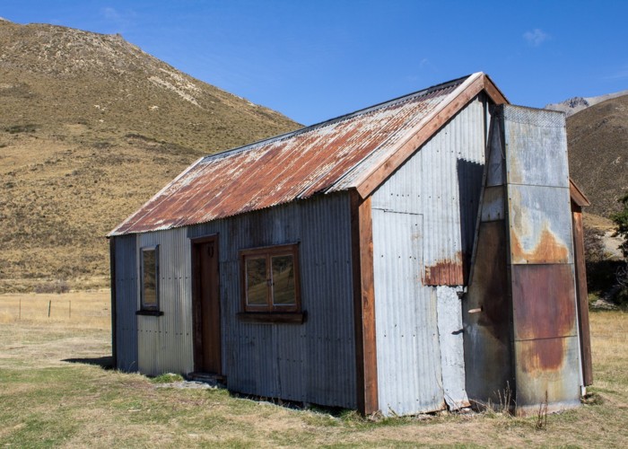
An old vehicle track climbs the gentle rise to the lake, crossing the stream and leading around the northern shoreline. Through a pocket of beech forest, the hut is located on the far side of a small peninsula at the edge of a clearing.
Lake Guyon Hut is very small, and well used by cyclists and fisher folk. There is however ample space to camp around the hut.
Lake Guyon Homestead was sited here in 1860, and remains of the cob house are still present, along with poplar trees, signs of a garden and walls. Hunt around for wild strawberries and gooseberries.
Lake Guyon to Stanley Vale
The route between Stanley Vale and Fowlers Hut is an historic pack track. A note in Stanley Vale Hut relates the tale of Bill Fowler lowering a wagon and five horses down the steep scree of Fowler Pass. The land around Stanley Vale was once farmed, and it is dotted with poplar and rowan trees, as well as a few gooseberry bushes. The homestead itself remains in good condition.
From Lake Guyon Hut, the vehicle track follows the lake edge through forest, soon curling around the end of the lake. At a marker, it turns off and heads up the valley. The track climbs through rowan trees up onto the rolling terrace of Stanley Vale. There are signs of past glaciation here, the curves of terminal moraines under the grasses.
A signposted junction indicates the track to Fowler Pass off to the left, and the route down Stanley River off to the right. Stanley Vale Hut is just along this track at the edge of the trees.
Stanley Vale to Fowlers Pass (1296m)
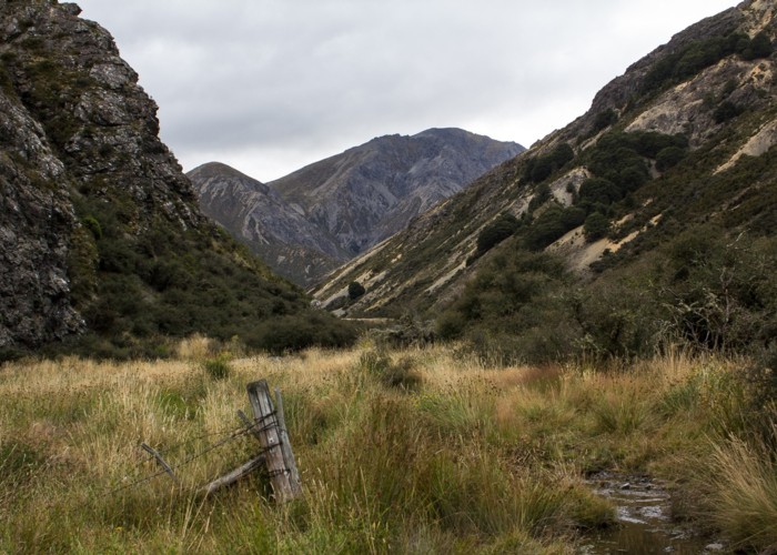
Back at the junction, a track heads off eastward and up the Stanley River Valley. The impressive slopes of Mount Clara (1945m) and the Birdcage are on the right, as the track drops off the terrace into the narrowing valley. The walking is easy, on a clear track through matagouri scrub, with the odd straightforward stream crossing.
The track passes Aniseed Valley and the scruffy Rabbit Hill as Long Spur comes into view. The track leaves Stanley River here and climbs over the nose of Long Spur, taking Smyths Stream. The stream soon branches again, and the track winds up a narrow gully to the right, still following Smyths Stream. The track climbs through herbfields with several stream crossings, then through a patch of beech forest marking Anniversary Point.
The high Smyths Stream catchment is largely a valley of scree, overlooked by the prominence of Mount Seymour (1793m). The track turns zigzags easily up to Fowler Pass and crosses into a different world. The southern side of the pass is a broad and tussocked valley of gentle slopes.
Fowlers Pass to Fowlers Hut
The route sidles easily down the valley, crossing the old pack track which takes an even gentler line, and soon drops the 350m to the road.