
Mt Pirongia, southwest of Hamilton, is the Waikato's highest point at 959m. Perched just below the summit is the relatively new 20 bunk Pahautea Hut alongside the old 6 bunk hut and there are several tracks up the mountain, all of which are rugged and muddy, making for a good adventure. I had previously been up four times to stay at Pahautea Hut but every time had been clagged in with no view, so when a couple of friends asked me to take them on a tramping trip I was eager to tackle Pirongia again. This would have to be one of my favourite weekend tramps close to Auckland.
There are two convenient loops up to the summit - we chose the longer and harder route from Limeworks Loop Road, up Tahuanui Track and down Bell Track. Many comments have been made throughout the years about the state Bell Track including statements such as "Short people may require a lifejacket" and "It may have been easier with snorkel and flippers"!
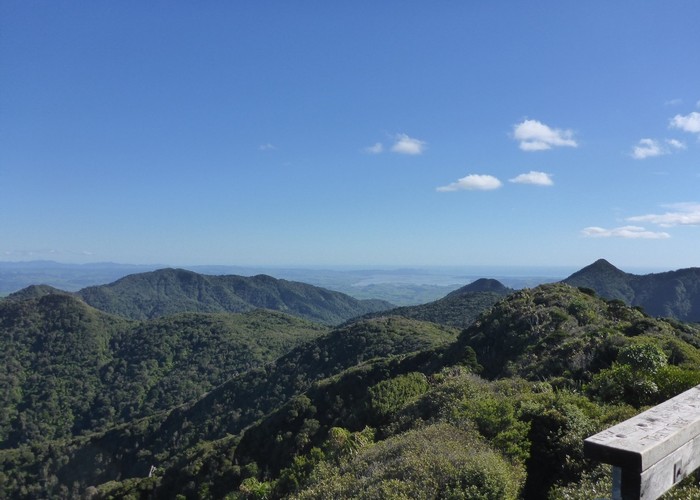
The first couple of kilometres is a gravel vehicle track alongside the Kaniwhaniwha Stream and was a nice gentle warm up. It took half an hour to reach the campsite, including a brief pause to find our first geocache of the weekend. Once onto the Tahuanui Track proper, the gentle but consistent climb began. The trail follows the almost straight ridge for several kilometres at a steady gradient before steepening up at the 700m mark. The track was pleasant going, although featureless, and I enjoyed being immersed in the bush. As altitude is gained the flora changes from tawa and podocarp canopy to stunted, twisted montane forest. The track also gets muddier the higher you get - which at first seems slightly paradoxical. However the mud should come as no surprise when you consider that the upper slopes of the mountain receive twice as much rainfall as the plains below. It is not until high up on the ridge that the first views are to be had; northwest to Mt Karioi and eastward over the Waikato. Reaching the boardwalk signals that the summit is nigh and the section from Tirohanga Track to the summit viewing platform is easy going. It was a bluebird day so the vista was grand - we could even see Mt Taranaki and Mt Ruapehu in the distance. I was glad to finally get a decent view on my fifth time up Pirongia!
Twenty minutes later we were peeling off muddy shoes and socks on the deck of Pahautea Hut, first to arrive for the day. After claiming some bunks we took a barefoot stroll along the 800m of boardwalk to Hihikiwi summit to find the geocache hidden there. The evening was whiled away relaxing on the deck, playing cards, reading, and solving crosswords with some of the other hut occupants. At sunset the horizon turned a brilliant orange, although the ridge blocked our view out to the west. We did go outside to look at the stars for a while, but although the sky was clear it was brightly illuminated by the almost full moon.
Pastel hues issued in the dawn, the air so still that cows could be heard mooing down on the farms below. With a long day ahead of us we made an early start and were soon packed up and heading off along Bell Track. The first 10 minutes is boardwalk, which then abruptly stopped and left us to the mercy of the mud as we picked our way carefully from root to root, balancing along logs and swinging around trees. The occasional exclamation punctuated our passage as one or other of us misjudged and planted a foot in the deep, sticky mud. 45 minutes of this saw us at the top of the Cone (953m) where Lydia retrieved another geocache from the scrub. A steep scramble down ensued, with no reprieve from the mud. Where the ridge flattens out around the 600m contour there was a change from mud to bog. Whereas so far there had been plenty of roots and trees to give a solid footstep, now it was just knee deep ooze. At first we all tried inching along the vegetation at the sides, but after one foot slipped in I yielded and just waded through (at least where it didn't look too deep). It was actually quite fun wallowing along!
Central Clearing Campsite provided a nice dry lunch spot (and another geocache) and we had a quick poke around to find the water source for future reference. Not far past, in a smaller clearing, there was an abundance of blackberry bushes so we stopped to forage for late-season berries. From here it was another couple of relatively mud-free kilometres along the plateau before dropping down to Blue Bill Stream. Dropping packs we took the 10 minute detour out to the tallest recorded native tree in New Zealand, which is a 66.5 metre tall Kahikatea. For some reason I had mis-remembered the next two kilometres along the stream as being good track and easy going so it took longer than I expected to reach the Kaniwhaniwha caves. These are the only two known limestone caves on Mt Pirongia, the main one being 20m long and just wide enough to walk through. We quickly scrambled through before trundling on. By now our legs were weary and the gravel plod back to the car, although easy, was hard on the feet.