Mt Fox Route
- 4 hr – 8 hr return by the same track
- Medium
A marked route from State Highway 6 a little south of Fox Glacier up to the open tops via Mt Fox. At first it is a cut and marked track and then it becomes a snow poled route as far as Point 1345m.
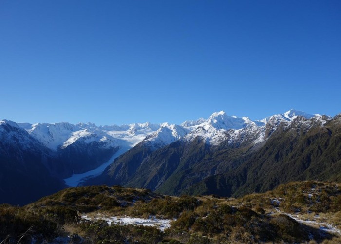
Once c.1200m and higher altitudes are reached there are fantastic views of one of the highest sections of the southern alps. You see can see the Fox Glacier, Mt Tasman etc to the east. There are unimpeded views west to the Tasman Sea.
3 members favourited
1 member checked in
|
Walking time
|
1 day
4 hr – 8 hr
|
|---|---|
|
Distance
|
7.4km |
|
Type
|
Return by the same track
|
|
Grade
|
Medium
Steep and a bit of a scrambley climb up tree roots in places through the bush section. Some muddy patches in the sub alpine zone. Nice going on the tops. Grades explained
|
|
Bookings
|
No bookings — open access
No — open access
|
|
Starts
|
Three and one quarter km's south of Fox Glacier Village on State Highway 6. There is a car parking area opposite the track start which is sign posted. |
|---|---|
|
Ends
|
Starts and ends at same place. |
|
Maps
|
NZTopo50-BX15
|
|
Altitude
|
160m
–
1,345m
Altitude change 1,185m
|
|
Link
|
www.doc.govt.nz/parks-and-recreation/places-to-go/west-coast/places/westland-tai-poutini-national-park/things-to-do/tracks/mount-fox-route/http://www.doc.govt.nz/parks-and-recreation/places-to-go/west-coast/places/westland-tai-poutini-national-park/things-to-do/tracks/mount-fox-route/ |
|---|
ID 16147
About this track
Added 4 June 2016 by glennjglennj.
No revisions.
43 views in the past year (4 per month).