
PART 2: Murchinson to Little Wanganui (Karamea)
(Part 1: http://tramper.nz/16067)
Day 9: Murchinson to Lake Matiri
I linger in Murchinson long after dawn, leave thirty minutes after the first café opens; a full breakfast my compensation for the 5km of road walking back to Longford. The café walls are covered with photos and cuttings from the 1929 Murchinson earthquake: cracked, leaning houses; tumbled bridges.
My bacon & eggs bribe was payment for not hitching back down the road, for the knowledge that I had indeed walked coast to coast. As it turns out only three vehicles pass me on that hour-long road march: a pilot vehicle, a house on a truck, and their tail ender. I suspect none would have stopped for a hitching tramper.
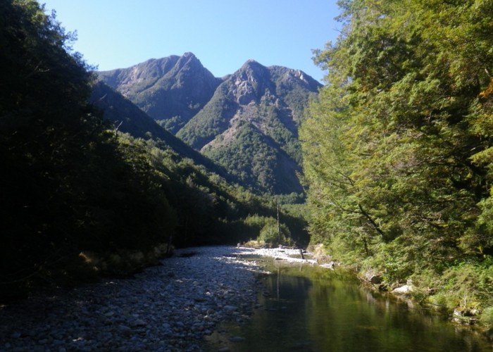
Paddock stags roar challenges as I leave Longford and head 2km further east along the highway to the bridge. Roar again as I return down the far side of the river. The Buller flows silently below in a shallow limestone slot – sidestreams forced to cascade down vertical walls, cutting polished U-shaped half-chimneys for themselves as they descend. An anglers’ access opposite Longford offers campspots, as well as access to the river – but belly full and rested the side-trip into town seems well worthwhile. Finally – 12km after leaving Murchinson - we pass 200m from its campground on the opposite bank of the Buller, and swing north up the Matiri.
The low valley is farmed, fenced paddocks a mix of green grass and rushes: home to small dairy herds. Crossing later to the narrower west bank, fences become ramshackle. Piles of agricultural junk litter paddocks, land seeming on the point of abandonment. Then, broad flats open again, paddocks green and pristine. Even the power poles march a tidy straight line up the flats, the road winding between immaculate fences. We reach the last house, the last power pole, the last of the gravel. A gate: fierce signs informing us that this is a workplace and that the following hazards exist ... A further kilometer of dirt road leads to a DOC carpark, three more on 4WD tracks to the forks to the East and West Matiri, where finally tramping begins. 26km of road walking – enough already!
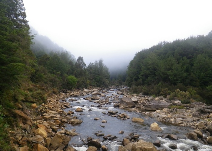
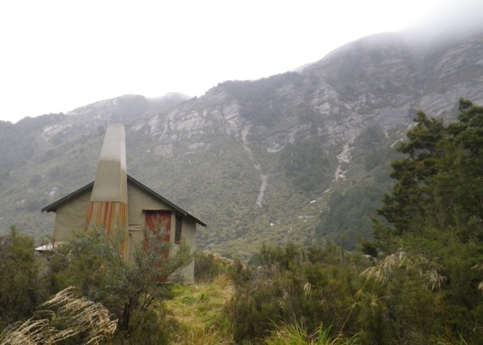
The West Matiri riverbed is huge: clean white riverstones, 200m wide bed. Yet a small stream is all that flows down it, hugging the far bank – hopped across on smooth-polished rocks. Clambering up the far bank we discover yet more roadbed, this one long abandoned, overgrown. Benched into the valleyside, it provides easy travel upriver, a lone slip forcing a detour onto the rocky riverbed. Scrub and bramble hide long-abandoned paddocks on intermittent flats. A kitset garden shed on a concrete slab is the only new structure we pass – officiously titled ‘West Matiri Emergency Shelter’. Iron walls not meeting the concrete floor, no furniture inside - it seems deliberately built to attract only the desperate.
The roadbed leaves flats and winds up the natural dam that holds back the lake. Beech forest tall and mature; the slip that formed it clearly long in the past.
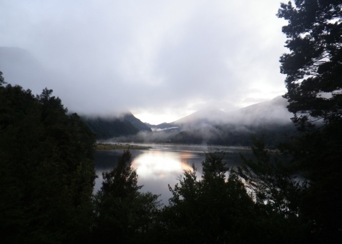
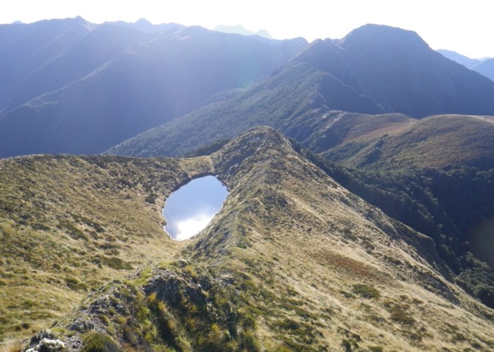
The hut arrives soon, long before I expect it - tucked into the hillside on a bulldozed platform. A picnic table outside has views upriver - over the still waters of Lake Matiri to the broad flat valley beyond. Waterfowl of all colours and sizes dot the lake; some towing V’s across the mirrored surface; others diving, making targets of concentric rings. A class demonstrating interference patterns as their contributions collide, all squabbling raucously. A thousand sandflies descend as I admire the scene. I retreat hurriedly inside, emerging only for a hurried wash under the tap – much to the sandflies delight. Matiri Hut is large with 8 bunks – but homely, warmed by one of those wonderful Oregon potbellied stoves. Once you wipe the remains of the sandflies from the windows, you can admire that same view from within: watch the valleysides darken, the lake turn pink, then bruised purple as the day ends. Light fading until the landscape is just a black silhouette against a tapestry of stars.
Longford -> Matiri roadend
The road bridge is 2km east of Longford along the highway. 16km of road walking follows along the Matiri Valley Road, crossing to the western valleyside at the bridge, to reach the DOC carpark at the 2WD roadend.
Matiri Roadend -> Lake Matiri Hut
3km of walking along a 4WD track from the carpark takes you to the West Matiri. The riverbed is huge, but the river small and easily crossed in normal flows – rock-hopping or knee deep. In flood the river is impassable.
Scramble up the far bank at the forks. An old roadbed continues up the valley, passing the West Matiri Emergency Shelter – for those caught by the flooded river. Interrupted in one spot by a slip where you must detour onto the rivedbed, the roadbed runs all the way to Lake Matiri Hut.
Day 10: Lake Matiri Hut – Hurricane Hut
Ducks still practice their alphabet on the still waters of the lake as I leave Lake Matiri Hut and head upriver. We push though tall thistle and tutu on the flats; sidle, undulating on beech faces, stepping over, through, into hollows formed by a low labyrinth of roots. The river lurks below, deep, silent and slow; winding between tall crumbling mud banks. We sidle, start to climb. The river changes: its voice a roar as it churns down a boulder bed; water barely visible between overgrown rocks – a child in adult’s clothing. The track climbs and falls – diversions over unseen slips.
We’re back on the valley floor: marshy tutu flats. The river again silent; flows swiftly and purposefully on a bed of sand. Then, finally: McConchies Hut. A cute four-bunker warmed by an Oregon stove; looking over a small marshy clearing to a wall of scrub beyond.
The track has been tiring: sidles steep and slippery, slowed by frequent old windfall; the valley floor wet, marshy, tangled with tall tutu; not the easy valley-floor stroll I’d expected. The track marking: generally good, then disappearing completely just when you need it the most. But then I’m tired, exhausted, and fear that fatigue may be colouring the experience. No matter: push on to Hurricane Hut today for a well-needed rest day tomorrow.
Upstream of McConchies the mood is unchanged: river silent and swift, glittering crystals of sand; track undulating the steep beech-green valleysides. Then, two kilometres above the hut, everything changes. A huge white scar dominates the western valleyside: 1000m x 300m x 100m of hillside – gone - deposited in a bouldery heap on the valley floor. Lichens and small scrub barely beginning to colonise the debris: a recent, fresh wound. The track scrambles, winds its way over the debris, climbing high above the valley floor. Looking east: the same story is repeated again and again. The landscape – an unbroken green canopy of beech downriver – is here raked by fresh white scars. ‘Earthquake-damaged terrain’.
Two kilometres above this first slip, the valley forks. The dry western fork climbs steadily up boulderfields; low shrubby toetoe and tutu well established. Two kilometres of tangled climb follows, winding blindly between tall boulders and scrub, before the track finally cuts north – climbing the valleyside to the ridgeline. Looking back, the reality of what we’ve just crossed is revealed. Upriver the valley is a typical V: dense unbroken beech forest, steep valleysides, limestone bluffs above. But, where we climbed out, a dam of boulders some 100m high blocks the entire valley; tumbled from another massive white scar above. The entire V of the valley floor is gone, buried by the fall. Looking east: the same story repeated, though the outcome is different. The East Matiri is blocked by a smaller fall; this time forming the dam for a many-fingered lake – tree trunks still standing, surrounded by water, witness to its recent origin.
After the scrub-scramble of the climb, the ridgeline track is a luxury: a broad mossy pathway winding through beech and fuchsia. A stag roars in the forested valley below; receives no response to his challenge. A minute later: roars again. Giant hoofprints follow the track, cut into moss, deep slots in the mud; a wallow is churned to milk-chocolate, musky odour lingering still.
We leave the ridgeline, descend into a giant tussock clearing - an amphitheatre of white limestone bluffs. Into beech again: drop into a creek-head. The creek takes us east, broad beech terraces leading back into the ‘wet’ Matiri. No longer a swift river, flowing silent over sand: the small creek roars its descent; shallow channel cut into the underlying boulder-face. We climb beside it amongst the trees, treading silently on the accumulation from years of leaf-fall.
The forest ends at the crest. We stand atop a centuries-old rubble dam; the valley beyond long filled-in with sediment: marshes and tarns, yellow-brown with tussock and rushes. The gentle lower slopes: bouldered, white-blue with flowering shrubs. Above: pancake-stacked bluffs of white limestone, grey-stained streaks revealing where water sometimes flows. We meander, seemingly aimlessly between boulders and marshes, heading generally upriver; cross the now-small Matiri in a single leap. Huricane Hut sometimes visible, sometimes not, finally reached: tucked against beech at the base of the eastern slopes. Cloud covers the tops, a cold mist of fine drizzle setting in: a wash in the stream takes more motivation than normal. But soon, tucked clean and dry in my sleeping bag, watching the rain sweep the limestone faces, warmth returns and all is right in the world.
Lake Matiri Hut – McConchies Hut
3hr. The old roadbed drops to the valleyfloor and ends. An occasionally-poled route leads up river flats through thistle and tutu – wasps are apparently a real hazard. The track alternates between sidling the steep valleyside and pushing through marshy flats all the way to McConchies Hut. The sidle sections are generally well-marked, occasionally cut, and in places windfall is a nuisance. One brief steep climb is required to bypass slips, and is not well marked.
McConchies Hut – Hurricane Hut
4hr. After brief flats the track resumes sidling the western valleyside, climbing 100m over a spur before descending nearly to the river. A massive slip has taken out the valleyside, and the route winds and scrambles over the resulting boulderfield, marked with cairns. Back in the bush the track is good up to the East/West (wet/dry) Matiri forks. The track is poled up the dry West Matiri, climbing through a scrubby boulderfield. Woody vegetation has been regularly cut, but the track soon wills with tutu and toetoe and so this section is slow through waist-high scrub. After 2km the track swings north and climbs to the ridgeline. An easy, well cut, well marked ridgeline route follow before dropping to a large grassy clearing. Follow the eastern side of the clearing north (not well marked) and find orange markers on the bushedge beyond. Again, a good cut marked track leads through beech, dropping into a creekhead. Follow the creek downriver, crossing a few times before ending up on the northern bank. The track soon diverges from the creek, so don’t be tempted to follow the open creekbed. The creek is low (ankle deep) in normal flows, and crossings are not well marked. The track swings north and climbs adjacent to the East (wet) Matiri over a beech-covered boulder dam and into broad marshy flats above. The track follows the western valleyside past a lake, some distance upriver, before crossing to the east just below Hurricane Hut. Parts of this section are not well marked or well defined on the ground and it is easy to loose the track. Hurricane Hut is tucked against beech forest on the eastern valleyside upstream of the major confluence, as shown on maps.
Day 12: Hurricane Hut – Helicopter Flat Hut Stone Hut
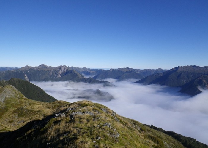
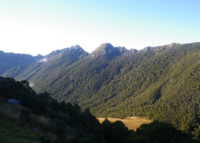
The track climbs steeply behind Hurricane Hut, well marked, beech mature and open. Soon, the gradient lessens; beech forest giving way to clearings of rush and toetoe - a bog on a twenty degree slope. We ascend, passing between beech forest and clearings. A bare shoulder looks out down the valley: lake Jeanette today blue and inviting in the morning sunshine. Beyond, a lake of cloud builds up behind some imagined dam. We ascend, leave beech behind, exit onto tussock tops. A biting southerly greets us, only just offset by the heat of the climb. Following poles, we climb in the shadow of the peak. Finally, ahead: a warratah sports a halo of light, stands backlit by sun. I step onto the summit, into sunshine; admire the view, briefly. Quickly drop pack and rummage for layers warm clothing. Soon after: rummage for more. The morning sun: no match for that bitter southern wind.
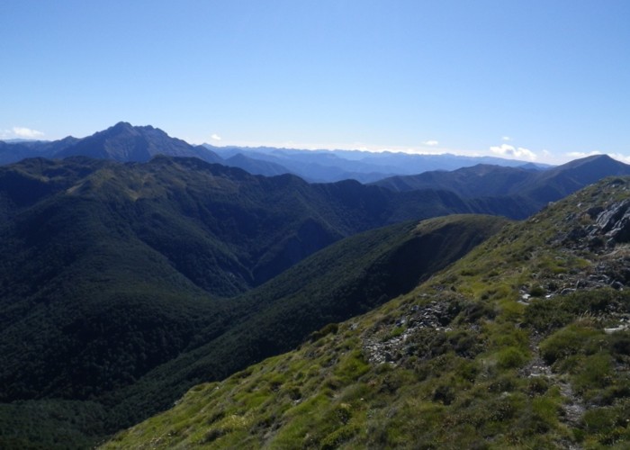
To the south-east: grey, dominating, lies the limestone massif of Mt Owen. A barren, tableland; cut-into, carved, eroded by valleys; standing tall, flat-topped above beech forest below. North-west of us, silhouetted against the morning sun – the towering outline of Mt Patriarch. Standing tall: unmistakable, though I’ve never been close before. To our north: the sinuous sweep of the Matiri Range; tussock-clad at first, rising to grey knife-edges of limestone as it climbs. Twelve kilometres on top of the world: that’s our tramp for today.
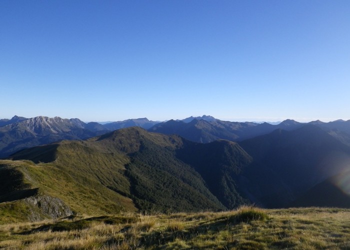
The walking is easy; views take your breath. Kilometer after kilometer of undulating ridgeline; peak after peak – each opening up new vistas, new valleys into which to peer. We pass a small tarn after three kilometres – a sheltered spot where many parties camp. Drop to scrubby saddles of stunted beech – rough track bashed for use through the scrub. Climb onto flat limestone peaks beyond. Broad tops narrow to knife-edge ridgelines, widen again to broad summits at the next peak. A faint ground trail gives guidance – where to persist scrambling-on, where to drop-off and sidle the face. A last steep scramble takes us to our final, highest peak: Nugget Knob. The full sweep of the Arthur Range is at last revealed; light glinting beyond: ocean, Nelson Bay. Haze blurs the west: the absence of horizon the only hint of land ending, of the Tasman beyond, of my destination.
We follow the tussock tops north to their conclusion, swing west at the bushedge, dropping steeply through beech. Orange markers lead again, a rough ground trail down a barren forest floor. Wide cut-tracks and a forest of signposts greet us at the Wangapeka Saddle. Five kilometres west to Helicopter Flat Hut. But I find myself unwilling to accept that tops travel is over: make a spontaneous call. I’ll drop east to Stone Hut today; tomorrow: one last morning on those magnificent ridgelines, a final feast, heading north over the Biggs Tops, before I finally accept confinement to the valleys as I drop west to the coast.
Hurricane Hut to Wangapeka Saddle
A cut, marked track climbs from Hurricane Hut to the bushedge, poled beyond to the summit of pt1442. An unmarked route heads north along the Matiri Tops – a faint ground trail present in places. A small tarn is reached after 3km. A small campspot at its northern end is sheltered from the southerly but exposed to its north. Larger campspots to the west are exposed to all winds. This is the only reliable water source on the ridgeline.
From the tarn, drop east with the ridgeline to a saddle of stunted beech. Good sidling in open beech is available just north off the ridgeline. Climb to the next peak, then drop to the saddle beyond. This is scrubbier, but a rough track has been bashed through the scrub near the ridgeline, finally sidling the western face in open fuchsia before emerging onto open tussock. North of pt1431 the ridgeline becomes narrow in places, but generally you can sidle just off the western side with rock to hold onto. The climb to Nugget Knob crosses a brief rocky slip – exposed to falls. A good route exists, so have a good look before committing yourself to anything dangerous.
From Nugget Knob, descend west then swing north with the ridgeline. At the first saddle, at a cairn, drop to (or near to) the bushedge to the west. Sidle the bushedge north until you are 50m past a large bite out of the rocky ridgeline, before climbing back to the now-broad ridge. Continue north until you hit the east-west bushedge at the end of open tops. A small orange triangle at the western edge of the clear area marks the start of the track to the Wangapeka Saddle. Descent the faint but well marked steep track to the saddle. The junction with the Wangapeka Track is obvious, and marked with a signpost.
Wangapeka Sadde to Stone Hut
Follow the Wangapeka Track east for 3km to Stone Hut. The track is benched, cut and marked, though a little rough underfoot. Riverbed sections are marked with cairns. The only stream crossings were below boot depth when I visited 24 hours after heavy rain, though they could flood during heavy downpours.
Day 13: Stone Hut to Stag Flat Hut Taipo Hut
From the Wangapeka Saddle, a good track climbs gently north towards the Biggs Tops. The tall beech forest is soon left behind, the forest floor changing from soft carpets of beech leaves to twisting red streamers of fuchsia bark. Emerging from the bush, the track sidles just above the bushline; but, eager for views, we leave the track and climb onto the tussocked ridgeline above.
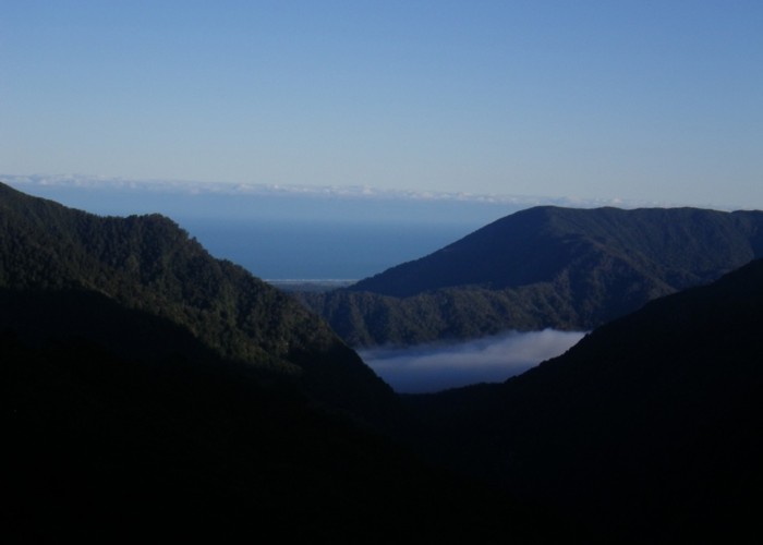
Beyond, the Karamea is a broad sea of cloud. And inlets lapping against beech forested slopes; long fiord-like tongues reaching far up side valleys. The Arthur Range to our east: a black silhouette against the morning sun. We wander west along a gently undulating ridgeline, looking down on this new world. All too soon we rejoin the track at the saddle, drop north into beech forests, descending into that sea of cloud below.
The track is sleep, slippery in the misty-damp. But the cloud-layer proves thin, and we soon drop below it; descend rapidly to reach the valley floor. Trevor Carter Hut sits in a warm north-facing clearing, waiting for the sun to break through.
We leave the hut after a quick smoko; the cloud finally clears. Black bluffs frame the northern valleyside; sun reflecting off brilliant white rocks on the riverbed below. The tunoff up Lost Valley is 200m from the hut. An easy, broad, cut track swings right up the Taipo – but our signpost points straight on towards a jungle of toetoe. We push through, shaking the morning dew of each stem as we pass; drop into a stony riverbed and boulder hop up it for fifty meters; to where a broad, cut track magically commences. An easy walk follows, leaving toetoe and scrub behind as we enter tall beech draped with moss, shadowing the river as it climbs towards the low pass. An oil-black lake shimmers through the bush, its dark surface framed by white toetoe radiant in the sunlight.
The descent south from the saddle is far steeper; beside us water tumbles in shadow down faces of black rock. We drop quickly; reach the open, rocky riverbed; step back into the light. Helicopter Flat Hut sits warm, in sunshine, on the opposite bank.
Leaving Helicopter Flat Hut we sidle into a bichromatic world. The platform of the track: soft, brown with littler, decaying accumulation of years of leaf-fall; a crinkle-crisp topping of fine fresh beech leaves. This brown line cutting through a green moss-covered world. We sidle the southern valleyside; a ribbon of light glinting through the tree-trunks, below us to our right. The river: weak tea, flowing over shining white marble; dropping slowly away from us, it’s chatter fading to a distant whisper; now glimpsed only occasionally through the trees.
We round a bend, swing west. A faint breeze brings warmth. Light changes: the dark cold green-blue of our shaded forest transformed as sunshine finds fiery oranges and browns in the mosses and lichens. Silent footsteps on damp leaf-litter become the crunch of dry leaves and bark underfoot. To our right, the tight dark V of the upper Karamea is gone, replaced by the broad sunlit expanse of the Taipo. A flat shoulder of land contains the remnants of a life; picks, shovels, bottles - the last remains of the roadbuider’s hut: Brough’s Tabernacle.
The track descends gently, still a narrow bench carved into the hillside; I relish the newfound warmth. Eventually we meet the valley floor. A swingbridge takes us to the northern bank, crossing slow-moving pools framed by beech forest and limestone bluffs.
The track climbs unhurriedly with the river: a maze of tree roots and rocks. Moss is replaced by ferns: low knee high crown fern obscures footing, tall fern trees illuminated by shafts of sunlight through the canopy high above. Excited, eager: I sense the proximity of the coast; the first hints of that vigorous verdant growth. The dry clean beech of the Nelson Lakes has been our companion for far longer than I’d expected.
Taipo Hut sits damp, cold, shaded in its small clearing on the northern valleyside: looking up to the saddle from where it awaits its daily two-hour ration of sun.
Signs on the wall, black with mould, warn that Stag Flat Hut has been removed, replaced by an emergency shelter sleeping two. Images of that kit-set shed up the Taipo come to mind, replace the warm two-bunk hut I’d expected. I procrastinate, undecided: a bed in this solid, damp hole; or push on seeking views and sunshine, and risk a night on cold concrete floors.
Cloud moves in, and I stay.
Wangapeka Saddle to Trevor Carter Hut via Biggs Tops
A signpost at the Wangapeka Saddle marks the start of the Biggs Tops route. A cut track climbs to the bushedge, from where a poled route sidles west into a basing and then north to the saddle at its head. Alternatively you can climb to the summit and follow the ridgeline to the saddle.
From the saddle poles sidle onto the northern side of the ridge through tussock basins until beech rises to meet the tops. The start of the track down was not clear when I visited (2016) but nosing around down into the beech from the last marker pole, I soon picked it up. The cut track is well marked and descends very steeply to the Karamea below: initially on a spur; later sidling west and descending a damp gully; finally climbing back east onto the spur and into scrub. The track ends at a signpost 100m upriver of Tervor Carter Hut,
Trevor Carter Hut to Helicopter Flat Hut via Lost Valley
200m west along the track from Trevor Carter, the Lost Valley route to Helicopter Flats is signposted Follow markers through tall tutu and toetoe, dropping into the Lost Valley Creek. 50m upriver a marker shows the point to climb out on the eastern bank. A good cut, marked track runs from here over the saddle. The climb is gentle, and the descent steep. The Karamea must be crossed at the end of the track: knee deep in normal flows, but easily floodable after rain. Helicopter Flats Hut is 100m downriver on the opposite bank.
Helicopter Flats Hut to Taipo Hut
A good sidle track heads downriver from Helicopter Flats Hut. The track is cut, marked and benched. Three kilometres later the track swings west and sidles above the main Taipo Valley. A signpost marks the turnoff where the Saxon Falls track drops east to the Taipo/Karamea forks. Continuing west along the main benched track for two kilometres also takes you to the Taipo valley floor where a swingbridge crosses to the northern bank. The good track continues, rougher underfoot with roots and rocks, climbing gently for 5km to reach Taipo Hut, which is on the track. There are no unbridged river crossings on this section. Times for this section of track seem to have been underestimated by DOC – I’d add 30% to the DOC times to make them comparable with quoted times for other nearby routes.
Taipo Hut to Tasman Sea (Little Wanganui)
We walk through dew-laden grass and fern, drop to the river and cross it on a springy suspension bridge. On the far bank the ground is dry, leaves crackling underfoot. The track soon starts to climb; bush still dark, shaded by peaks to the north.
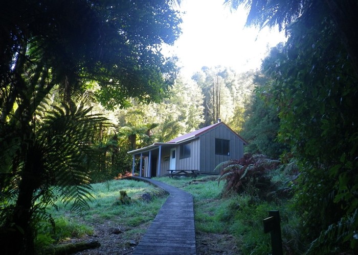
Ahead, far above: a golden glow. An improbable tussock flat, perched below the saddle 300m above the main valley floor, radiant under the morning sun: Stag Flat. Full of morning energy, we soon emerge from the beech into its sunshine. A tidy two-bunk hut sits on the bushedge, looking west out over tussock and sunshine to bluffs and waterfalls beyond. Inside the hut is cozy: steel table, two bunks with mattresses, walls lined and lagged. I lament my cold, damp, dark night in the valley – with I’d had the courage to believe that this gem really did exist.
The track swings north skirting the clearing; climbs steeply but quickly to the saddle 200m above; exits the beech as it crests onto the tops. Beyond, a basin of tussock and white rock holds a sky-blue tarn. A tent pitched on the far shore awaits the arrival of the morning sun. That line of warmth, creeping its way down the eastern valleyside, still an hour away from melting frost from tent-canvas.
A short climb over the rock-dam, and down into a second basin beyond. This one scrubby, its lake dark green: cold and uninviting. The well-worn trail drops rapidly into the bush below, down loose white rock-scree and mud. With a little care, we arrive at the valley floor: mostly unharmed.
The river crashes and roars down a steep rubble bed; drops with West Coast urgency: so many meters to loose and the sea oh-so near.
The track, now formal and benched, leads downriver: sidling and dropping between wooded flats and terraces. Mirroring Stag Flat Biv to the south, a tidy two man ‘shelter’ sits in a small clearing looking up at the cirque of valley-head bluffs. Further on still, evidence of the 2014 cyclone Ita starts to appear: sections of valleyside with every tree fallen, surrounded by puzzlingly untouched forest; river path changed completely; bush slopes swept away, now crumbling boulder-cliff walls. In places the track winds between windfall, in others becomes a gorge saw-cut through a hundred fallen trunks.
The valley broadens. Beech still dominates the faces, but the valley floor changes: a menagerie of broadleafed trees covering the flats; fern trees growing in shade beneath their canopy. Sheer, gorged valleysides suddenly gone; replaced by low, gentle slopes. The river now broad: spends the last of its alpine energy over white river rocks. A clearing appears ahead on the now-broad valley floor: Belltown Hut at it’s rear.
===
Walking down the track from Belltown I’m suddenly aware we’ve left the mountains behind. Tall valleysides of rock, tussock, scree and beech have been constant companions since the first day of our trip; now I feel their absence. The Little Wanganui flows out onto the brief coastal plain: dotted with low hills – scattered echoes of the peaks we’ve left behind. The track feels as if it has been a road sometime past: a broad cambered bed of stone and gravel in places. In others, cut away by the shifting river, a narrow muddy bench across low river-carved faces. We soon leave beech forest behind. The flat northern valley floor has been farmed in the past: vegetation now a riot of regeneration. Fern trees compete with every broadleafed shrub and tree: eagerly recolonise. A tangled knitting of supplejack, lawyer: vines of all sorts joining the race for light. And green: a verdant fluorescent green, after the dark subdued shades of the mountain forests.
South, across the river, another story is told. One of devastation: a once-tall forest reduced to sticks and firewood. A tumbled, tangled mess of trees become kindling, tall lifted-up root-pads almost all that’s left standing. Even the few standing trees are devoid of life; bare-barren spars awaiting the next storm. Rutted white sandy slips, fresh bare rock faces, shining where continuous canopy so recently stood. The devastation of cyclone Ita. There was much fuss made over the issuing of permits for ‘prevision extraction’ of fallen hardwood in the aftermath: concern about damage by loggers to still-standing trees. But here, at least, it’s hard to see what could be salvaged; or, come to that, what’s left to damage.
The regenerating vegetation on the north bank, lucky perhaps to have been cleared in the past, continues unaffected. Occasional scattering of fallen timber mark, perhaps, what were lone standing trees: obstacles through which track-clearers have had to toil, but not the landscape-changing devastation seen to the south.
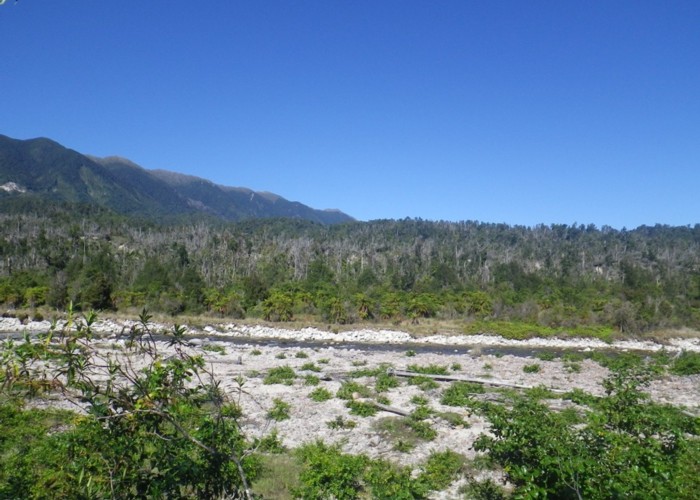
The track becomes a definite roadbed, passing through bright grassy clearings scattered with fern trees. We veer north from the river into a broad flat basin – small creeks cross the road flowing in every random direction. We cross a low pass, maybe thirty meters above the plain; drop back to the main river one last time. The mountains rally for one last gorge: 80m deep, a shallow imitation of what came before, the river barely noticing amidst its broad rocky bed. Old fence-line appear, half-hidden in the regrowth; an old car – abandoned; the roadend.
Fragrant bluegums: a long, straight avenue flanking a road of white gravel. Nine kilometres to the coast. I strain at my leash, at the limits of my body, eager to stand on white sand with nothing but the Tasman beyond. An old, bearded Dutchman ambled towards me down the road; passes comment on my haste; feels no need to quicken his own. His clothes: old, worn, stained, returning to nature; just as the roadside paddocks return to scrub and swamp.
Gums and scrub end, leaving the road a lone white line stretching into the distance. Flanked by green dairy paddocks; brown cattle drift - a distant low cloud in their midst. A final low range of hills terminate the plain; a last low pass; anticipation …
A kilometre of low swampy plains; paddocks falling and rising as if in ridge-and-furrow, an alternating sequence of green grass with dark rushes and reeds. And beyond … a blue sea: colour of the sky, stretching away until some indiscernible line where the two must meet.
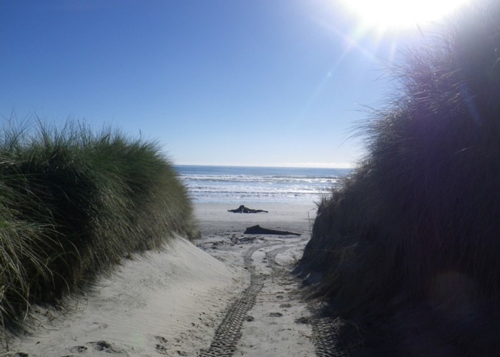
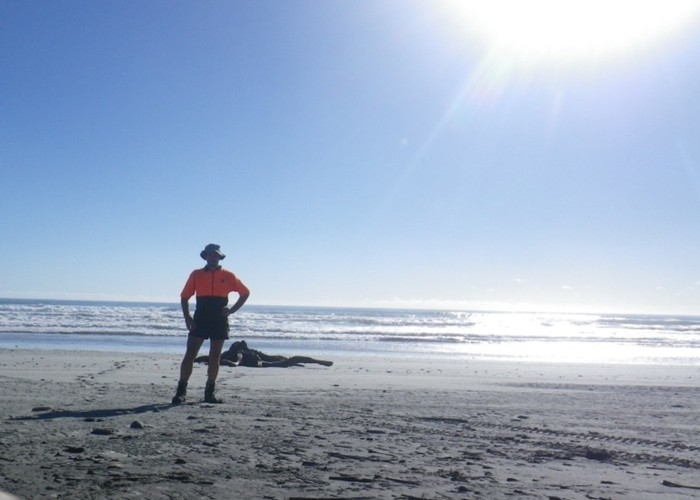
Through the township of Little Wanganui, and onto the beach. White sand, ocean: just as in my dreams. A lone stump of driftwood: a black silhouette to provide contrast to the scene. Small white waves wash silently onto white sand. And beyond: only sea.
===
I walk back through the single coastal dune towards the Little Wanganui Hotel; think of how it feels to be here. I surprise myself: feel a sense an uplifting, genuine elation at a goal achieved, at a journey complete. Unexpected: for such endings usually seem disappointingly symbolic, an anticlimax tinged by sadness that the journey is over. Instead I raise my hands in a silent, happy cry of joy.
===
But what did it all mean? All the planning, the time, the effort expended – surely it had a purpose, some greater meaning or learning.
For me the key memory is one of landscape changed, of the “devastation” wrought by three forces: storm, earthquake and man.
The land levelled by cyclone Ita: thousands of hectares of great old-growth forest gone in a night. Yet a new one already busily establishing itself: that verdant growth of the West Coast, fighting already to be first to reclaim. The devastation spectacular in scale and power; but accompanying it that underlying sense that nature’s cycles work thus.
Further back in our journey, the scars of the 1929 Murchinson Earthquake are still raw; the landscape changed in places beyond recognition; vegetation still struggling to reclaim, heal - even eighty years on. Yet, comfort is there too for those who need it: older devastation, now long healed. Lake Matitri, Lake Jeanette, held back behind forest-covered dams of past rockfall. Tall beech trees, moss-laden, covering once-bare white rubble; contours on maps the only indication of the scarred valleysides it left when it fell. A journey through that country was a spectacular demonstration of the immense force of earthquakes: their ability to change the landscape; but also the ability of nature to heal, its tendency always to return to the status quo.
And man? Those long days through Clarence and Molesworth: barren soil so robbed of fertility that it can barely support even hieracium. Day after day with barely a single native plant seen: endless hills of dirt, rosebriar, bugloss and hieracium; valleys - ribbons of willow. Where in that landscape should I find the message of healing? Where, amidst that exotic scrub, is the evidence of the self-repairing cycle of nature? Maybe I saw just what I sought, what I’ve been taught to expect: saw it all through weed-sprayer’s goggles. But, try as I might, I found none. What I saw was a landscape changed forever: not pulling back to a past state, not healing; but striding unwaveringly towards an exotic future. The only comfort offered: to accept that change too is part of nature; that briar, bugloss and willow are native now.