French Ridge
Mount Aspiring National Park, Te Wāhipounamu - South West New Zealand World Heritage Area
- 2 – 4 days return via same track
- Medium
A steep climb to the snowline in the West Matukituki.
|
Walking time
|
2 – 4 days
13 hr – 15 hr
|
|---|---|
|
Distance
|
28.0km |
|
Type
|
Return via same track
|
|
Grade
|
Medium |
|
Bookings
|
No bookings — open access
No — open access
|
|
Starts
|
Raspberry Flat car park, Wanaka Mount Aspiring Road end. Follow the main road westward around the lake from Wanaka. There are several fords near the road end which can rise and block vehicle exit. |
|---|---|
|
Maps
|
NZTopo50-CA11
|
|
Altitude
|
370m
–
1,463m
Altitude change 1,093m
|
This walk leads over the gentle flats of the Matukituki River West Branch before climbing steeply off the valley floor to the alpine hut. From here, there are sweeping views of the head of the valley and nearby Mount Avalance and Rob Roy Peak, although Aspiring itself is hidden from view. While you can do the entire trip in just two days, you could make the climb easier by staying the first night at Aspiring Hut or by establishing a basecamp on Pearl Flat below French Ridge.
Although this route provides climbing access to nearby Mount Aspiring, trampers cannot venture far beyond French Ridge Hut before encountering dangerous snow conditions. The climb up French Ridge can be slippery and hazardous in poor weather conditions.
From the shelter at Raspberry Flat, an old farm road leads up the valley, passing the swing bridge to the Rob Roy Valley after 20 minutes. The easy walking across river flats continues as the valley bends northward. Eventually you pass the locked Cascade Hut (NZAC). Aspiring Hut is located on a low terrace a further 30 minutes on (2-2.5 hours from the car park).
Aspiring Hut is impressive: constructed from local stone and opened in 1949, the hut features a wall of windows facing up the valley. Aspiring is often hidden by cloud, but can be glimpsed from here leaning over the slopes of Rob Roy Peak. A camping area and shelter is located nearby. Sandflies are pesky around the hut. Southwest of the hut, the route down from Cascade Saddle drops steeply off the tops. A short walk up this track affords good views, although the route becomes extremely dangerous near the top.
Beyond Aspiring Hut, the track enters forest and winds to a swingbridge across Cascade Creek before returning to flats. A second forested section and a second swingbridge is followed by a gentle climb before dropping back into the open at Shovel Flat. An impressive waterfall on the left descends on the Christopher Johnson Glacier in steps of 163 and 87m. A final brief forest section leads to Pearl Flat (1:45 from Aspiring Hut).
Continue along the true right bank of the Matukituki to the confluence with Liverpool Stream. You can ford Liverpoool then the Matukituki here, or you can cross bridges. The Bridge over Liverpool is just a few metres upstream, but the bridge over the Matukituki is further up the valley and will add another kilometre to your journey.
From the Matukituki's true left bank, a marked track to French Ridge Hut leads into the forest. This track climbs directly up the hillside, becoming a hand over hand scramble up rocks and roots, and the 3 hour, 930m climb begins.
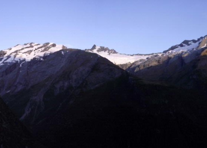
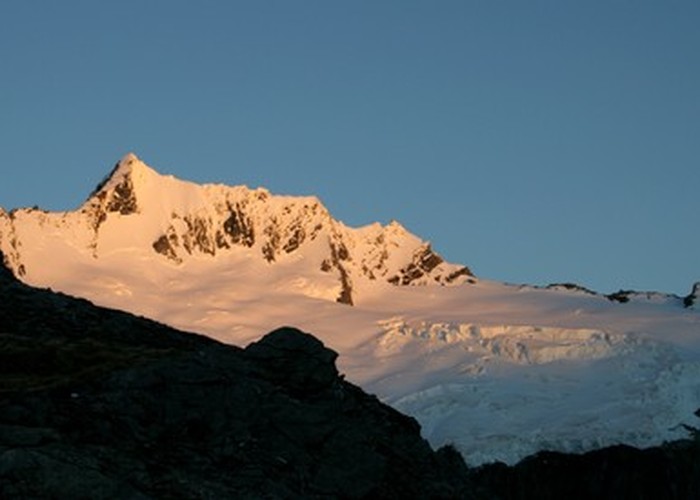
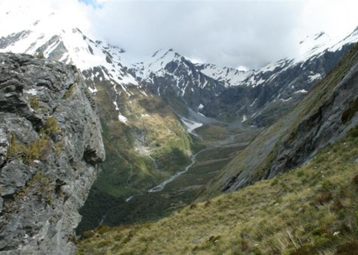
Eventually the beech forest lightens and becomes scrub. Across the valley, the orange Liverpool Hut and its satellite toilet are visible on a high tussock plateau. If it looks like a long climb to that hut, French Ridge Hut is much further! The halfway mark is just below Liverpool Hut (when you are level with the hut, you are 4/7 of the way up the ridge). As you climb, a few small tarns are passed and impressive views of Gloomy Gorge to the right open up. Mount Avalanche and its apron of glaciers head the valley. Avalanches often crash down the sheer rock walls to the basin below, where the stream takes up and winds beneath the rugged slopes of Rob Roy to the gorge, where it is lost from sight.
The track continues to climb enthusiastically up the ridge to the hut located on a small plateau near the lowest of the summer snow. The balcony is a good place to watch the antics of kea vying for position on the top of a nearby cairn, to watch avalanches, and to contemplate not having to walk any more.
The return journey down French Ridge is not a lot quicker. You may save 30 minutes.