Waitakere Dam Walk
Waitakere Ranges Regional Park
- 30 min one way
- Easy
- Waitakere Tramline Walk leads off on the eastern side of the dam. This track leads off the access road just up from the dam. Due to a long tunnel closed to walkers, these tracks do not form an effective circuit.
- Fence Line Track leads off in two directions on the far side of the dam. Take the track to the left to wander through easy forest next to the reservoir. Fence Line Track is part of the Montana Heritage Trail.
- Just before the dam is a very short side track called the Cascade View Track. This is rough and perhaps unmaintained, with some sort of a view down the valley below the dam. There are far better views from the dam itself.
A sealed private road to the dam, with good views and a large kauri along the way.
|
Walking time
|
30 min |
|---|---|
|
Distance
|
1.4km |
|
Type
|
One way
|
|
Grade
|
Easy
Sealed road descends all the way. Grades explained
|
|
Bookings
|
No bookings — open access
No — open access
|
|
Starts
|
Waitakere Dam car park signposted on Scenic Drive. |
|---|---|
|
Ends
|
Waitakere Dam. |
|
Maps
|
-
|
|
Altitude
|
200m
–
336m
Altitude change 136m
|
This walk follows the private access road to the Waitakere Reservoir and Dam. The road has a locked gate, but is open to public walkers during daylight hours. As the reservoir collects drinking water, it is not open for swimming or water activities. This walk connects up with the greater track network including the Montana Heritage Trail.

From the car park, follow the road down through a forest of kauri, rimu, rewarewa. A large kauri is marked along a short track to the side.
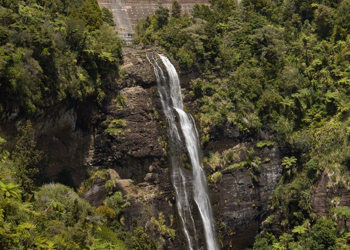
A toilet block is located nearby, with steps leading down the face of the dam. Here, an old service tramline heads off into the forest, although this section is closed to walkers. The track crosses the outlet and winds through light forest to the far side of the dam and the Montana Heritage Trail junction. Left from here, you can drop onto a gravel road and head back across the top of the dam. There are good views down-valley.
The dam is actually built at the top of the 95-metre Waitakere Falls. There are no views of them from here, but you can see them by taking the Waitakere Tramline Walk for a few minutes.