
There are six great Canterbury rivers: with glaciers in the headwaters, snow melt and swift flows, sharp gorges, braided gravel in the middle sections, large tributaries and huge sweeping mountain sides. One of the biggest is the Havelock.
Erewhon (North bank) and Mesopotamia (South bank) stations are the road ends, here three big rivers come together to make the Rangitata. The Havelock is the southern most of the three headwaters.
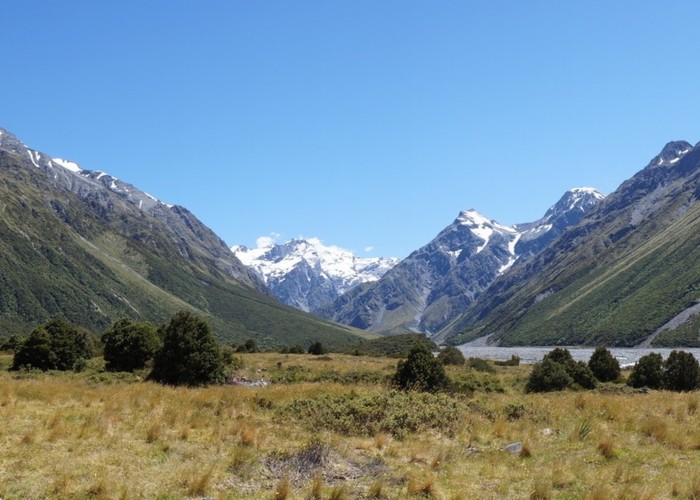
The valleys are all huge. It takes a while to get your eye in to appreciate the scale of the place - at the car park the braided river bed of boulders and gravel is over 4 km across and the peaks of the Two Thumb range in full view on the far side rise nearly 2000m from the river. From the Mesopotamia carpark on the TR bank it is 37km to the glaciers on the main divide. For you lucky people based near the Tararuas - imagine Kaitoke as the road end and walking to Mitre Flats, in one valley.
Its open country, there are stands of bush in the gullies and lots of scrub but even more tussock and scree and crag; and up valley there are snow fields and glaciers. In winter all the peaks are snow covered and after fresh falls the valley floor is too. In summer the NW wind can blow you off your feet and full sun protection can be essential, in winter the frost can freeze water tanks solid. Storms or extra snow melt at any time of year can turn the rivers into churning grey oceans, a kilometer across of exploding pressure waves.
But on a recent trip in January the sun shone gently every day for a week, and on most days I had 30km of grand alpine valley to myself.
Most people heading up the Havelock on foot start from Erewhon Station on the north bank. From here, first you have to cross the Clyde - never underestimate any river, especially in this region, but in a dry spell there are normally reasonable crossing options just above the junction with the Havelock. If you then also cross the channels of the Havelock here you can head upstream on the True Right and that that is what most people will try and do.
These first kilometers are mostly out on the open river bed, mostly gravel and boulders underfoot interspersed with shorter sections on 'islands' of grass and riverbed plants. Efficient travel is a sometimes subtle mix of heading in a straight line for the furthest away goal and meandering to find the best travel. Straight lines are usually faster and the meanders are easier on your feet.
If you intend to go to Growler, Mistake Flats or the Forbes river, you can stay on the TR (true right) and possibly even enjoy some of the 4wd track that is rather far from the river on the tussock fans and flats. If you are heading further up the main river it's faster to stay out in the middle and after Carney's Creek look to ford the river to the flats below Curtis Hut. Enjoying the easy travel on these flats effectively cuts the next corner at Darkey Jims Bush. If you ever thought that Canterbury valleys don't have bush spend some time here at Curtis and explore the surrounds.
Above Curtis/Mistake Flats the river is usually in one concentrated channel.
Below St Winifred's the river flows hard against bluffs cutting practicable access from the TR. So it is easier to stay on the TL until opposite St Winifred's Hut and is often pleasant walking. If the river is low - a straighter line and a double crossing of the main channel will still avoid the TR bluffs and take you to the same point opposite St Winifreds saving perhaps half an hour.
If crossing back to St Winifred's just downstream of the Hut is questionable continue to above the confluence with Eric stream (which is a river in its own right) and ford the two rivers separately.
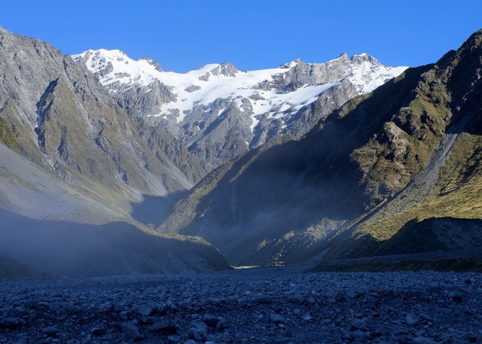
Above St Winifred's and as far as Veil Stream travel is faster on the TL , but is not a problem either side and above Veil you want to be on the TR. The valley now has closed in with the river flowing over moderate to large boulders. Stay as close as possible to the river but above the first major avalanche path, where the river has cut a gorge through bed rock, its is no problem to climb 80m to a tussock and speargrass hillside. Don't get too far from the river and shortly after the moraine terraces you finally come out on the gravel flats. An easy stroll will take you to the what remains of the terminal face of the Havelock Glacier.
The key to access is the river levels. How long it takes varies a lot with conditions most people will get to Mistakes Flats or Curtis in a moderate day and St Winifreds without trying too hard. From St Winifred's Hut it is another 3hrs to the glacial flats. Returning downstream is always faster. In winter the river flows can drop to nothing - the channels are often dry at Erewhon.
Four wheel drive vehicles, usually stating from the south bank, are often used to access the huts as far as Mistake Flats and can sometimes reach Eric's Biv. The scale of the place probably explains why so many visitors choose to rely on vehicles. But the level of use and the scale of the place also means there are kilometers to share and I have never found the vehicle use obtrusive.