Waingawa Track
- 2 hr – 3 hr one way
- Medium
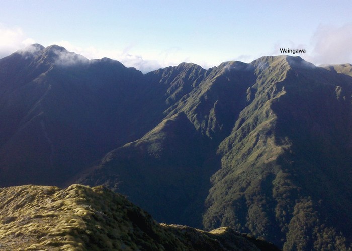
This is a non maintained route leading from Arete Forks up to the point of Waingawa 1420 Metres.The route meets the ridge top 300 metres west of Waingawa.
This was an access track developed by the NZ Forest Service for the culling operations in the 1960s. It allows tramping trips linking Cattle Ridge and also an alternative route to/from Arete Hut.
|
Walking time
|
2 hr – 3 hr |
|---|---|
|
Distance
|
2.0km |
|
Type
|
One way
|
|
Grade
|
Medium
Ascends bush spur of average steepness to the bushline, then steeper onto the top of the ridge, 300 metres west of Waingawa. Total climb approx. 660 metres. Grades explained
|
|
Bookings
|
No bookings — open access
No — open access
|
|
Starts
|
At junction of Arete Forks in the upper Waingawa |
|---|---|
|
Ends
|
At ridge top on Waingawa |
|
Maps
|
NZTopo50-BN34
|
|
Altitude
|
670m
–
1,423m
Altitude change 753m
|
The route has not been maintained for the last 20 years, although odd individuals have cut scrub and located permolat markers.
The route requires care when using it, due to poor marking. The beech forest is ok to walk through, as is following the old track up through the leatherwood. There are no markers on the tussock section.
The route begins at the Arete Forks, walk up the true left of Arete Stream for about 100 metres, then climb onto the river terrace. Pink Markers indicate the start. Follow the terrace downstream for 150 metres, then take leading spur up through the beech forest to the bushline. Occasional markers indicate the route.
At the edge of the leatherwood, an old cut track leads up to the tussock. This section has been cut enough to be followed ok. Shortly below the tussock, the route leads up an old steep stream bed/slip, climb out onto the east side at the top. A steel standard marks the entrance of the route at the top of the slip. Travel up to the ridge top is straight forward.
The route connects with the top of the main ridge to Bannister, 300 metres West of the Waingawa trig.
If coming downhill to Arete Forks take care to meet the slip on the east side only.
From Waingawa, the ridge top can be followed along to Cattle Ridge hut, or alternatively taking the well maintained track down to the Cow Saddle (and to Kiriwhakapapa roadend, beyond) A large cairn marks the start of the track down to Cow saddle.