

Trudge Col
This col is the gateway to adventures beyond the head of the Hawdon. Foolish folk will be lured from here down into Trudge Stream and a myriad of evil terrain features. There have even been rumours that individuals have even done it twice. The more pleasant alternatives depend on your destination: Otehake Hut or the head of the Poulter usually via Mt Hunt. Years ago we had an intrepid man in our tramping club, Les Jones, who led us to Otehake Hut via a low col a kilometer SW of Mt Hunt. He used to scope out routes by flying over them, a method better than using GoogleEarth but not so available to the likes of us. Anyhow, that one was straightforward, though a bit of a bowling alley for anything bigger than a party of 2.
Another place to go is Rough Peak which may live up to its name on the SE side of the summit. Positioning yourself between Smooth Peak and Mt Valiant will give you a chance to eyeball ugly steep stuff on its slopes. A friend who is the human equivalent of a thar has nipped up Rough Peak while we were embroiled with the debacle of a another tramper preprogrammed with a death wish that expressed itself by beelining for offroute unclimbable bluffs with resultant evacuation by rescuer’s rope or in this case, ditching his pack, only to nearly take us out with the resulting rockfall as we watched it tumble over the runout of bluffs looming above the head of the Hawdon. Ah, the joys of tramping with a club.
It had been 10 years since Frank and I had stood on Trudge Col. With perfect weather but high rivers and short days he came up with this idea after yet again reading in the Hawdon Shelter intentions book that hunters had ventured into Sudden Biv. A family had headed off up the Hawdon to Hawdon Hut ahead of us. It’s hard to know which is worse, little kiddies running around yelling and whining or hyped-up adolescents playing noisy cards till late. At least the littlelies go to bed early.
Off we went, choosing the flood track on the true left as the river crossing was up a bit by the shelter. We cut this overgrown route about 15 years ago and DoC started using it as a trapping trail with extensions not long after that. Where the trail dropped close to the river, we exited onto a pleasant flat and carried on upstream towards the junction with the East Hawdon. On the way we explored the start of another trapping track labeled Crazy Stream to bypass a further opportunity to experience the inevitable wet feet.
When we gained the quad bike trail where it crosses to the true left of the Hawdon we had the choice of following this or heading more directly through short open matagouri growing on the flats. A while back there used to be a foot trail through the prickly stuff but no one except maybe us goes this way anymore. We took the more time consuming but less thought consuming quake bike trail instead, studying footprints appearing in soft muddy patches. It looked as though there were 2 pairs of trail runners going in and someone had gone out.
We crossed the East Hawdon and further on the ford that DoC have signposted with their large orange triangles over the main Hawdon. Beyond this was the poignant clearing where the old hut once stood, marked by burnt wooden piles. This is where I first tramped to with my school tramping club, sleeping on ground sheets under flies. No poofter pads in those days but we were young of course. The teachers had stayed in the hut which was pretty much out of bounds to us. The next day we’d whipped up towards Walker Pass but hadn’t quite got there. Did I imagine then that I’d be back maybe a score times more? We were told it was THE MAIN DIVIDE! Not that I'd really understood what it meant. Surrounding the hut at the edge of the clearing under beech trees were soft cushions of vegetation that I’d camped on in later years on trips and courses fondly recalled.
But gosh, I’m not at the stage of only having fond memories so we carried on across the 2 braids of Discovery Stream which separated by a forested island. Frank smelled smoke, I think I smelled a dead stoat in the wooden trap box I was sitting on as I waited for him to catch up near the hut. Yes, the hut was occupied by the family with their dear little children of 4 and 7 who, being as fit as buckrats, were relishing their environs while Mum and Dad got a fire in the woodbox cranking into life. It seemed like a good idea tp carry on to the pass while the little ones blew off a bit of steam so we dropped packs and took off before the trotters started to cool down in the wet boots.
When you reach a certain age, it takes less time to go uphill than down and so it was with our taking 26 minutes to get to the top of the track where we could overlook the pretty meandering stream that leads to Walker Pass but it took 28 minutes to get back down the sections of greasy bedrock. The Twin Falls were in fine form after about 200 mm of rainfall during the week. Back at the hut, the kids were still frisking about. These country kids are fit, having walked into Welcome Flat on another trip recently.
I cooked dinner and we chatted with their amiable parents, enjoying the cosy warmth of the woodbox they continued to stoke. We had acquaintances and trips in common. I headed off to bed as we were planning not to waste daylight the next morning.
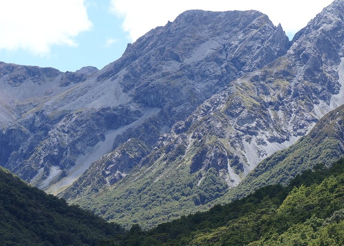
Surprisingly I was the first one up. We prepared our day packs and set off. I had a futile attempt to keep my feet dry at the first crossing of the main river that leads to the foot of the route to Trudge Col. The route to the col can be seen from the hut. It goes via stabilized scree. Towards the head of this scree, where it splits, a step leads out to the true left where one then continues gaining gradual height across scree below bluffs for a further 400 m traverse to Trudge Col. This step is the crux and its condition varies according to the presence of snow. Our mission was to check this out and report back.
The stream was nice in parts and a bit ugly in others, necessitating multiple crossings. At this time of morning it was gloomy and as we progressed up valley rocks bordering the river became treacherously glazed. After an hour of this, my tootsies became miserably cold so there was no lingering at the foot of the scree where I filled my water bottle.
The scree was good travel, initially on vegetated ground then thankfully there were slight runnels of larger stuff that were consolidated. At the top of the scree, it split and we sidled to the true right under a steep wall to study the route which was via a sloping step about 4 metres high that leads to the top of the next scree that takes you to the col. We were keen to see if it had changed due to weathering. I decided to tackle the corner that was quite mossy and had no hand holds. This led to a reasonable benched traverse. At a nice broadened section of it, I waited for Frank.
He went very carefully, scuffing out good foot placements. From where I was it looked steep and exposed but my way wouldn’t have been good for a descent. My runout looked better than his though as the bluff on my route wasn’t so high. I carried on to the next tricky bit which required a one metre wide traverse on a stiff unyielding slope so I used my walking pole and the flange on its tip to dig out and flatten platforms for my boots to edge into.
We nipped across this, Frank widening my edged out steps as he is more particular and then we topped a little scoop that led to the next scree. We pretty much diagonalled under the bluffs heading to the col. It was good going with no signs of anyone else having gone to the col this season. The col was in sunshine with a couple of boggy puddles. I went to the edge to have a look at the head of Trudge Stream. What I could see looked innocent enough with no indications of nasty waterfalls etc.
We retreated from the cool wind into a tussocked area for lunch in the lee of the small spur that leads to Rough Peak. I was glad to take my wet socks and boots off and insulate my feet from the wind by sticking them in my hat and covering this package with my black overtrousers to warm up to neutral. I draped the wrung out socks over rocks warmed by a direct line to the sun. I had hopes of hearing rock wrens in the pineapple scrub and scattered rocks but no luck there.
After an hour in the sun it was time to put socks and boots back on and head back to the valley which was mainly in shadow. We sidled and dropped down back to the little scoop then quickly ascended what we had carefully sidled and descended. Frank went down his way and I followed as my way would be greasy and have no handholds. I put my hat and hood on as a precaution in lieu of a helmet but his way was good as it was a benched gradual sidle with holds - though you had to make sure they were solid and not about to snap off in your hand.
Back on the scree we headed across to argillite leads where the scree is finer and used as many of these as we could to quickly drop back to the valley. The first time I ran down a scree following Les Jones, he’d stopped to put his gloves on and I do this too to spare my palms in case I slip over. Once in the valley we headed downstream and it seemed to go faster but in fact was not by much. Some parts were still in sun. I took care to avoid getting my feet wet with crossings as much as I could but the feet were quite warm by now so never cooled down, thank goodness.
The hut was empty but warmer than outside. We had a hot drink and snack to keep us going for the walk out to the car down the Hawdon Valley. After crossing the East Hawdon we opted to go through the matagouri to save 5 minutes and then crossed over to the true right to use the current quad bike track until we recrossed the river to get onto the flood track that we’d originally started up valley on. Frank reckoned the floodtrack was quicker than the valley floor though I have my doubts but was happy to use this to avoid a deeper crossing downstream of the wire fence opposite the Hawdon Shelter.
Surprisingly we were not the last ones to come out of the valley. A party of 3 had headed into the East Hawdon to traverse over Valiant and Smooth Peak and drop down to the main branch of the Hawdon. I’m guessing they may have been slowed down by an unfortunate route choice leading to fiddly travel in a stream coming down to the Hawdon. Frank left them a note on the windscreen to say they’d broken our tradition of being the last out.