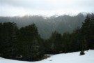
Nearby
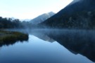
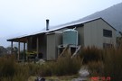
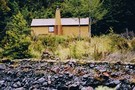
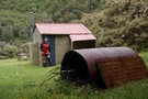
Lucretia Hut
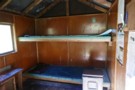
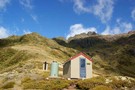
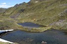
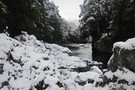
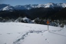
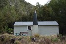
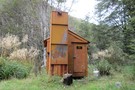
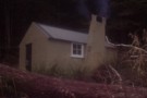
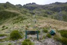
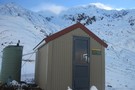
Lucretia biv
Photograph
•
Distance: less than 100m away
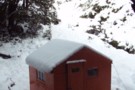
inside the biv - basic but welcome in bad weather - Feb 2018
More ▶︎
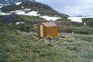
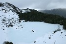
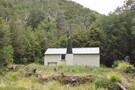
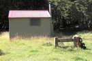
Lucretia biv
Photograph
•
Distance: less than 100m away
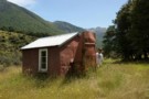
a good lunch stop on the route to the tops - Feb 2018
More ▶︎
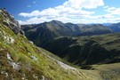
Lucretia Hut Route
Track
•
1 day. Easy/medium. Return by the same track.
•
Distance: 201m away
Lucretia biv via Nina Valley
More ▶︎
Lewis Pass National Reserve
Place
•
Reserve. 182.95km2.
•
Distance: 2.1km away
A small park occupying the forested valleys around Lewis Pass and bordering Lake Sumner and Victoria Forest Parks as well ...
More ▶︎
Lake Sumner Conservation Park
Place
•
Conservation Park. 1057.71km2.
•
Distance: 2.1km away
Lakes and forested hills in this sprawling park provide good tramping, and contrast with the rugged alpine environment of Arthur's ...
More ▶︎
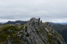
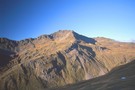
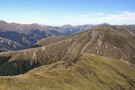
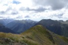
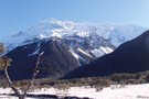
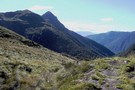
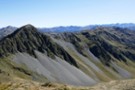
Mt Technical
Photograph
•
Distance: 2.2km away
south-west face, from the saddle SW of Lucretia - Feb 2018
More ▶︎
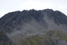
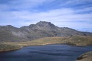
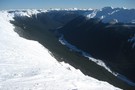
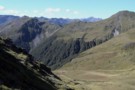
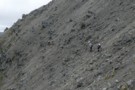
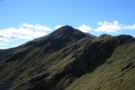
Lucretia
Photograph
•
Distance: 2.4km away
with cyclone Gita approaching (blowing from right to left and just able to stand against it), we were taking it ...
More ▶︎
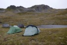
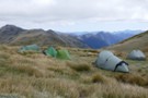
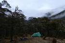
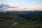
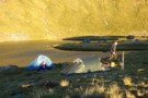
Apprentice tarns
Photograph
•
Distance: 2.6km away
our camp under the Apprentice - hoping for some shelter from the approaching cyclone Gita but it was a restless ...
More ▶︎
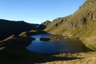
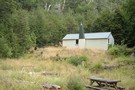
Tarns and Brass Monkey biv Dec 2011
Photograph
•
Distance: 2.8km away
This pic shows a couple of the tarns near the biv. The biv, an ex NZFS one, is in a ...
More ▶︎
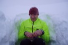
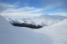
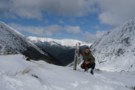
Snow hole lunch
Photograph
•
Distance: 2.9km away
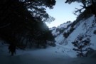
Taking refuge in a snow hole for lunch during a white out on the Lewis Tops, Lewis Pass.
More ▶︎
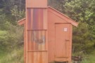
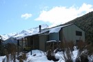
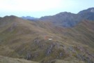
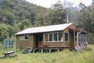
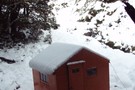
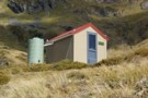
Brass Monkey Bivouac
Hut
•
Basic Hut/Bivvy (DOC). Capacity: 2.
•
Distance: 2.9km away
A basic 2 bunk bivvy on the Lewis Tops
More ▶︎
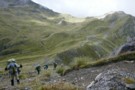
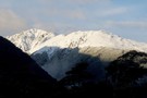
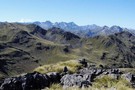
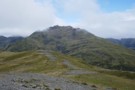
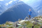
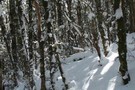
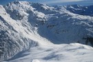
Lewis tops
Photograph
•
Distance: 3.6km away
climbing up to the tops with Mt Technical (left) and the Apprentice (right) behind - Feb 2018
More ▶︎
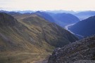
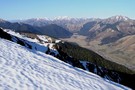
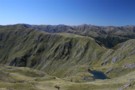
The Maruia Valley from the Lewis Tops
Photograph
•
Distance: 4.4km away
Springs Junction and Mount Haast in the distance
More ▶︎
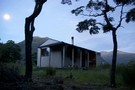
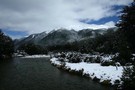
Nina Hut at Night
Photograph
•
Distance: 4.7km away
This hut is situated in a superb location, with wide views up all the valleys around it. A good move, ...
More ▶︎
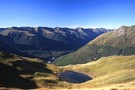
Lewis Tops from from Nina Hut
Photograph
•
Distance: 4.7km away
The view north from Nina Hut, March 2007
More ▶︎
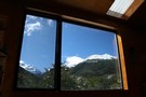
Nina Hut Views
Photograph
•
Distance: 4.7km away
Windows in the new Nina Hut are well set up for admiring the views.
More ▶︎
Deer Valley Campsite
Campsite
•
Informal campsite (DOC). 10 spaces.
•
Distance: 4.7km away
A minimal roadside camping area near Lewis Pass. Water is available from the nearby stream. Foleys Creek and Rolleston Pack ...
More ▶︎
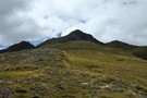
Trovatore Peak
Photograph
•
Distance: 4.7km away
The ridge to Trovatore Peak from Travers peak
More ▶︎
Foleys Creek Track - Travers Peak
Track
•
1 day. Medium. Return via same track.
•
Distance: 4.7km away
A poled route to the summit of Travers Peak near Lewis Pass
More ▶︎
Top of Travers Peak
Photograph
•
Distance: 4.7km away
View north from Travers Peak towards Gloriana Peak and the Fairie Queen
More ▶︎
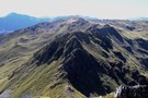
Libretto Range
Photograph
•
Distance: 4.7km away
View south along Libretto Range from Travers Peak
More ▶︎
Travers Peak - Trovatore - Henry Saddle
Track
•
2 days. Medium. Loop track.
•
Distance: 4.7km away
An interesting circuit exploring the alpine tops around Lewis Pass.
More ▶︎
Nina River
Track
•
2 days. Easy. Return by the same track.
•
Distance: 4.9km away
Easy tramping up a pretty river valley near Lewis Pass.
More ▶︎
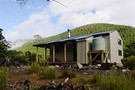
Nina Hut
Hut
•
Standard Hut (DOC). Capacity: 10.
•
Distance: 4.9km away
Replacing the old hut down by the river, this hut is located in an elevated clearing with good mountain views. ...
More ▶︎
Picton to Aspiring
GPX file
•
Distance: 4.9km away
An aborted alpine traverse. Picton to West Cape, but aborted at Aspiring due to real world emergencies back home. Posted ...
More ▶︎
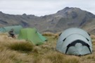
Lewis Tops camping 2
Photograph
•
Distance: 5.0km away
2 small tarns and a shallow gully to provide good shelter make for a good campsite, after reaching the Lewis ...
More ▶︎
Lewis Tops camping 3
Photograph
•
Distance: 5.0km away
Panorama with Mt Technical & the Apprentice as backdrop to the Lewis Tops - just past pt 1561, 2 small ...
More ▶︎
Lewis Tops camping
Photograph
•
Distance: 5.0km away
2 small tarns and a shallow gully to provide good shelter make for a good campsite, after reaching the Lewis ...
More ▶︎
Lewis tops
Photograph
•
Distance: 5.1km away
Panorama (click to see the whole pic) from near SH1535, looking along the tops to the descent to Lewis Pass.
The ...
More ▶︎
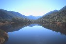
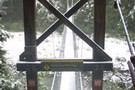
Nina River First Swing Bridge ~ Snowy
Photograph
•
Distance: 5.3km away
The first swing bridge, in winter, gorgeous
More ▶︎
Lewis Tops
Track
•
1 – 2 days. Medium. Return by the same track.
•
Distance: 5.4km away
A short climb onto the tops at Lewis Pass, providing panoramic views of the area. With camping on the valley ...
More ▶︎
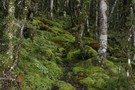
Rolleston Pack Track
Track
•
Easy. One way.
•
Distance: 5.6km away
An old pack track near Lewis Pass. This is a pleasant forest walk, and an alternative to walking along the ...
More ▶︎
Devils Rampart
Photograph
•
Distance: 5.7km away
from the Sylvia tops, the Devils Rampart is slowly revealed as the mists begin to lift - Feb 2018
More ▶︎
Camp above Rough Creek
Photograph
•
Distance: 6.0km away
Superb camp site by a small tarn only 100m from the Rough Creek saddle on the way to Lake Christabel
More ▶︎
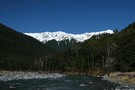
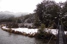
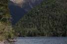
Lewis River
Photograph
•
Distance: 6.1km away
Lewis River near Palmer Lodge at the start of the Nina Valley Track, October 2009.
More ▶︎

St James Walkway
Track
•
5 days. Easy/medium. One way.
•
Distance: 6.7km away
A long and easy walk on St James Station near Lewis Pass. Beech forest, mountain scenery, farmland, wild horses, mud.
More ▶︎

Profile : St Arnaud - Lewis Pass
Photograph
•
Distance: 6.7km away
A useful profile of the 100km tramp - with a couple of bad weather alternatives :
1. low route past Speargrass ...
More ▶︎

St Arnaud - Lewis Pass
Article
•
Distance: 6.7km away
A 9-day 100km tramp via the Thompson, D'Urville and 3 Tarns Passes
Feb 2013
More ▶︎
St Arnaud to Lewis Pass
Track
•
5 – 9 days. Medium/hard. One way.
•
Distance: 6.7km away
A 5-9 day north-south route from St Arnaud to the Lewis Pass, via Travers Pass, Waiau Pass, Thompson Pass and ...
More ▶︎
Lewis Pass tops
Photograph
•
Distance: 6.8km away
Looking toward Cannibal Gorge and the St James.
More ▶︎
Lewis Pass Tops
Track
•
Medium. Return by the same track.
•
Distance: 6.8km away
A superb track which provides quick access to the open tops of the Lewis Pass.
Allow around 1.5 hours to reach ...
More ▶︎
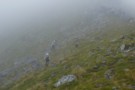
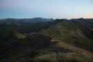
Sylvia tops
Photograph
•
Distance: 6.8km away
on the Sylvia tops and in the clag as we contoured around the north side of SH1662 - Feb 2018
More ▶︎
Pell Stream
Track
•
2 – 3 days. Medium. Loop track with a road section.
•
Distance: 6.8km away
This highly recommended valley not far from the highway west of the Lewis pass, is accessible to most people with ...
More ▶︎
Alpine Tarn
Photograph
•
Distance: 6.8km away
early morning at Lewis Pass (start of the St James Walkway)
Feb 2013
More ▶︎
Mueller Tarn Track
Track
•
Easy/medium. Return via same track.
•
Distance: 6.9km away
A steep but easy climb to a pretty alpine tarn near Lewis Pass
More ▶︎

Lake Thompson
Photograph
•
Distance: 6.9km away
A view of the beautiful Lake Thompson, a short distance from Thompson Pass
More ▶︎
Ada Cullers Hut
Photograph
•
Distance: 6.9km away
Tidy old shack provides shelter and shade from the elements. No mattresses or water supply.
More ▶︎
Boyle Flats Hut
Photograph
•
Distance: 6.9km away
Perched high on a river terrace, accessed from a swingbridge 'on the Boyle'.
More ▶︎
St James Walkway June 2009
Photograph
•
Distance: 6.9km away
Gloriana and the Faerie Queene, on a brilliant winter's day.
More ▶︎
Lewis Pass Tops
Photograph
•
Distance: 6.9km away
View of the Maruia River and Cannibal Gorge from Lewis Pass Tops
More ▶︎

Route Guide: St Arnaud to Lewis Pass
Article
•
Distance: 6.9km away
A 5-7 day north-south route from St Arnaud to the Lewis Pass, via Travers Pass, Waiau Pass, Thompson Pass and ...
More ▶︎
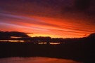
Lonely camper
Photograph
•
Distance: 6.9km away
The hut became rather full with a boy's school excursion. A (clever) tutor decided the nightlife outside may be quieter.
More ▶︎
Exploring Lewis Pass
Article
•
Distance: 6.9km away
There is a good range of tracks and routes around Lewis Pass to suit all abilities. Here is a selection ...
More ▶︎
Cannibal Gorge, Ada Pass
Track
•
2 days. Easy. Return via same track.
•
Distance: 6.9km away
An easy overnighter through the pretty bush of Cannibal Gorge and on to the alpine views of Ada Pass.
More ▶︎
Tarn Nature Walk
Track
•
Easy. loop track.
•
Distance: 6.9km away
A nature trail exploring the wetland plants on Lewis Pass
More ▶︎
Lewis Tops
Article
•
Distance: 6.9km away
A light hearted trip report up onto the Lewis Tops, Lewis Pass in winter.
More ▶︎
St James Conservation Area
Place
•
Place. 781.96km2.
•
Distance: 6.9km away
A large new recreational area featuring tussock grasslands, and including the headwaters of the Waiau and Clarence Rivers.
More ▶︎
Lewis Pass Lookout
Track
•
Easy. loop track.
•
Distance: 7.1km away
A loop track at Lewis Pass leading to a good view of the Cannibal Gorge.
More ▶︎
Mueller Tarn
Photograph
•
Distance: 7.1km away
A snowy tarn just above the treeline near Maruia Springs.
More ▶︎
Lewis Tops from Mueller Tarn
Photograph
•
Distance: 7.1km away
This is the view south across the valley.
More ▶︎
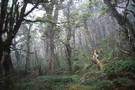
Near Devilskin Saddle
Photograph
•
Distance: 7.2km away
Fresh snow in the beech forest northeast of Devilskin Saddle. October 2009.
More ▶︎
Devils Den Bivouac
Photograph
•
Distance: 7.5km away
Devils Den Bivouac, below Devilskin Saddle between the Nina and Doubtful valleys. March 2007 - 3 feet of snow on ...
More ▶︎
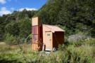
Devils Den Bivouac
Hut
•
Basic Hut/Bivvy (DOC). Capacity: 2.
•
Distance: 7.5km away
Devils Den / Devilskin bivouac (2 beds) is a brand new bivouac ABOVE Devilskin Pass. Built in 2008, this new ...
More ▶︎
Doubtful Hut
Photograph
•
Distance: 7.5km away
Old timer shack with 3-4 bunks near the Doubtful River, Northern Canterbury.
More ▶︎
Snow, old Devil's Den Hut site
Photograph
•
Distance: 7.5km away
The old hut site was at the treeline east of Devilskin Saddle. After an avalanche, a new hut was built ...
More ▶︎
Rough Creek track
Photograph
•
Distance: 7.7km away
Rough Creek track on one of the steeper parts
More ▶︎
Rough Creek Tops
Photograph
•
Distance: 7.7km away
2010 in the hanging basin at the head of Rough Creek
More ▶︎
Rough Creek tops, view east
Photograph
•
Distance: 7.7km away
View down Rough Creek from slightly north of the track
More ▶︎
Rough Creek Track
Track
•
Medium. Return via same track.
•
Distance: 7.7km away
The track leads up to Rough Creek Saddle from where there is a great view on Lake Christabel and the ...
More ▶︎
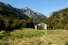
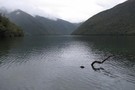
Lake Christabel hut August 2010
Photograph
•
Distance: 7.8km away
A tidy hut situated on the TL bank of the Blue Grey River about 20 minutes above Lake Christabel near ...
More ▶︎
Head of Lake Christabel August 2010
Photograph
•
Distance: 7.8km away
Lake Christabel is a large boomerang shaped lake approx 3km long. The lake was caused centuries ago by a slip ...
More ▶︎
Lake Christabel Hut
Hut
•
Standard Hut (DOC). Capacity: 8.
•
Distance: 7.8km away
A tidy hut situated on the TL bank of the Blue Grey River about 20 minutes above Lake Christabel near ...
More ▶︎
Robinson Saddle
Track
•
3 days. Easy/medium. One way.
•
Distance: 7.8km away
Forest and tops walk in Victoria Forest Park, visiting Lake Christabel.
More ▶︎
Sylvia Flats
Campsite
•
Private Hut (Not applicable).
•
Distance: 7.8km away
A marked rest area on SH7 near Lewis Pass, with ample space to stop and camp as well as hot ...
More ▶︎
Sylvia Flats
Track
•
Easy. Return via same track.
•
Distance: 7.8km away
Roadside hot pools near Lewis Pass
More ▶︎
Upper Nina Biv
Hut
•
Basic Hut/Bivvy (DOC). Capacity: 2.
•
Distance: 7.9km away
Small hut on the Nina River. Two canvas bunks.
More ▶︎
Scree traverse
Photograph
•
Distance: 7.9km away
a long traverse on virgin scree high above Devilskin saddle - Feb 2018
More ▶︎
Devilskin Saddle
Photograph
•
Distance: 8.0km away
Devilskin Saddle between the Nina and Doubtful Valleys off the Lewis Pass. March 2007.
More ▶︎
Climbing above Devilskin Saddle
Photograph
•
Distance: 8.0km away
day triping up from the Devilskin Saddle Hut June 2010. (lewis pass)
See hut and toilet on the saddle below.
Also see ...
More ▶︎
Freyberg Range, Pell Stream
Article
•
Distance: 8.0km away
A 3 day trip, climbing up onto the range to go over Mt Mueller and camp. Followed by a descent ...
More ▶︎
Devilskin Saddle
Photograph
•
Distance: 8.1km away
from the saddle, the new biv is 50m west towards the Devils Rampart. (photo taken Feb 2018)
More ▶︎
Devils Den Bivouac above Devilskin Pass
Photograph
•
Distance: 8.1km away
Built in 2008, this is, perhaps, the bestest and newest little hut in NZ.
More ▶︎
Devils Den Bivouac
Photograph
•
Distance: 8.1km away
Built in 2007 to replace the old version which was below Devilskin Saddle by the bushline. This new, sparkly version ...
More ▶︎
New Devils Den Bivvy Location
GPX file
•
Distance: 8.1km away
A GPX file of the new bivvy located on Devilskin Saddle.
The old Devils Den Bivvy has been removed.
More ▶︎
Lewis Tops from Travers Peak
Photograph
•
Distance: 8.1km away
Lewis Tops and Mount Technical are in the distance. The spur southwest of Trovatore is closer, and the northern slopes ...
More ▶︎
Mephistopheles
Photograph
•
Distance: 8.4km away
One of the named peaks along the Libretto Range, which runs from Lewis Pass to Boyle Village.
The ridge to Faust ...
More ▶︎
Travers Peak from Trovatore
Photograph
•
Distance: 8.5km away
The ridgeline between Travers and Trovatore is rough.
More ▶︎
Tarn, Trovatore
Photograph
•
Distance: 8.5km away
Comfortable camping just east of Trovatore.
More ▶︎
Boyle Village - Mt Faust - Boyle Hut
Track
•
1 day. Medium. One way.
•
Distance: 9.3km away
A great trip over the top of Mt Faust and down a spur to Boyle Hut on the St James ...
More ▶︎
Magdalen Valley
Photograph
•
Distance: 9.3km away
View east over Magdalen Valley to Waiau from Faust
More ▶︎
Rokeby Hut
Hut
•
Basic Hut/Bivvy (DOC). Capacity: 3.
•
Distance: 9.5km away
Hidden on a high bench above the Boyle River. Three canvas bunks, 2 cute seats and a woodstove make for ...
More ▶︎
Rokeby Hut
Photograph
•
Distance: 9.5km away
Rokeby Hut is an old cullers hut about 1 hour upstream from the Boyle Flats Hut. Three canvas bunks and ...
More ▶︎
Boyle Flats Hut
Hut
•
Serviced Hut (DOC). Capacity: 20.
•
Distance: 9.9km away
Perched high above the river on a grassy bench, Boyle Flats Hut is accessed via a swingbridge over the Boyle.
More ▶︎
Zampa Kampas
Photograph
•
Distance: 9.9km away
a campsite beside Zampa Lake.300m under & east of Zampa herself.
More ▶︎
Zampa Lake
Photograph
•
Distance: 9.9km away
2 hectare lake under Zampa Peak.Idyllic campsite at 1450m
More ▶︎
Head of the Henry River
Photograph
•
Distance: 9.9km away
Between Trovatore and Henry Saddle.
More ▶︎