Nearby
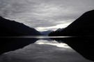
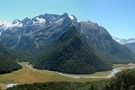
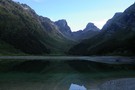
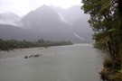
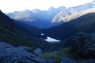
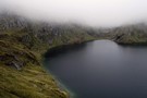
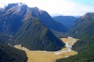
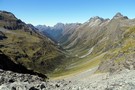
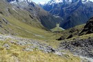
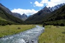
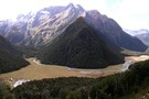
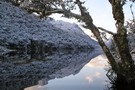
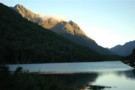
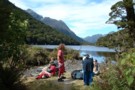
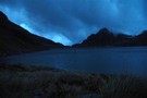
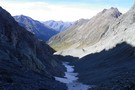
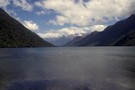
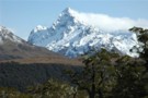
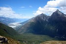
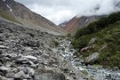
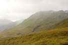
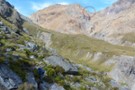
View from Lake Alabaster
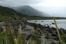
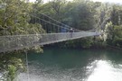
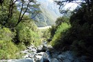
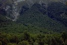
Hollyford Track
Track
•
4 days. Medium. One way.
•
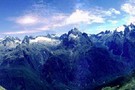
Distance: less than 100m away
The Hollyford Track is a classic lowland Fiordland route from the Hollyford Road out to the coast at Martins Bay.
More ▶︎
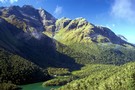
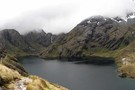
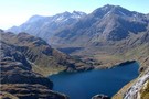
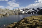
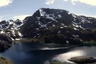
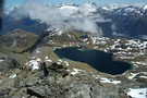
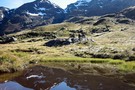
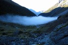
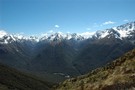
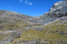
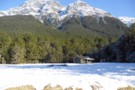
Lake Mackenzie and the Ailsa Range
Photograph
•
Distance: 2.1km away
Mackenzie Hut is near the lake edge, with the guided walks hut further back.
More ▶︎
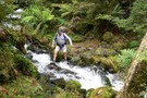
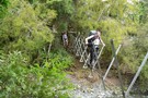
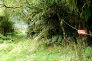
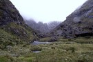
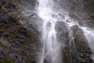
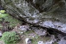
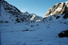
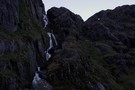
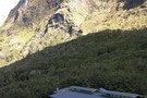
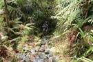
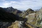
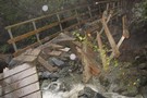
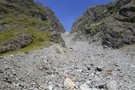
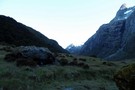
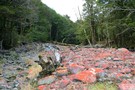
THE START OF THE DEMON TRAIL
Photograph
•
Distance: 2.6km away
Over this bridge the trail starts to live up to its name
More ▶︎

Haast to The Divide
GPX file
•
Distance: 2.7km away
Andrew Barker's traverse 2009. From Pleasant Flat in the Haast to The Divide via Mt Aspiring National Park.
More ▶︎
Big Bay - Pyke - Hollyford Road-end Route
GPX file
•
Distance: 2.8km away
Big Bay - Pyke - Hollyford Road-end Route as tramped by us in May 2012 and recorded with Garmin GPS60csx
More ▶︎
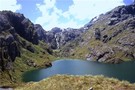
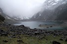
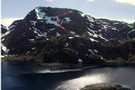
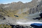
Lake MacKenzie
Photograph
•
Distance: 2.8km away
The lake just below the DoC hut, looking towards Emily Pass.
More ▶︎
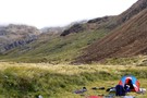
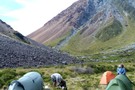
Lake Mackenzie Campsite
Campsite
•
Great Walks Campsite (DOC). 9 spaces.
•
Distance: 2.8km away
Small campsite on the Routeburn Track located near the hut.
More ▶︎
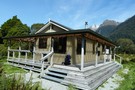
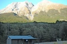
Lake Mackenzie Hut
Hut
•
Great Walks Hut (DOC). Capacity: 50.Bookings required.
•
Distance: 2.8km away
A Great Walks Hut on the Routeburn Track. During the summer season, bookings are required, with a maximum two-night stay. ...
More ▶︎
Not The Routeburn
GPX file
•
Distance: 2.8km away
A six-passes, seven catchments trip through the Humboldt Mountains from Glenorchy to The Divide.
Note that for access from Double Barrel ...
More ▶︎

Great Walks Information
Article
•
Distance: 2.8km away
The DOC Great Walks are a set of premium tramping tracks throughout New Zealand.
More ▶︎
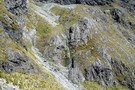
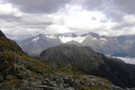
Parorama from Harris Saddle
Photograph
•
Distance: 2.8km away
several photographs put together to create a panoramic view
More ▶︎
Routeburn Track
Track
•
2 – 4 days. Easy/medium. One way.
•
Distance: 2.8km away
An internationally renowned and popular alpine crossing between Fiordland and Lake Wakatipu.
More ▶︎
Emily Peak Reflections
Photograph
•
Distance: 2.9km away
Serenity can be found early morning at places like Lake Mackenzie.
More ▶︎
Pyke - Big Bay Route
Track
•
3 – 4 days. Hard. One way.
•
Distance: 2.9km away
A more challenging extension to the Hollyford Track following old roads, rivers, lake edges, and beaches.
More ▶︎
Misty Morning Reflections at Lake MacKenzie
Photograph
•
Distance: 2.9km away
Taken from near the campisite at the top of lake on a cool crisp March morning, fog swirls over reflections ...
More ▶︎
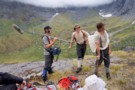
The Orchard
Photograph
•
Distance: 3.0km away
Open space edged by ribbonwood near Lake Mackenzie.
More ▶︎
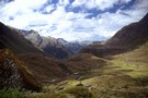
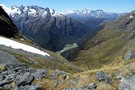
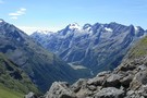
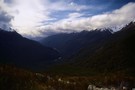
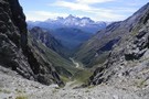
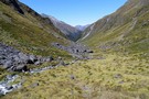
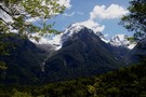
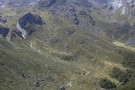
The Darran Mountains
Photograph
•
Distance: 3.0km away
Taken from the Routeburn North of The Orchard, almost the whole length of the Hollyford valley is visible with Lake ...
More ▶︎
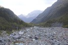
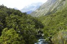
McKerrow Island ford
Photograph
•
Distance: 3.3km away
Crossing site to reach McKerrow Island. Not very passible with the Hollyford river in flood!
More ▶︎
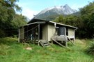
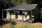
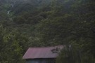
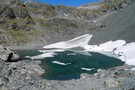
Lake Alabaster Hut
Hut
•
Serviced Hut (DOC). Capacity: 26.
•
Distance: 3.4km away
Second hut on the Hollyford Track.
More ▶︎
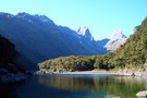
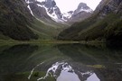
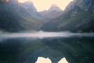
Lake Alabaster from the South
Photograph
•
Distance: 3.4km away
Taken from the beach about 5 minutes from the Lake Alabaster hut.
More ▶︎
McKerrow Island Hut
Hut
•
Standard Hut (DOC). Capacity: 12.
•
Distance: 4.2km away
Alternative hut located at the head of Lake McKerrow on the Hollyford Track. The hut is located on an island, ...
More ▶︎
McKerrow Island Hut
Photograph
•
Distance: 4.2km away
basic hut with "emergency shower" (dip in the lake)
More ▶︎
Harris Saddle Shelter
Hut
•
Shelter (DOC).
•
Distance: 4.3km away
Enclosed day shelter perched on Harris Saddle, on the Routeburn Track. Overnight use prohibited. A side trip from here leads ...
More ▶︎
Routeburn Tops
Photograph
•
Distance: 4.4km away
The Route Burn meanders through this basin beneach Harris Saddle.
More ▶︎
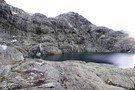
Lake Mackenzie
Photograph
•
Distance: 4.4km away
Lake MacKenzie from the basin below Emily Col. Good campspots and a so-so rock biv marked by a cairn.
More ▶︎
Lake Harris
Photograph
•
Distance: 4.4km away
January 2009, Although it doesn't look like, we had awesome weather :)
More ▶︎
Lake Harris, Routeburn Track.
Photograph
•
Distance: 4.4km away
From Lake Harris and Harris Saddle, the Left Branch of the Route Burn leads up to the Lake Wilson (at ...
More ▶︎
The Serpentine Range and the Three Passes
Article
•
Distance: 4.4km away
A six day trip around the Three Passes, including a traverse of the Serpentine Range instead of the North Route ...
More ▶︎

Mount Aspiring National Park
Place
•
National Park. 3555.18km2.
•
Distance: 4.4km away
The third-largest national park, although most of its space is under-utilised. The Routeburn is the second busiest trail in New ...
More ▶︎
Lake Harris Western Shore
Photograph
•
Distance: 4.5km away
The western end of Lake Harris looking towards the entrance to the Valley of the Trolls. The route to the ...
More ▶︎
Lake Wilson and the Valley of the Trolls
Track
•
2 – 3 days. Medium. Return by the same track.
•
Distance: 4.5km away
An overnight or multiday scenic diversion from the Routeburn Great Walk. The Valley of the Trolls is easily accessed from ...
More ▶︎
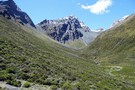
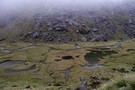
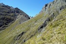
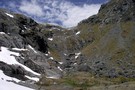
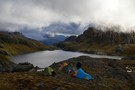
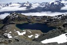
Emily Pass 1200m Basin
Photograph
•
Distance: 4.5km away
There's great camping to be had in the large grassy basin at just over 1200m on the south side of ...
More ▶︎
The track is booked out? Try TrekWatch.net
Article
•
Distance: 4.5km away
SMS texts directly to your cellphone when a place becomes available. Free of charge!
More ▶︎
Routeburn Flats
Photograph
•
Distance: 4.5km away
The view over Routeburn Flats is the quintessential photo of the Routeburn Track
More ▶︎
Harris Saddle, Routeburn
Photograph
•
Distance: 4.5km away
Harris Saddle, Routeburn, Sept 2006
More ▶︎
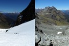
Emily Pass 1400m Basin
Photograph
•
Distance: 4.9km away
What a difference a month makes.
Left photo mid December 2014. Right photo mid January 2015.
More ▶︎
Routeburn Flats
Photograph
•
Distance: 4.9km away
An interesting hours excursion from Routeburn Falls hut takes you up the hill to the South of the hut giving ...
More ▶︎
The Valley of the Trolls
Photograph
•
Distance: 5.0km away
Looking into the rain swept valley. The route in climbs over the rocks on the True Right of the Route ...
More ▶︎
Head of the Fraser Valley
Photograph
•
Distance: 5.0km away
This photo is taken from the site marked on the topo map where a rock bivy is supposed to exist. ...
More ▶︎
Lake Harris from Conical Hill
Photograph
•
Distance: 5.0km away
If you are walking the Routeburn Track, don't miss the opportunity to climb Conical Hill from the Harris Saddle shelter. ...
More ▶︎
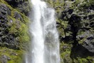
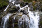
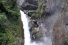
Earland Falls
Photograph
•
Distance: 5.1km away
A 174m watterfall that the Routeburn track passes right underneath.
More ▶︎
Emily Pass South View
Photograph
•
Distance: 5.3km away
What a difference a month makes.
Left photo mid December 2014. Right photo mid January 2015.
More ▶︎
Emily Pass View
Photograph
•
Distance: 5.3km away
The view north from Emily Pass.
December 2014
More ▶︎
Valley of the Trolls from rock bivy
Photograph
•
Distance: 5.3km away
Despite the abundance of boulders in the Valley of the Trolls, there is vertually no natural shelter here. One place ...
More ▶︎
Valley of the Trolls Rock bivvy
Rock bivouac
•
Distance: 5.4km away
Rock bivvy formed by an overhanging cliff. Probably enough room for about a dozen people but the northern end is ...
More ▶︎
Valley of the Trolls Rock bivvy
Photograph
•
Distance: 5.4km away
Rock bivvy underneath an overhanging cliff about half way up the Valley of the Trolls and about 40m above the ...
More ▶︎
Route up to Emily Pass
Photograph
•
Distance: 5.5km away
This is looking west at the northern route up to Emily Pass, and is the opposite direction from this photo: ...
More ▶︎
Fraser Col to Emily Pass Sidle.
Photograph
•
Distance: 5.5km away
This photo is looking east at Fraser Col from the true right top of the gut of the initial climb ...
More ▶︎
Old Routeburn Falls Hut 1989
Photograph
•
Distance: 5.6km away
The old Routeburn Falls Hut I stayed at in 2 November 1989 and 23 January 1990. Picture from November 1989. ...
More ▶︎
Fraser Valley from Fraser Col
Photograph
•
Distance: 5.7km away
The view down the Fraser from just below the Col.
January 2015.
More ▶︎
Valley of the Trolls, January 16, 2012
Photograph
•
Distance: 5.7km away
Result of 24 hours snow fall on Jan 14 & 15. What about summer! Looking back towards the Routeburn Track.
More ▶︎
Fraser Creek
Track
•
1 – 2 days. Easy/medium. One way.
•
Distance: 5.7km away
One of several valleys that cut into the southern Humboldt Mountains. It passes through many kilometres of beech forest, river ...
More ▶︎
Emily Basin from Fraser Col
Photograph
•
Distance: 5.7km away
Looking north from Fraser Col across Emily Basin.
January 2015.
More ▶︎
The Route up to Lake Wilson
Photograph
•
Distance: 5.8km away
It begins here at the foot of the waterfall at the head of the Valley of the Trolls and climbs ...
More ▶︎
Emily Basin
Photograph
•
Distance: 5.8km away
High above the Routeburn at the top of Emily Creek, about 1.5 hours climb from Emily Creek bridge. Fraser Col ...
More ▶︎
Lake Marian
Photograph
•
Distance: 5.9km away
Taken in October 2010 the lake appeared tiny in comparison to other photos and videos Ive seen of it online, ...
More ▶︎
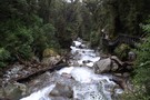
Fraser Creek Waterfall
Photograph
•
Distance: 5.9km away
Unnamed waterfall crashing out of a hanging valley about half way up the Fraser. Its well worth the 15-20 minute ...
More ▶︎
Fraser Creek flats
Photograph
•
Distance: 5.9km away
Fraser Creek passes through several grass flats which get more and more pleasant the closer to the head of the ...
More ▶︎
Routeburn Falls hut
Photograph
•
Distance: 5.9km away
Routeburn Falls hut - great views (April 2009)
More ▶︎
Marian Creek
Photograph
•
Distance: 6.0km away
Taken from the viewing gantry, an easy 10 minute walk from the carpark, Marian creek tumbles down the hillside on ...
More ▶︎
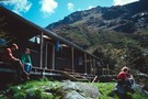
Routeburn Falls Hut
Hut
•
Great Walks Hut (DOC). Capacity: 48.Bookings required.
•
Distance: 6.0km away
A modern hut on the Routeburn track. It is at bushline on the edge of the cirque that leads up ...
More ▶︎
Demon Trail Hut
Hut
•
Serviced Hut (DOC). Capacity: 12.
•
Distance: 6.0km away
Demon Trail Hut (serviced, 12 bunks, stove, firewood) marks the southern end of the infamous Demon Trail. Between the Hollyford ...
More ▶︎
Lake Marian
Track
•
Easy/medium. Return via same track.
•
Distance: 6.0km away
Short walk from the Hollyford Road up to a hanging valley and lake in the Darran Mountains.
More ▶︎
Routeburn Falls
Photograph
•
Distance: 6.0km away
Located near the Falls hut these impressive falls are passed on the way to Harris Saddle.
More ▶︎
Routeburn
Photograph
•
Distance: 6.2km away
Taken from a slip below the Routeburn Falls hut (April 2009)
More ▶︎
Harris Saddle and Valley of the Trolls from Lake Wilson outlet
Photograph
•
Distance: 6.2km away
At the top of the climb to Lake Wilson this great view is to be had when looking south. Ocean ...
More ▶︎
Lake Wilson from the outlet
Photograph
•
Distance: 6.2km away
The first view of Lake Wilson you are greeted with upon reaching the lake. Theres good camping here. 5th Jan ...
More ▶︎
Boyd Creek to The Divide via Kiwi Burn and the Mavora Walkway
Article
•
Distance: 6.2km away
A New Year's trip through the Snowdon Forest and on to The Divide. Heavily affected by weather, I had to ...
More ▶︎
Key Summit
Track
•
Easy. Return via same track.
•
Distance: 6.3km away
Short, easy walk at the start of the Routeburn Track to a low summit. Panoramic views of the Greenstone, Hollyford, ...
More ▶︎
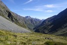
Hollyford Valley
Photograph
•
Distance: 6.3km away
The Hollyford Valley floor sits just above sea level, while the Routeburn Track creeps along the Serpentine Range at around ...
More ▶︎
Howden Hut
Hut
•
Great Walks Hut (DOC). Capacity: 28.
•
Distance: 6.3km away
Hut on the Routeburn Track, destroyed by a landslide in February 2020.
More ▶︎
Emily Creek
Photograph
•
Distance: 6.4km away
In Emily Creek looking down towards the bridge. Once you you get past the initial large boulders it's a typical ...
More ▶︎
Lake Wilson Panorama
Photograph
•
Distance: 6.4km away
Lake Wilson with Mt Erebus and Mt Xenicus above. 5th Jan 2013
More ▶︎
Routes up Mt Erebus
Photograph
•
Distance: 6.4km away
There are at least 3 possible routes to climb Erebus from Lake Wilson. The red and blue routes go up ...
More ▶︎
The Divide Shelter
Hut
•
Shelter (DOC).
•
Distance: 6.5km away
Open shelter at the Milford end of the Routeburn Track. Overnight use prohibited.
More ▶︎
Damaged bridge between Routeburn Falls and Routeburn Flats Huts
Photograph
•
Distance: 6.6km away
Photograph courtesy of DOC, I think. Around 30 April. Repairs not expected for about 3 months. This creek is easily ...
More ▶︎
Lake Howden
Photograph
•
Distance: 6.7km away
Summer at Lake Howden is a magic time. The wind is warm, days are hot and sunny, and the fellow ...
More ▶︎
Southern (waterfall) route up Erebus
Photograph
•
Distance: 6.7km away
A photgraph from near the bottom of the climb up the southern route to Erebus (I had just climbed down ...
More ▶︎
Routeburn Flats
Campsite
•
Great Walks Campsite (DOC). 15 spaces.
•
Distance: 6.8km away
Grassy camping next to Routeburn Flats Hut.
More ▶︎
Routeburn Flats Hut
Hut
•
Great Walks Hut (DOC). Capacity: 20.Bookings required.
•
Distance: 7.0km away
A large hut on the Routeburn Track, often bypassed for the Routeburn Falls Hut which is 1 hour further along ...
More ▶︎
Rockburn - Lake Nerine - North Routeburn
Track
•
3 – 5 days. Medium. Loop track.
•
Distance: 7.0km away
A slightly shorter option to the 5 passes trip but of similar if not more difficulty. Can be done in ...
More ▶︎
Stormy skies over Lake Wilson
Photograph
•
Distance: 7.2km away
It blew but didn't come to much
More ▶︎
Double Barrel from pass with the Fraser
Photograph
•
Distance: 7.2km away
Double Barrel Creek from the pass into the Fraser. Mt Earnslaw looking bare & bleak without snow cover in the ...
More ▶︎
North Routeburn Rock bivvy
Photograph
•
Distance: 7.3km away
I've guessed the location from a description but don't take my word for it.
More ▶︎
North Route Burn Rock bivvy
Rock bivouac
•
Distance: 7.3km away
2 person biv rumoured to be 500m from the Routeburn Track in the North Branch of the Route Burn on ...
More ▶︎
Camping at Lake Wilson
Photograph
•
Distance: 7.4km away
When the snows gone, the head of the lake is a spectacular place to pitch your tent. January 2017
More ▶︎
Double-Barrel - Fraser Pass
Photograph
•
Distance: 7.4km away
A steep, loose but otherwise straight forward pass out of the Double Barrel into the Fraser
More ▶︎
Lake Wilson from near Mt Erebus
Photograph
•
Distance: 7.4km away
I didnt summit Erebus due to exhaustion and the snow conditions but from 1860m the view is almost as fine! ...
More ▶︎
Greenstone Saddle Camping Area
Campsite
•
Informal campsite (DOC).
•
Distance: 7.5km away
Large informal campsite at Greenstone Saddle, near the top of the Greenstone Track.
More ▶︎
Mt Tutoko and the Darrans from Lake Wilson
Photograph
•
Distance: 7.5km away
While on a circuit of Lake Wilson, Peak 1680 is a hard scramble on the northwestern corner of the lake. ...
More ▶︎
Morning at the Greenstone Saddle Camping Area.
Photograph
•
Distance: 7.6km away
Morning at the Greenstone Saddle Camping Area. McKellar Saddle, cloaked in cloud and dusted with snow, is left of centre.
More ▶︎
Five Passes via Lake Nerine and North Col
Article
•
Distance: 7.6km away
A classic tramp north of the Routeburn. Rather than exit via the Rockburn, we extended the trip through Lake Nerine ...
More ▶︎
Death Valley glacier (rems.)
Photograph
•
Distance: 8.0km away
Death of a glacier.
Death Valley, Humboldt Mountains
More ▶︎
Double Barrel Creek
Photograph
•
Distance: 8.1km away
Double Barrel Creek from the pass into Death Valley.
Catchment is blocked by twin falls at its lower end, but ...
More ▶︎
Falls Creek
Track
•
1 – 2 days. Medium. Return by the same track.
•
Distance: 8.1km away
Day or overnight trip to a choice of two rock bivvies off the Milford Road.
More ▶︎
Lake Alabaster from the North
Photograph
•
Distance: 8.1km away
Taken from the Northern head of the lake looking South. 3 hours of wading in the lake awaits to reach ...
More ▶︎
Greenstone Track
Track
•
2 – 3 days. Easy. One way.
•
Distance: 8.3km away
A famous, easy track along red tussock river flats.
More ▶︎
Phil's Biv
Rock bivouac
•
Distance: 8.3km away
Rock biv high above the head of lake Adelaide, beneath Marian Peak. Several rocks provide rooms with benches.
Note: Approximate ...
More ▶︎
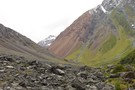
Death Valley
Photograph
•
Distance: 8.4km away
Death Valley is an offshoot of Kay Creek and makes an interesting and straight forward alternative to a crossing from ...
More ▶︎
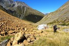
Scree Slopes in Hidden Falls Creek
Photograph
•
Distance: 8.5km away
An interesting mix of colours awaits you when you ascend Hidden Falls Ck toward Cow Saddle.
More ▶︎
Heading down Hidden Falls creek
Photograph
•
Distance: 8.6km away
Leaving the campsite in Cow saddle after a morning of relaxation and clothes drying. It's just an afternoons walk to ...
More ▶︎
Five Passes
Track
•
6 – 7 days. Medium/hard. Loop track.
•
Distance: 8.6km away
A classic trip starting and finishing at the Routeburn road.
The five passes are; Sugarloaf pass, Park pass, Cow saddle, Fiery ...
More ▶︎
Cow saddle
Photograph
•
Distance: 8.7km away
On the five passes route. Cow saddle with Fiery col in the background. taken Jan 2010
More ▶︎
Here comes the cold half of the day
Photograph
•
Distance: 8.7km away
We didn't start walking until after midday and now with the descent from Fiery Col complete we settle down in ...
More ▶︎
The tops of the Darran Mountains - Fjordland NZ
Photograph
•
Distance: 8.7km away
The exit from the Lake Nerine basin when heading to North Col overlooks the lower end of Hidden Falls Ck ...
More ▶︎
Ultramafic rocks, Hidden Falls Creek
Photograph
•
Distance: 8.7km away
On the five passes route. Ultramafic rocks in upper Hidden Falls creek. taken Jan 2010
More ▶︎
Morning mist, Hidden Falls creek
Photograph
•
Distance: 8.8km away
On the five passes route. Morning mist in upper Hidden Falls creek, not far from Cow saddle. taken Jan 2010
More ▶︎
Gill's Biv
Rock bivouac
•
Distance: 8.9km away
A large rock dropped of the Darran Range, located at the head of Lake Adelaide. Mike Gill identified the biv ...
More ▶︎
Hidden Falls Hut
Hut
•
Serviced Hut (DOC). Capacity: 12.
•
Distance: 8.9km away
Hidden Falls Hut (12 bunk, stove, firewood available) is a serviced hut about 1.5-2.5 hours from the Hollyford roadend on ...
More ▶︎
Camp on Hidden Falls Creek
Photograph
•
Distance: 8.9km away
looking upstream, our campsite high on Hidden Falls Creek was a little exposed but above the early morning mist
More ▶︎
Greenstone / Caples Tracks
Track
•
4 days. Easy/medium. Loop track.
•
Distance: 8.9km away
The Greenstone and Caples Tracks are often linked together to form a circuit from the shores of Lake Wakatipu. Long ...
More ▶︎
Mt Tutoko, Hollyford Valley
Photograph
•
Distance: 9.0km away
Mt Tutoko from Hollyford Valley
More ▶︎
fiordland for fun
Photograph
•
Distance: 9.1km away
Kevin and Jamie are the adventurers whose experiences are recorded in the 'First Crossings " TV series first shown on ...
More ▶︎
The Olivine Ledge
Photograph
•
Distance: 9.2km away
At around 1100M a grassy ledge takes you from a short distance down from Fiery Col to the outlet from ...
More ▶︎
Hobbs Bivvy, Routeburn North Branch
Photograph
•
Distance: 9.3km away
Great dry bivvy located under a giant boulder in the north branch of the Routeburn. Sleeps 4 or 5 but ...
More ▶︎
Hobbs Bivvy, Route Burn North Branch
Rock bivouac
•
Distance: 9.3km away
A dry and sheltered bivvy underneath a giant boulder in the North Branch of the Route Burn. Sleeps 4 or ...
More ▶︎
Kay Creek
Photograph
•
Distance: 9.4km away
Kay Creek, looking downstream from Kay Creek Hut
More ▶︎
Kay Creek Hut
Hut
•
Basic Hut/Bivvy (DOC). Capacity: 3.
•
Distance: 9.4km away
Kay Creek Hut (sleeps 3-4, fireplace, firewood available, creek water) makes up for in character what it lacks in comfort. ...
More ▶︎
Kay Creek - Upper Caples
Photograph
•
Distance: 9.5km away
April 2006 - Taken while coming back down Kay Creek to the Upper Caples DOC hut
More ▶︎
Scott Saddle route (Dart to Caples)
Track
•
1 – 2 days. Medium. One way.
•
Distance: 9.5km away
This route crosses the easiest pass from the Dart to Caples Valleys, via Scott Creek, Scott Saddle and Kay Creek ...
More ▶︎
Death Valley from Saddle
Photograph
•
Distance: 9.5km away
Death Valley is an offshoot of Kay Creek and makes an interesting and straight forward alternative to a crossing from ...
More ▶︎
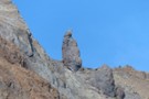
Menhir at Fiery Col
Photograph
•
Distance: 9.5km away
Approaching Fiery Col from the Olivine Ledge, there is a small but distinct menhir off to the right - Penguin ...
More ▶︎
Fiery Col menhir
Photograph
•
Distance: 9.5km away
Photo Feb 2013, having begun the climb from the Olivine Ledge towards the Col
More ▶︎
The Hidden Falls
Photograph
•
Distance: 9.7km away
Located on the Hollyford track about 3 hours from the carpark.
More ▶︎
Caples Track
Track
•
2 days. Easy/medium. One way.
•
Distance: 9.8km away
A quiet track climbing alongside the Caples River through forest and grassy flats and over a sub-alpine saddle.
More ▶︎
Upper Caples Hut
Hut
•
Club hut (Southern Lakes Deerstalkers Association). Capacity: 16.Bookings required.
•
Distance: 9.8km away
Comfortable hut in the Upper Caples Valley.
This hut was closed to the public in February 2014, but is now reopened ...
More ▶︎
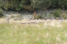
Caples Valley Fallow Deer
Photograph
•
Distance: 9.8km away
Spooked a mob of 30+ deer back in 06/07.
More ▶︎
Kay Lake and Death Valley Saddle
Photograph
•
Distance: 9.8km away
Death Valley is an offshoot of Kay Creek and makes an interesting and straight forward alternative to a crossing from ...
More ▶︎
Scott Basin
Photograph
•
Distance: 9.9km away
Scott Basin at the head of Scott Creek, between the Dart and Caples valleys. Scott Creek Hut (dilapidated) is located ...
More ▶︎
On the Serpentine Range 2
Photograph
•
Distance: 10.0km away
Looking north from near Point 1489 over the saddle at Point 1410. There is good looking camping on the saddle. ...
More ▶︎