Nearby
Tongariro Alpine Crossing
Whanganui National Park
Place
•
National Park. 742.31km2.
•
Distance: 6.1km away
Lowland forest surrounding the long and sinuous Whanganui River, the longest navigable river in New Zealand. New Zealand's 11th national ...
More ▶︎
Te Tatau Pounamu Wilderness Area
Place
•
Wilderness Area. 64.75km2.
•
Distance: 6.6km away
Forested northeastern slopes of the Tongariro volcano complex within Tongariro National Park.
More ▶︎
Tihia Track
GPX file
•
Distance: 8.4km away
A rough loop track and hard to find. But a worthwhile trip to a summit with good views
More ▶︎
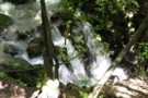
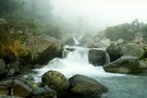
Small waterfall
Photograph
•
Distance: 8.5km away
A small waterfall below Ketetahi Springs, Tongariro.
More ▶︎
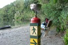
Ketetahi Track
Track
•
0 – 2 days. Easy. Return via same track.
•
Distance: 8.5km away
Easy climb through forest and subalpine vegetation on the northern flank of the Tongariro Volcano
More ▶︎
Into the wild
Photograph
•
Distance: 8.8km away
After the aptly named Devils staircase. A rewarding stretch in the clouds. Perhaps this could be renamed the stairway to ...
More ▶︎

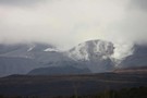
Tongariro Alpine Crossing
Track
•
1 day. Medium. One way.
•
Distance: 8.8km away
A popular but crowded alpine route through a spectacular volcanic landscape.
More ▶︎

Great Walks Information
Article
•
Distance: 8.8km away
The DOC Great Walks are a set of premium tramping tracks throughout New Zealand.
More ▶︎
Sunset at Ketetahi Hut
Photograph
•
Distance: 8.8km away
Earth's shadow rises on the sky beyond Lake Taupō.
More ▶︎
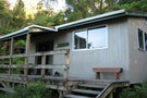
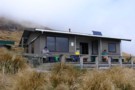
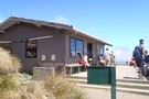
Ketetahi Hut
Hut
•
Shelter (DOC).
•
Distance: 8.8km away
KITETAHI HUT HAS NOW BEEN COMPLETELY REMOVED.
the toilets are still there
This hut on the northern slopes of Mt Tongariro ...
More ▶︎
Mangahouhounui Stream
Track
•
2 days. Medium. One way.
•
Distance: 8.8km away
An untracked alternative to getting from Ketetahi Hut to Oturere Hut and beats the madenning crowd.
More ▶︎
Ketetahi Hut
Photograph
•
Distance: 8.9km away
A modern great walk hut part of the Tongariro alpine crossing. A great place for and easy uncomplicated night out. ...
More ▶︎
Ketetahi Hut on a fine day
Photograph
•
Distance: 8.9km away
Looking North from Ketetahi hut towards Taupo
More ▶︎
The simple things in life
Photograph
•
Distance: 8.9km away
Tea break on a morning stroll Around Rotoponamu central North Island
More ▶︎
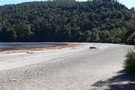
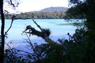
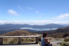
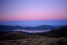
Lake Rotopounamu on an autumn morning
Photograph
•
Distance: 8.9km away
Looking out over the lake on a quiet sunny morning.
More ▶︎
Te Mari Craters
Track
•
Easy/medium. Return via same route.
•
Distance: 8.9km away
Unmarked walk to volcanic craters near Ketetahi Hut on the Tongariro Crossing
More ▶︎
Tihia Track
Track
•
Easy/medium. Loop track with a road section.
•
Distance: 9.0km away
A rough loop track and hard to find. But a worthwhile trip to a summit with good views
More ▶︎
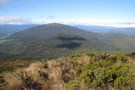
Pihanga and Lake Rotopounamu from the top of Tihia
Photograph
•
Distance: 9.0km away
One of the views from Tihia
More ▶︎

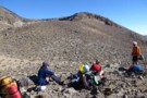
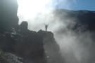
Having lunch at Upper Te Mari Crater May 2012
Photograph
•
Distance: 9.4km away
We had no inkling that the crater just above us would erupt in 3 months time.
More ▶︎
Te Mari Crater, post the August 2012 Eruption
Photograph
•
Distance: 9.4km away
Stll a fairly steamy scene
More ▶︎
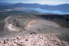
Sulphur Lagoon
Photograph
•
Distance: 9.8km away
One of the Te Mari Craters on the northern flank of Tongariro, near Ketetahi Hut.
More ▶︎