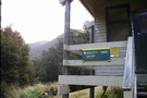
Nearby
Wangapeka Track
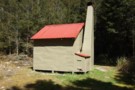
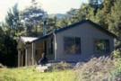
Great place for a snack
Photograph
•
Distance: less than 100m away
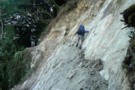
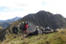
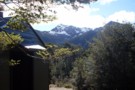
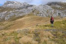
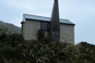
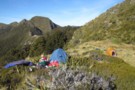
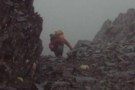
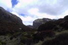
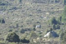
Doing my Garfield act on the last day of the Wangapeka
More ▶︎
Matiri Valley to Wangapeka Saddle
GPX file
•
Distance: 530m away
An interesting cross country trip in Kahurangi National Park
More ▶︎
Leslie-Karamea
Track
•
3 – 4 days. Medium. One way.
•
Distance: 831m away
Joins onto Wangapeka Track.
More ▶︎
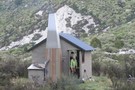
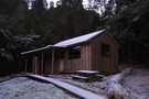
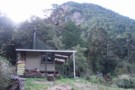
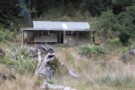
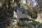
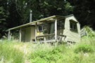
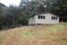
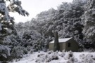
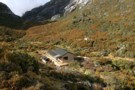
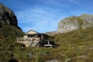
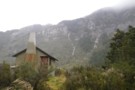
Bell Town hut Oct 2010
Photograph
•
Distance: 831m away
The place looks more inviting in this sunny day shot than in the early morning winter 2009 shot I posted.
...
More ▶︎
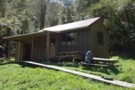
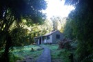
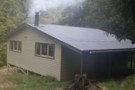
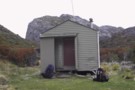
Bell Town hut June 2009
Photograph
•
Distance: 831m away
Picture of the hut taken early on a frosty morning.
More ▶︎
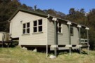
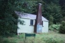
Rear view of Bell Town hut Oct 2010
Photograph
•
Distance: 831m away
Taken on a sunny day.
[Bell Town hut is located more or less right on top of an old prospectors camp. ...
More ▶︎
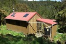
Bell Town / Manunui hut
Hut
•
Serviced Hut (DOC). Capacity: 10.
•
Distance: 831m away
A replacement hut for the Little Wanganui hut that was a little upstream on the other side of the river. ...
More ▶︎
Belltown Hut
Photograph
•
Distance: 854m away
Belltown Hut ... the western end of the ranges and the start of the brief coastal plain before the Tasman. ...
More ▶︎
Taipo hut Oct 2010
Photograph
•
Distance: 1.2km away
This is one of the last of the NZ Forest Service built huts before DOC days in the Nelson Conservancy ...
More ▶︎
Taipo Hut, Kahurangi
Hut
•
Standard Hut (DOC). Capacity: 16.
•
Distance: 1.2km away
Hut on the Wangapeka Track leading up to Little Wanganui Saddle. This is the last night before crossing the saddle ...
More ▶︎
Little Wanganui Hut (Removed)
Hut
•
Removed!
•
Distance: 1.6km away
Former hut on TL of Little Wanganui River.
More ▶︎
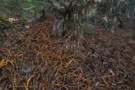
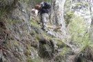
Forest devastated by Cyclone Ita
Photograph
•
Distance: 2.1km away
Forest devastated by Cyclone Ita - the south bank of the Little Wanganui - 1000's of hectares of bush with ...
More ▶︎
Stone Hut
Photograph
•
Distance: 2.4km away
On the Wangapeka track. Very cosy. Saw Whio in the river adjacent to the hut.
More ▶︎
Stone Hut
Photograph
•
Distance: 2.4km away
Not made of stone but lots of stones on the track upstram from here
More ▶︎
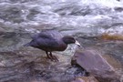
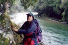
Blue duck / whio
Photograph
•
Distance: 2.4km away
The blue duck is an uncommon duck found on swiftly flowing rivers only in New Zealand. This one was swimming ...
More ▶︎
Stone Hut (Kahurangi)
Hut
•
Standard Hut (DOC). Capacity: 10.
•
Distance: 2.4km away
Stone Hut is situated on the banks of the Wangapeka River where it meets Stone Creek. The Wangapeka Track continues ...
More ▶︎
Matiri Valley to Wangapeka Saddle
Track
•
4 – 6 days. Medium. One way.
•
Distance: 2.4km away
An interesting cross country trip in Kahurangi National Park involving a stretch of unmarked ridge travel
More ▶︎
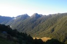
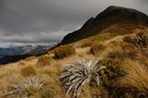
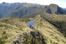
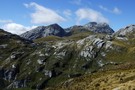
Wangapeka Saddle
Photograph
•
Distance: 2.5km away
Wangapeka Saddle from Nuggett Knob. Mt Luna to the right
More ▶︎
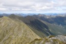
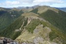
Matiri Wangapeka ridge from Nuggett Knob
Photograph
•
Distance: 2.5km away
This photo shows the whole ridge. Point 1442 above Hurricane Hut is in the middle and the tarn is on ...
More ▶︎
Nuggett Knob Close up
Photograph
•
Distance: 2.6km away
Only one more hill to go over before the Wangapeka
More ▶︎
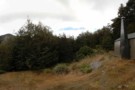
Stag Flat Shelter
Photograph
•
Distance: 2.8km away
This shelter replaced a hut that was nearby. It is on the edge of Stag Flat which is on the ...
More ▶︎
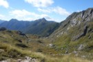
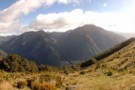
Looking down Kakapo River Oct 2010
Photograph
•
Distance: 2.9km away
This picture was taken soon after hitting the river after descending from Kakapo Saddle. Kakapo hut is about 3hrs down ...
More ▶︎
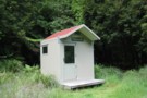
Stag Flat Shelter
Hut
•
Basic Hut/Bivvy (DOC). Capacity: 2.
•
Distance: 3.0km away
brilliant little 2 person shelter. taipo hut is boring and ugly so if you're heading towards the coast make the ...
More ▶︎
Stag Flat from the saddle
Photograph
•
Distance: 3.0km away
Stag Flat from the saddle between the Taipo and Little Wanganui. A tidy 2-bunk hut lies at the eastern end, ...
More ▶︎
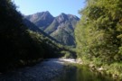
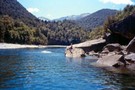
Little Wanganui
Photograph
•
Distance: 3.0km away
Little Wanganui valley ... and the Tasman, from the pass with the Taipo
More ▶︎
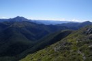
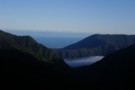
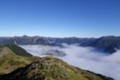
Looking SE over Zetland Basin Jan 2018
Photograph
•
Distance: 3.1km away
I took this photo when returning to the track after some time roaming the tops in the Mt Zetland area ...
More ▶︎
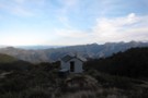
kiwi saddle hut
Photograph
•
Distance: 3.4km away
6 bed doc hut open fire water stunning veiws
More ▶︎
Kings Creek Hut
Photograph
•
Distance: 3.6km away
A large and rather clinical hut on the Wangapeka Track
More ▶︎
Kings Creek Hut
Hut
•
Serviced Hut (DOC). Capacity: 20.
•
Distance: 3.6km away
A large and clinical 1980s hut on the Wangapeka Track
More ▶︎
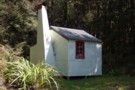
Cecil Kings Hut
Hut
•
Basic Hut/Bivvy (DOC). Capacity: 4.
•
Distance: 3.7km away
This historic hut is only a couple of hundred metres from the newer and larger Kings Creek Hut on the ...
More ▶︎
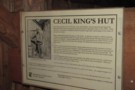
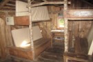
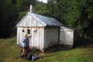
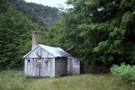
Cecil King Historic Hut
Photograph
•
Distance: 3.7km away
Built from the bush, a reminant from a past era
More ▶︎
Blue Creek Track
Track
•
Easy. Return by the same track.
•
Distance: 3.9km away
This short walk sets off from the site of a gold mining town, exploring mining relics and a river resurgence.
More ▶︎
Mount Owen - northern approach from Courthouse Flat
Track
•
1 – 2 days. Medium. Return via same track.
•
Distance: 3.9km away
Mount Owen (1875m) is the highest point in Kahurangi National Parks, a bare landscape of marble karst including New Zealand's ...
More ▶︎
Courthouse Flat campsite
Campsite
•
Basic Campsite (DOC). 25 spaces.
•
Distance: 3.9km away
Wide grassy camping in the Wangapeka Valley. A common access point onto Mount Owen via Granity Pass Hut. A number ...
More ▶︎
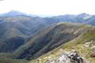
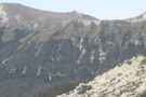
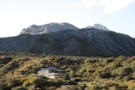
Mount Patriarch Tops
Photograph
•
Distance: 3.9km away
Mount Patriarch Tops, Kahurangi National Park.
More ▶︎
Fuchsia forest - route to Biggs Tops
Photograph
•
Distance: 4.1km away
Fuchsia forest - route to Biggs Tops
More ▶︎
Mt. Luna via the stone track
Track
•
3 days. Medium. 19hrs.
•
Distance: 4.2km away
Stone hut is a days march in from the Rolling river, taking the main Wangapeka track.From Stone hut ford the ...
More ▶︎
Siberia Flat campsite
Campsite
•
Basic Campsite (DOC). 40 spaces.
•
Distance: 4.4km away
Camping next to the Wangapeka River near the start of the Wangapeka Track.
Facilities include picnic tables nestled amongst trees ...
More ▶︎
Kiwi Saddle Hut (Wangapeka)
Photograph
•
Distance: 4.6km away
Kiwi Saddle Hut after a light overnight snow.
More ▶︎
Little Wanganui Gorge Shelter
Photograph
•
Distance: 4.8km away
Little Wanganui Gorge Shelter or Wangapeka biv. taken Jan 2015.
More ▶︎

Little Wanganui Gorge Shelter name
Photograph
•
Distance: 4.8km away
The latest name for Wangapeka biv, Little Wanganui Emergency shelter etc. Taken Jan 2015.
More ▶︎
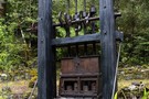
Culliford's Battery
Photograph
•
Distance: 4.9km away
A temporary four-stamper in Blue Creek near Mount Owen. A quartz reef was discovered here in 1870 by Alfred Culliford. ...
More ▶︎
Wangapeka biv June 2009
Photograph
•
Distance: 4.9km away
[Also known as Little Wanganui Emergency Shelter & Little Wanganui Bivvy]
This biv is situated in the headwaters of the ...
More ▶︎
Wangapeka biv
Hut
•
Basic Hut/Bivvy (DOC). Capacity: 2.
•
Distance: 4.9km away
[Also known as Little Wanganui Emergency Shelter & Little Wanganui Bivvy]
This biv is situated in the headwaters of the Little ...
More ▶︎
John Reid Hut
Hut
•
Standard Hut (DOC). Capacity: 6.
•
Distance: 5.0km away
Standard 6 bunk hut at approx 1240m. Great views to the East from the hut. Climb to the ridge above ...
More ▶︎
John Reid Hut
Hut
•
Standard Hut (DOC). Capacity: 6.
•
Distance: 5.0km away
John Reid hut. Standard 6 bunk hut. Water in small stream 20m towards toilet. Superb sunrises!
More ▶︎
John Reid Hut
Photograph
•
Distance: 5.0km away
Standard DOC hut in Kahurangi. Access Via the ridge from Mt. Patriach and Kiwi Saddle Hut or up from the ...
More ▶︎
Chummies Track
Track
•
Medium. Return by the same track.
•
Distance: 5.0km away
Marked tramping track to John Reid Hut and the Arthur Range tops. NB - the start of the track requires ...
More ▶︎
Kiwi Saddle Hut (Wangapeka)
Hut
•
Standard Hut (DOC). Capacity: 6.
•
Distance: 5.1km away
Six bunk hut in NZFS style. Tent sites available in clearing around hut. In early January 2007 there were a ...
More ▶︎

Trevor Carter Hut
Photograph
•
Distance: 5.2km away
Trevor Carter Hut, July 2009, I spent 2 days here waiting for the rain and thunder to stop.
More ▶︎
Trevor Carter Hut
Hut
•
Standard Hut (DOC). Capacity: 12.
•
Distance: 5.2km away
A new 12 bunk DOC hut on the Karamea River
More ▶︎
Biggs Tops
Photograph
•
Distance: 5.3km away
Biggs Tops looking into the Kendall Valley and down the Karamea River from behind Trevor Carter Hut.
More ▶︎
Mt Arthur to Murchison
GPX file
•
Distance: 5.4km away
track from Mt Atrhur Tablelands to Murchison via Wangapeka Saddle, Nugget Knob and the Matiri Valley
More ▶︎
Patches of bush on Matiri Range Dec 2017
Photograph
•
Distance: 6.0km away
This view shows the landscape of the Matiri Range and looks SW from near Point 1393m. You need to cross ...
More ▶︎
Camping by the Tarn on the Matiri Wangapeka Ridge
Photograph
•
Distance: 6.2km away
There was one established tent site and we found room for another tent.
More ▶︎
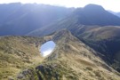
Tarn on the Matiri to Wangapeka ridge
Photograph
•
Distance: 6.3km away
This little tarn is the only water along the ridge and also makes a good camping spot if you want ...
More ▶︎
Tarn - Matiri Tops
Photograph
•
Distance: 6.3km away
Tarn, and sole campspot / water source on the Matiri Tops. 3km north of pt1442
More ▶︎

South Island Robin
Photograph
•
Distance: 6.4km away
A South Island Robin - Petroica australis australis
More ▶︎
Kakapo hut Oct 2010
Photograph
•
Distance: 6.5km away
Kakapo hut is near the river on the TL bank of the middle reaches of the Kakapo River. The Kakapo ...
More ▶︎
Kakapo hut
Hut
•
Basic Hut/Bivvy (DOC). Capacity: 4.
•
Distance: 6.5km away
Kakapo hut is near the river on the TL bank of the middle reaches of the Kakapo River. The Kakapo ...
More ▶︎
Larrikin Hut to Hurricane Hut via Mt Haystack
Photograph
•
Distance: 8.0km away
This pic is taken from point 1442 looking back towards Mt Haystack. The point on the skyline is 1411 on ...
More ▶︎
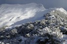
Luna Tops, Wangapeka
Photograph
•
Distance: 8.1km away
Overnight snow on the Luna Tops near Kiwi Saddle Hut, Wangpeka region
More ▶︎
Johnson River Oct 2010
Photograph
•
Distance: 8.7km away
This pic was taken about 10 minutes above Johnson hut on the lower reaches of the Johnson River. The prominent ...
More ▶︎
Johnson hut
Hut
•
Basic Hut/Bivvy (DOC). Capacity: 4.
•
Distance: 8.7km away
This is a 1957 vintage NZFS Nelson Conservancy design four bunk hut. It is located in a small clearing amongst ...
More ▶︎
Johnson hut Oct 2010
Photograph
•
Distance: 8.7km away
This is a 1957 vintage NZFS Nelson Conservancy design four bunk hut. It is located in a small clearing amongst ...
More ▶︎
Mt Owen via Sunrise Peak, return Fyfe Rive
Track
•
3 days. Hard. Loop track.
•
Distance: 8.9km away
Southern approach to Mt Owen, steep terrain, epic rock formations on the tops - making for stunning views but slow ...
More ▶︎
Branch Creek Hut
Hut
•
Standard Hut (DOC). Capacity: 6.
•
Distance: 8.9km away
Branch Creek hut
More ▶︎
granity pass huts
Photograph
•
Distance: 8.9km away
yes huts. For a brief period the old and new huts were present together on Mt Owen.
More ▶︎
Granity Pass Hut
Hut
•
Standard Hut (DOC). Capacity: 12.
•
Distance: 9.0km away
New DOC hut with 12 bunks. Rain catcher for fresh water only so you must go well supplied, can be ...
More ▶︎
Granity Pass Track
Photograph
•
Distance: 9.2km away
steep part of track leaving granity pass Hut
More ▶︎
Mt Owen - Fyfe River country
Photograph
•
Distance: 9.3km away
This photo has been posted to illustrate the "Track" article by "nshaw" about travelling between Mt Owen or Sanctuary Basin ...
More ▶︎
Hurricane Hut
Photograph
•
Distance: 9.5km away
A compact little hut in the head of the Matiri Valley
More ▶︎
Hurricane Hut
Photograph
•
Distance: 9.5km away
The hut can be seen from well down the flat, before you het there.
More ▶︎
Hurricane Hut
Hut
•
Standard Hut (DOC). Capacity: 4.
•
Distance: 9.5km away
A pleasant 4 bunker at the head of the Matiri
More ▶︎
Hurricane Hut
Photograph
•
Distance: 9.5km away
Hurricane Hut - tumbled limestone bluffs beyond
More ▶︎
Thor Hut
Hut
•
Standard Hut (DOC). Capacity: 6.
•
Distance: 9.8km away
A standard DOC hut on the Karamea River.
More ▶︎
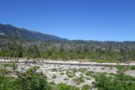
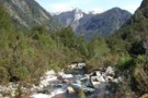
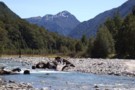
Karamea River
Photograph
•
Distance: 9.8km away
The legendary Karamea flows north, then suddenly turns west out to sea, (through grade 5 whitewater & a notorious gorge). ...
More ▶︎
Leslie-Karamea Track
Photograph
•
Distance: 9.8km away
A moderate 7-9-day tramp thru the heart of Kahurangi National Park, for experienced trampers with good gear and skills.
More ▶︎
Karamea Bend Hut
Photograph
•
Distance: 9.8km away
Sited adjacent to the Leslie River, this big barn is harder to heat.
More ▶︎