Nearby
Ahuriri
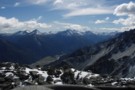
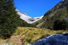
Picton to Aspiring
GPX file
•
Distance: 1.8km away
An aborted alpine traverse. Picton to West Cape, but aborted at Aspiring due to real world emergencies back home. Posted ...
More ▶︎
Shamrock Hut (Ahuriri)
Hut
•
Basic Hut/Bivvy (DOC). Capacity: 2.
•
Distance: 1.9km away
Shamrock Hut (2 bunks, matreses, fireplace, firewood avail., stream water) is an old station hut in the mid-reaches of the ...
More ▶︎
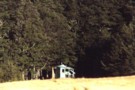
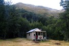
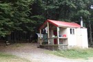
Shamrock Hut (Ahuriri)
Photograph
•
Distance: 1.9km away
Shamrock Hut in the Ahuriri - an old but comfortable 2-bunk station hut overlooking river flats and a small lake.
More ▶︎
Hagens Hut
Hut
•
Standard Hut (DOC). Capacity: 4.
•
Distance: 4.6km away
Small iron hut on the Ahuriri River flats.
More ▶︎
Hāwea Conservation Park
Place
•
Conservation Park. 1050.00km2.
•
Distance: 5.1km away
A large park at the head of Lake Hāwea between Mount Aspiring National Park and Ahuriri Conservation Park.
More ▶︎
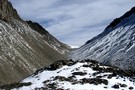
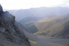
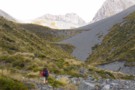
Little Canyon Col
Photograph
•
Distance: 6.4km away
Little Canyon Col - an alpine route over a tough pass from the Ahuriri to the Hunter (are there any ...
More ▶︎
A Temple - Maitland Circuit: the perils and joys of tramping in company
Article
•
Distance: 6.9km away
or ... 'He took me tramping and I cried'
Taking others tramping is for me, always an exercise fraught with doubt. ...
More ▶︎
South Temple - Watson Col
Photograph
•
Distance: 7.0km away
The col between the South Temple (SW branch from Sth Temple Hut) to Watson Stream (Sth Branch). A good, unmarked ...
More ▶︎
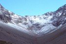
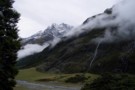
Hunter Valley from Little Canyon Col
Photograph
•
Distance: 7.6km away
Hunter Valley from Little Canyon Col: a tough pass between the Ahuriri and Hunter valleys (Shamrock Hut -> Scrubby Hut)
More ▶︎
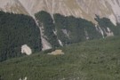
Maitland from Maitland -Temple - Watson saddle
Photograph
•
Distance: 7.7km away
The scree elevator down into the Maitland from the pass between Sth Temple, Maitland and Watson/Ahuriri
More ▶︎

Scree face from Watson/Temple into the Maitland
Photograph
•
Distance: 7.8km away
Scree face from Watson/Temple into the Maitland
More ▶︎
Maitland Hut (Ruataniwha)
Hut
•
Standard Hut (DOC). Capacity: 4.
•
Distance: 8.3km away
Maitland Hut is a typical 4-bunk forestry style hut in the Maitland valley. The hut's in a large clearing in ...
More ▶︎
Maitland Hut
Photograph
•
Distance: 8.3km away
Maitland Hut from the ridgeline crossing from Watson Stream. the hut lies in the large clearing.
More ▶︎

Top Hut - it's cold out there boss
Photograph
•
Distance: 8.4km away
What me, go out there in the cold?
More ▶︎
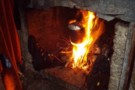
Top Hut - how to burn your boots
Photograph
•
Distance: 8.4km away
How to burn boots - a good fire in the Ahuriri Top Hut
More ▶︎
The Ahuriri from Top Hut
Photograph
•
Distance: 8.4km away
The Ahuriri from Top Hut (after a lot of rain!)
More ▶︎
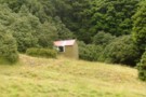
Top Hut (Ahuriri)
Photograph
•
Distance: 8.4km away
A 2 bunk hut at the top of the Ahuriri flats.
More ▶︎
Top Hut (Ahuriri)
Hut
•
Basic Hut/Bivvy (DOC). Capacity: 3.
•
Distance: 8.4km away
This hut now (Jan 2009) boasts 2 wooden bunks with matresses in place of the sack bunks described in 2005. ...
More ▶︎
Ahuriri Base Hut
Hut
•
Standard Hut (DOC). Capacity: 6.
•
Distance: 9.1km away
Hut by the Ahuriri River near the end of Birchwood Road. The hut was built in 1958 and has space ...
More ▶︎
Bull Flat Hut
Hut
•
Basic Hut/Bivvy (DOC). Capacity: 2.
•
Distance: 9.2km away
Small hut on the Hunter River.
More ▶︎
Temple - south branch
Photograph
•
Distance: 9.3km away
The south branch of the Temple ascending to to Temple - Watson - Maitland col and tarns
More ▶︎
South Temple (SW branch)
Photograph
•
Distance: 9.7km away
Tussock flats in the SW branch of the South Temple. A day return trip from South Temple Hut, or a ...
More ▶︎