Nearby
Mavora Lakes Walkways
Boyd Creek to The Divide via Kiwi Burn and the Mavora Walkway
Article
•
Distance: less than 100m away
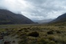
A New Year's trip through the Snowdon Forest and on to The Divide. Heavily affected by weather, I had to ...
More ▶︎
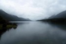
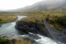
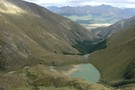
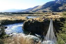
South Mavora Lake
Photograph
•
Distance: less than 100m away
A particularly wet New Year's Day at South Mavora Lake, looking up the lake from the swing bridge over the ...
More ▶︎
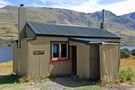
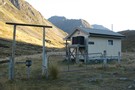
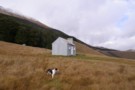
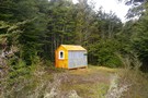
Careys Hut
Hut
•
Standard Hut (DOC). Capacity: 7.
•
Distance: less than 100m away
Hut at the head of North Mavora Lake on the Mavora-Greenstone Walkway. This corrugated iron hut includes both a coal ...
More ▶︎
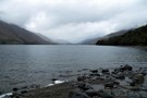
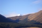
North Mavora Lake
Photograph
•
Distance: less than 100m away
The view up the North Mavora from near the boat ramp at the southern end of the lake on a ...
More ▶︎

Te Araroa Trail
Track
•
95 days. Medium. One way.
•
Distance: 899m away
Te Araroa is a walking trail running the entire length of the North and South Islands. The trail opened 3 ...
More ▶︎
Winton Burn and Mararoa from Mavora Walkway
Photograph
•
Distance: 1.1km away
Wind and rain swept vista from the bluffs above Careys hut on route to Boundary hut. The gully to the ...
More ▶︎
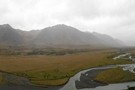
Mavora Walkway Country
Photograph
•
Distance: 1.7km away
Typical country that the Mavora Walkway passes through. Looking south down valley to avoid rain on the camera.
Jan 2014
More ▶︎
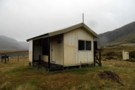
West Burn Hut
Hut
•
Basic Hut/Bivvy (DOC). Capacity: 6.
•
Distance: 2.1km away
Small hut on the western shoreline of North Mavora Lake. Note no toilet.
More ▶︎
Boundary Hut (Mavora- Greenstone Walkway)
Hut
•
Standard Hut (DOC). Capacity: 8.
•
Distance: 3.7km away
A hut on the Mavora-Greenstone Walkway on Mararoa River, beyond North Mavora Lake.
More ▶︎
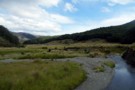
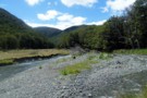
Kiwi Burn Swingbridge
Photograph
•
Distance: 5.6km away
The normal start of the popular Kiwi Burn tramping track. The bridge crosses the Mararoa River and then its a ...
More ▶︎
Ashton Burn, Eyre Mountains
Photograph
•
Distance: 6.2km away
The bottom end of Ashton Burn in the Eyre mountains. Do not be deceived by the broad valley at its ...
More ▶︎
Jane Peak, Eyre Mountains
Track
•
2 days. Medium. Return by the same track.
•
Distance: 6.2km away
The Eyre Mountains are located south of Lake Wakatipu, just next to the Mavora Lakes. Jane Peak is the highest ...
More ▶︎
Forks Hut (Mavora)
Hut
•
Basic Hut/Bivvy (DOC). Capacity: 4.
•
Distance: 6.7km away
Hut at forks on the Windon Burn north of the North Mavora Lake.
More ▶︎
Upper Oreti Hut
Photograph
•
Distance: 7.0km away
An old musterers hut in the Oreti Valley, Eyre Mountains - old but still homely and well used. An evenings ...
More ▶︎
Upper Oreti Hut
Hut
•
Basic Hut/Bivvy (DOC). Capacity: 6.
•
Distance: 7.0km away
A historic musterer's hut at the nth end of the Oreti valley in the Eyre Mountains. The hut has 6 ...
More ▶︎
Taipo hut
Photograph
•
Distance: 7.3km away
Northern most hut on the Mavora Walkway. Not in 100% condition, there is water damage to the hut floor from ...
More ▶︎
Taipo Hut, Southland
Hut
•
Standard Hut (DOC). Capacity: 8.
•
Distance: 7.3km away
Hut next to the Mararoa River, on the Mavora - Greenstone Walkway.
More ▶︎
Kiwi Burn from the North
Photograph
•
Distance: 8.1km away
Approaching Kiwi Burn hut from the direction of the Whitestone River, its visible on the tree line. The track snakes ...
More ▶︎
Kiwi Burn Hut
Hut
•
Standard Hut (DOC). Capacity: 12.
•
Distance: 8.2km away
Kiwi Burn Hut (12 bunks, wood-burning stove, water, firewood available) is a purpose built tramping hut located on the grassy ...
More ▶︎
Lincoln Hut
Photograph
•
Distance: 8.6km away
A basic 2-bunk hut in the Oreti River valley in the Eyre Mountains. The hut sits just inside the bushedge ...
More ▶︎
Lincoln Hut
Hut
•
Basic Hut/Bivvy (DOC). Capacity: 2.
•
Distance: 8.6km away
A basic 2-bunk hut at the mid Oreti valley, Eyre Mountains. The hut has an open fire but is otherwise ...
More ▶︎
Whitestone River
Photograph
•
Distance: 9.3km away
Pleasant walking to be had on either riverbank with plenty of good camping once above the farmland.
More ▶︎