Nearby
Korowai/Torlesse Tussocklands Park
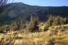
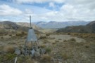
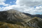
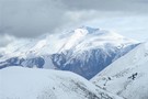
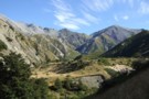
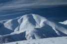
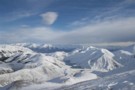
Bold Hill
Photograph
•
Distance: less than 100m away
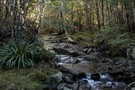
Looking at the North face of Bold Hill from the terraces above Broken River.
More ▶︎
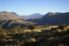
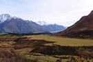
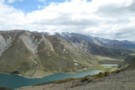
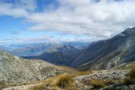
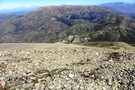
Craigieburn Valley
Photograph
•
Distance: less than 100m away
View North from the terrace above Avoca homestead
More ▶︎
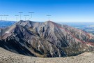
Mt Torlesse
Track
•
1 day. Easy/medium. Return by the same track.
•
Distance: less than 100m away
Noteworthy peak east of Porters Pass.
More ▶︎
Mt Lyndon
Track
•
0 – 1 day. Easy/medium. Return by the same track.
•
Distance: 2.0km away
Day trip of moderate ascent of 650 m hill overlooking Lake Lyndon near Porters Pass. Route goes via low open ...
More ▶︎
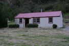
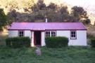
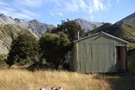
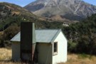
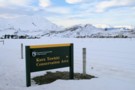
Avoca Homestead
Hut
•
Standard Hut (DOC). Capacity: 6.
•
Distance: 2.3km away
This hut is the restored homestead of the Avoca Run, at the junction of Broken River and Slovens Stream (not ...
More ▶︎
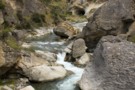
Dry Acheron Track
Track
•
1 day. Easy/medium. Return by the same track.
•
Distance: 2.8km away
Follow the Dry Acheron Stream to the summit of Big Ben (1416m).
More ▶︎
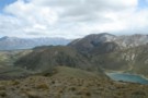
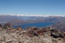
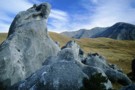
Lake Lyndon from Trig M
Photograph
•
Distance: 2.8km away
Beyond is Mount Lyndon and the Craigieburn Range.
More ▶︎
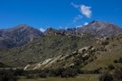
Red Hill from Trig M
Photograph
•
Distance: 2.8km away
Red Hill (1641m) is the highest peak to the right. The Lyndon Road winds past Lake Lyndon to Lake Coleridge ...
More ▶︎
Trig M
Track
•
Easy. Return via same track.
•
Distance: 2.8km away
An easy climb through subalpine scrub to a windy summit.
More ▶︎
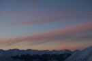
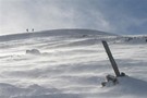
Foggy Peak
Photograph
•
Distance: 2.9km away
The climb up Foggy Peak follows Foggy Peak Ridge from the Porter's Pass road summit (visible lower right) to a ...
More ▶︎
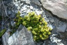
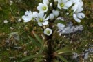
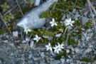
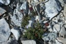
Geranium sessilifolium
Photograph
•
Distance: 3.0km away
Shingle river flats below Red Hill.
More ▶︎
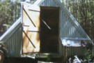
Inchs' Hut
Hut
•
Private hut (PVT). Capacity: 4.Bookings required.
•
Distance: 3.1km away
Rustic beech framed hut with tin cladding and roof built in 1973 I think by Gordon, Harold and one other ...
More ▶︎
Black Hill (2067m)
Photograph
•
Distance: 3.1km away
Just south of Lake Coleridge. Viewed from Trig M near Porter's Pass.
More ▶︎
Red Hill (1641m)
Photograph
•
Distance: 3.1km away
This hill just east of Lake Coleridge is a good day walk. Viewed from near Trig M, Porter's Pass.
More ▶︎
Torlesse Range Feb 2014
Photograph
•
Distance: 3.2km away
This photo is taken from slightly uphill of & beside the John Hayward Memorial Hut (Kowai Hut) in the Kowai ...
More ▶︎
John Hayward Memorial Hut
Hut
•
Private hut (NA). Capacity: 6.
•
Distance: 3.2km away
Also known as Kowai hut but not to be confused with Kowhai hut in the Kaikoura area near Mt Fyffe. ...
More ▶︎
John Hayward Memorial Hut Feb 2014
Photograph
•
Distance: 3.2km away
Also known as Kowai hut but not to be confused with Kowhai hut in the Kaikoura area near Mt Fyffe. ...
More ▶︎
Foggy Peak
Photograph
•
Distance: 3.3km away
From near point 1170, Porter's Pass, July 2009.
More ▶︎

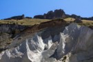
Patterned ground
Photograph
•
Distance: 3.5km away
Frost heave causes striping as the stones are sorted into smaller and larger. Ridge east of Red Hill.
More ▶︎
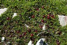
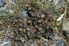
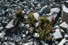
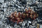
Coprosma atropurpurea
Photograph
•
Distance: 3.6km away
This Coprosma is very different from the native tree Coprosmas, but bears strikingly pretty, glassy berries. High in an alpine ...
More ▶︎
Red Hill
Track
•
1 day. Medium. Loop track.
•
Distance: 3.7km away
A largely untracked route up Red Hill (1,641m), with magnificent views of Lake Coleridge, and the surrounding foothills. This loop ...
More ▶︎
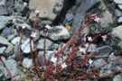
Gentiana montana
Photograph
•
Distance: 3.8km away
A particularly showy specimen, growing in a herbfield on Red Hill.
More ▶︎
Lobelia roughii
Photograph
•
Distance: 3.9km away
This tiny plant was widespread on Red Hill scree slopes
More ▶︎
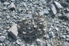
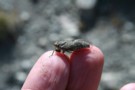
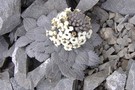
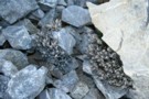
Scree buttercup (Ranunculus crithmifolius)
Photograph
•
Distance: 4.1km away
Located on scree just east of Red Hill.
More ▶︎
Epilobium pycnostachyum
Photograph
•
Distance: 4.1km away
Quite variable in colour from red to green, and scattered widely on scree at the saddle east of Red Hill.
More ▶︎
Kowai/Castle Hill Peak/Porters Pass Circuit
Article
•
Distance: 4.2km away
Circuit of the above. Can be done as a day trip or in our case, 2 days broken by a ...
More ▶︎
Pratia macrodon
Photograph
•
Distance: 4.3km away
This creeper was found growing around rocks and at the edges of stony areas on Red Hill.
More ▶︎
Castle Hill Peak
GPX file
•
Distance: 4.4km away
Straightforward alpine walk with great views.
More ▶︎
Pentachondra pumila
Photograph
•
Distance: 4.4km away
These mats covered much of the ground on a low ridge near Red Hill.
More ▶︎
Red Hill
Photograph
•
Distance: 4.6km away
View towards Lake Coleridge from the Summit of Red Hill.
More ▶︎
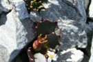
Leptinella atrata
Photograph
•
Distance: 4.6km away
A curious black flower on the summit of Red Hill.
More ▶︎
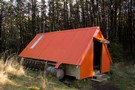
Walker Hut
Hut
•
Basic Hut/Bivvy (DOC).
•
Distance: 4.8km away
Hut on the Waimakariri Gorge near Broken River, part of Oxford Forest Conservation Area.
More ▶︎
View Hill, Kinnebrooks Hut, Fosters Hill, Black Hill, View Hill circuit
Article
•
Distance: 5.0km away
2 day circuit from View Hill in Mt Oxford Forest Park, travelling down to the Waimak gorge and a well ...
More ▶︎
Benmore
Article
•
Distance: 5.0km away
A seldom used track to a cosy hut in the Benmore range
More ▶︎
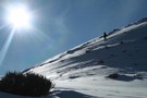
Foggy Peak
Track
•
Easy/medium. Return via same track.
•
Distance: 5.4km away
A short walk from Porter's Pass to a peak with good views at the southern end of the Torlesse Range.
More ▶︎
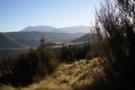
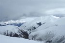
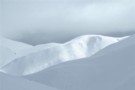
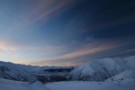
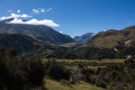
The Big Ben Range from Foggy Pk
Photograph
•
Distance: 5.4km away
Looking across Porters Pass in the Canterbury high country.
Kowai Forest is a very accessible point from which to explore the ...
More ▶︎
Broken River Hut via Cave Stream
GPX file
•
Distance: 5.5km away
Alternative route to Broken River Hut. Land owners' permission needed.
More ▶︎
Near Broken River Hut
Photograph
•
Distance: 5.6km away
The view up Winding Creek to Purple Hill from one of the terraces above the hut.
More ▶︎
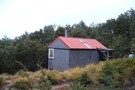
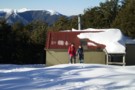
Broken River Hut
Photograph
•
Distance: 5.7km away
This little hut sits on a sunny terrace and a coal seam. The layers exposed here are part of the ...
More ▶︎
Broken River Hut
Hut
•
Basic Hut/Bivvy (DOC). Capacity: 4.
•
Distance: 5.7km away
Located upstream of Avoca Homestead.
More ▶︎
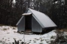
Broken River hut Feb 2012
Photograph
•
Distance: 5.7km away
This 1960 vintage NZFS 4 bunker is about 1.5hrs upstream from the Avoca Homestead hut. There are various coal mining ...
More ▶︎
Mt Plenty, Ghost Creek Circuit
Article
•
Distance: 6.0km away
A day trip involving a 700 m climb then descending a creek with 2 challenging sidles past waterfalls.
More ▶︎
Annavale Circuit from Benmore Hut
Article
•
Distance: 6.4km away
A new track enabling a circuit as a day trip or an easy weekend trip. Plenty of tracks to explore ...
More ▶︎
Benmore Hut
Hut
•
Basic Hut/Bivvy (DOC). Capacity: 3.
•
Distance: 6.4km away
3 person little hut installed by Malvern Deerstalkers in 1975.
More ▶︎
Benmore Hut
GPX file
•
Distance: 6.6km away
Short walk to a deerstalkers' hut in Thirteen Mile Bush.
More ▶︎
Mt Enys - Finally!
Article
•
Distance: 7.7km away
An account of our 4 attempts to climb Mt Enys directly via Deadman Spur.
More ▶︎
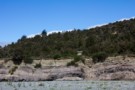
Thirteen Mile Bush
Photograph
•
Distance: 8.0km away
Beech forest on the walk into Benmore Hut.
More ▶︎
Striking limestone formations of Castle Hill
Photograph
•
Distance: 8.1km away
Known as Kura Tawhiti to Ngāi Tahu, this is an area of historic significance, with rock drawings hidden amongst the ...
More ▶︎
Prebble Hill (902m)
Photograph
•
Distance: 8.5km away
Red Peak (1853m), The Gap, and Castle Hill Peak (1998m) behind.
More ▶︎
DOC sign
Photograph
•
Distance: 8.6km away
Kura Tawhiti Conservation Area is the karst landscape also known as Castle Hill, located on the road between Porter's and ...
More ▶︎
Black Hill
Track
•
2 days. Easy/medium. Return by the same track.
•
Distance: 8.8km away
A straightforward overnighter in the dry beech forests around Mount Oxford.
More ▶︎
Black Hill Hut
Hut
•
Standard Hut (DOC). Capacity: 6.
•
Distance: 8.8km away
Six bunk just below the bushline in dry beech forest on Black Hill. Enclosed wood burner, rainwater supply; nice and ...
More ▶︎
Black Hill Hut, Oxford Forest
Photograph
•
Distance: 8.8km away
Six bunk hut just below the bushline
More ▶︎
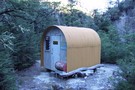
Salmon Creek Lower Bivvy
Hut
•
Basic Hut/Bivvy (DOC). Capacity: 2.
•
Distance: 8.8km away
Last model of NZFS 2 person bivvy (as per Bob's Biv). Curved, corrugated iron cladding with internal plywood lining of ...
More ▶︎

Wharfedale Hut / Black Hill Hut loop and return
Track
•
2 – 3 days. Easy/medium. Return via same track.
•
Distance: 9.5km away
We were waiting for a good settled weekend to get into the hills. Alot of snow damaged branches along the ...
More ▶︎
Black Hill hut in Winter
Photograph
•
Distance: 9.5km away
Boys at Black Hill hut with a view of Mt Oxford
More ▶︎
Black Hill hut in Winter
Photograph
•
Distance: 9.5km away
Boys at Black Hill hut with a view of Mt Oxford
More ▶︎