
22nd June 2012. Mackintosh Hut
I finally reach the roadend at 2:30pm – quite an achievement after a 4:30am departure for an early start on the hill.
====
Midnight Friday morning, and I’m lying in bed wide awake – stressing. Knowing full-well that it’ll be hours before I can relax, or become tired enough to sleep. Knowing that with every hour I spend awake, the state I’ll be in tomorrow for work will be so much worse. Knowing the complicated tasks that need to be finished will take that much longer; will have that many more mistakes to be corrected. Knowing that every interruption will jar, delay that bit more. Knowing my chances of getting out of there early for a weekend’s tramping are slowly ticking their way out of the proverbial door.
Stuff this: no point lying here awake worrying. Wide awake now, so might as well go to work and get it done.
4:30am. Job done. What were you stressing about Pom?
====
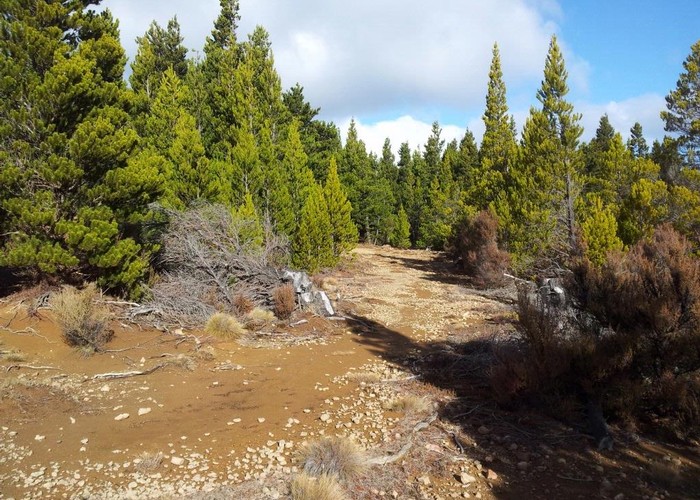
Heading over the
I see they’ve installed little solar lights along the crash barriers above the drop-offs. They must have sensors to turn off in daylight, as they go off when your headlights get near to them. I wonder if they are also triggered to turn on only for approaching vehicles, or stay on all night. I crane my neck to try and see if the ones behind me are still lit after I’ve passed, but can’t see. Returning my gaze to the road in front of me, and swerving back onto the correct side of the road, I wonder how many lives they’ll save.
Tramping: trouble is the forecast is atrocious. Severe rain warnings all the way up the west coast of the
I pass Masterton a little after 5:30am and the eyelids are beginning to droop. So stop for a couple of hours sleep in a layby. Much revived continue north at 7am in the first light of the day, grabbing a couple of pies for breakfast. By Norsewood I’m regretting the pies: stomach is churning, and the van has a fetid, burnt-rubber smell that I associate with the rear end of sick dogs. Finally arrive at the T junction to turn left to the Gentle Annie road or right to
Smoke drifts leisurely from under the van, accompanying the tick-tick of hot metal cooling. The mechanic/owner wanders over and confirms with a yelp that the gearbox is indeed hot. A streak of smoking oil spreads in a V from the rear of the gearbox to the back of the van. Things don’t look good.
The mechanic is a hero however. Within minutes he’s on the phone to wreckers and reconditioners looking for a replacement box. By lunchtime he has one organized to be fitted Monday. The Kawekas are back on the agenda, if only I can get there. I inquire about the chance of a courtesy car. He looks worried; looks at the selection of battered and part dissembled vehicles that lie behind the workshop. ‘Nothing that’ll get you that far’, he admits. But he runs me over to a car-hire company instead.
All of which cheers me up. The weekend of tramping looks like it is going to cost me in the region of $2000, but look on the bright side: it’s just become a 4-day weekend, as the van will no be ready until late Monday.
====
So 2:30pm sees me finally step from the hire-car at the
The shortest route to Mackintosh Hut seems to be up the riverbed, but a 2m-wide recently recut track heads up 100m onto the ridge before dropping back to the river and climbing to the Mackintosh plateau. My feet are still dry, and the cut track looks inviting, so I take that – heading briefly down river before starting to climb. It’s only 100m to the ridgeline, but legs have become used to desks, not hills in the last few weeks of inactivity. But we get there.
There are good camping spots beside the
The climb up the far side to the Mackintosh plateau is 450m and steep, despite benched zigzags which manage to more than double the distance without seeming to reduce the gradient. Sweat is expended, but it’s close to dusk and an unseen fiery sunset paints the manuka and clay-pan landscape in gold.
The manuka has diminished in size by the time I reach the plateau – sparse scrub remaining, contorta pines filling the gaps. It’s an alien landscape: unfamiliar to me as well as exotic to
The map shows the track following the escarpment towards Mackintosh hut, but on the ground it feels more like I’m crossing the middle of a large plateau as I make haste northwest in the little light of the day which remains.
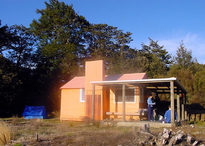
On the ground, the descent to Mackintosh hut is barely noticeable, so I’m surprised when I look up and see the hut sitting across a small creek, just 2¼ hours after leaving the roadend. It’s a lovely spot: tucked against the beech forest, sheltering the hut from the west – looking out over a large clearing to the east. A huge deck, roof supported on deer-posts, covers the front and one side of the hut - sheltering a tank-fed sink. Inside Mackintosh is spacious: sleeping 8 on two platforms at the east end, a great cooking stove in the opposite corner, a cooking bench, large table. Comfortable.
The place is soon warm and tea cooking on the stove - and remains warm throughout the night, despite a moderate frost outside. I’d hoped to be on the tops at Dominie Biv tonight – for a quick crossing to Middle Hill before the bad weather arrives tomorrow lunchtime. But Mackintosh is a lovely hut in a lovely spot, and I can’t find it in me to be disappointed at my lack of progress.
23rd June 2012. Middle Hill Hut.
1pm. Woke at 7:05am after 11 solid hours of sleep: the catch-up I needed. Missed the weather forecast on the radio by 1 minute, but outside the skies are blue, interrupted only by a few streaks of high cirrus. The wind of the previous evening is gone. I sit on the deck in morning sunshine, listening to the birds and the chatter of the creek. It’s going to be a good day.
The plan was to take the ‘low route’ to Makahu, then up the Dominie spur, weather permitting, for a brief dash over the tops to Ihaka Spur and Middle Hill Hut. But I can’t waste weather like this down on the flats in the manuka bush.
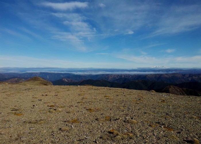
So 8am sees me, in shorts and T-shirt, sweating my way up Mackintosh Spur to the Kaweka tops. The beech gives way to manuka at the base of the hill, which is soon overwhelmed by contorta as the altitude rises. The track continues wide and well-cut: a tunnel through pines, opening to red clay-pan and rock, closing in again. Always climbing. I’d always viewed the Mackintosh plateau as low – far below the ridge – but the climb is only 450m and soon I’m there where the pines stop abruptly at the summit of main ridge. I poke my nose out onto the tops, scuttle back down 10m to reorganize and regroup. Polyprop and fleece go on, and I stick my nose out again for maybe 20 seconds this time, then retreat. Minutes later, clothed in long-johns, polyprop, fleece, winter coat, gloves and beanie I try for a third time. A bitter southwesterly wind whips across the ridgeline, taking breath and freezing nose and fingers. The hood goes up, is battened down on the upwind side: I’m as ready as I’ll ever be, but it is still a hard, cold climb to Mad Dog summit.
To the west, threads of cloud form narrow rivers above the valley floors, but the tops are clear. Ruapehu and Ngarahoe glisten ice-clad in the sun. As ever the sun shines on Hawke’s Bay – I fancy I catch the flicker of sunlight on breaking waves along the coast. A beautiful day - except the mercury says -2ºC and it’s blowing a gale.
The mud-scree slopes of Mad Dog are frozen – each pebble sits atop an inch-tall pillar of ice – crumbling, crushed with every footstep. Underneath the mud is unfrozen, slippery – the ice-axe invaluable despite the lack of snow.
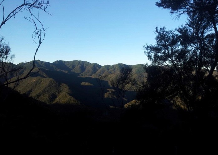
I crest the ridge onto the flat tops between Mad Dog and Kaweka J expecting the worst, but instantly the wind drops. The howling gone from my ears, no longer tugging at pack and clothes, no longer trying to tear me from the ridge. It makes for a pleasant stroll across the barren, fine-stony tops to Kaweka J. Patches of snow shelter from sun and wind in hollows, but there’s nothing to show that it’s late June. Beyond the range, to the north, rain-heavy clouds covers the Maori land south of Taupo – curtains of rain at their front. To the west Ruapehu struggles to remain above rising valley-cloud - rallies, fails and is gone. But the valleys of the Kawekas remain clear, bathed in sunshine. I tramp on top of the world, surrounded by cloud, under an island of blue sky. I’m in the right place.
I intend to drop to Dominie for lunch, but the encroaching bad weather dissuades me from an hour-long detour. And after all, it’s still early to eat. Dominie can remain as a tempting destination for another day. Each time I visit the Kawekas I know for certain that I’ll be coming back again.

The tops all the way to Whetu are barren – fine rock and dirt, occasional alpine plants crouching low out of the wind. The track is marked by frequent warratahs, and clear on the ground. Small engraved steel signposts mark each track junction – presumably the normal wooden variety proving too susceptible to the wind on these exposed tops. Three saddles break the main ridgeline, each 100m or so below the tops, and soon the layers of clothing start to come off with each climb. A change to the northwest has blunted the bite of wind, but the cloud to the north is rapidly heading this way – walls of rain moving down the Mohaka Valley.
There are 2 descents to Middle Hill: Ihaka Spur and
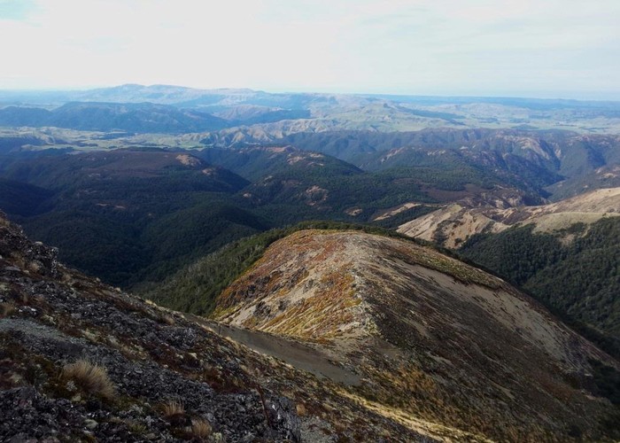
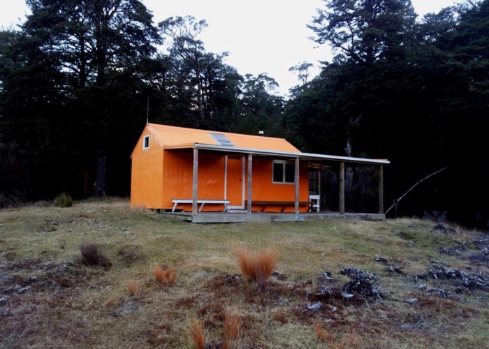
Middle Hill: Yet another comfortably, well maintained Kaweka Hut. I’m impressed. Again, the large covered deck frames two side of the original hut. Six bunks, sadly of sagging iron – the mattress will be on the floor tonight. A large open fire dominates one wall – you just know from looking it will smoke unless the door is kept open. The surprise is the amount of use the hut gets. I’ve always viewed Middle Hill as an out-of-the-way spot several km form the main ridge, on a track-to-nowhere, surrounded by think, unhuntable scrub. Who’d go there? But barely a weekend goes by year round without someone being present, and in summer the hut is often full. Mainly used by hunters, in from the roadend 3km east, it’s a busy spot. I hope that the atrocious forecast will keep them away this weekend. It seems to work.
24th June 2012. Black Birch Bivouac.
2pm. The forecast rain seems to have finally arrived over the main
I woke this morning to a faultless blue sky. One last remaining star shone – it’s bright pinprick the only flaw in a ceiling of blue. The ‘two days of rain and gales’ seem to have passed overnight. Sleep first stirred by the drumming of rain on Perspex, then destroyed by the boom-boom as the chimney flexed against the side of the hut with each increasing gust of wind. As
Again, 8am sees me leave the hut and start the 1km stroll back up the track to the Maheku / Kaweka flats turnoff. Cresting the first rise gives the opportunity of an uninterrupted view of the main
From the junction the track south drops to the first of two small streams, returning after each to the plateau that makes up much of the eastern Kawekas. The descents and climbs are easy, the track broad and well cut through open beech.
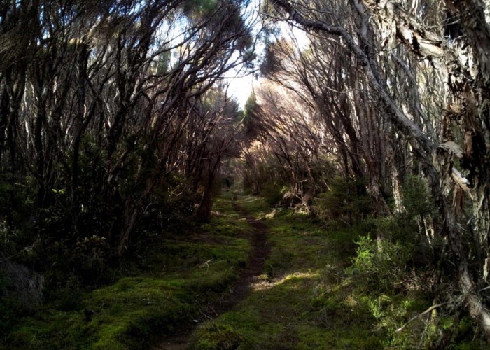
A couple of km later, the beech again makes a sudden change to manuka. The track starts to drop steeply down a mud-gravel spur. A deep V-notch valley opens in front, below. The 2m wide cut track vanished, replaced by a narrow foot-worn trail, zigzagging down ridgeline, slip, and finally dropping steeply though slippery beech forest to the
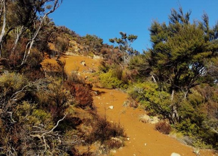
The river is unbridged but low, I’m able to cross easily with still-dry feet, though the deep riverbed hints of impassible flows after storms. Large triangles lead 50m downstream to where the narrow trail resumes, climbing what appears to be a steep streambed before finding a ridge to follow back up towards the plateau above. Nearing the summit we leave the thick scrub and enter a landscape of fiercely orange clay-pan, a landscape that could only be here. Looking later at my map, I see it is completely wrong about the position of this ascent, showing the track leading upriver some 400m to another spur.
Having 4 days on my hands, I’ve been looking forward to the challenge of tracking down the historic Iron Whare, some 1km off the main track. I’m slightly disappointed then, to crest the plateau and find a standard engraved-steel Kaweka signpost saying ‘Iron Whare’ and pointing east down a well-cut DOC track. Them’s the breaks.
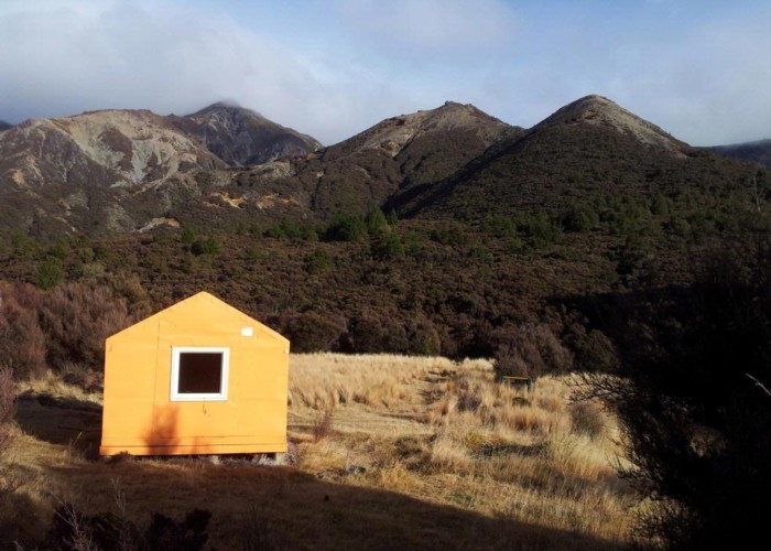
Before Iron Whare though, a visit to Kaweka Flats Bivouac. Leaving the tongue of beech that marks the escarpment, the track enters a boggy plateau of stunted manuka, in places opening to marshy tussock flats which small muddy streams fail to drain. The cloud remains over the main range – higher now allowing views of the peaks. Walls of fine drizzle make rainbows, cause the tussock to sparkle in the sun, but fail to dampen either the bush or my spirits. Crossing another small stream, the manuka opens to a large, green clearing of short grass. Set back against the eastern edge, Kaweka Flats Biv stands out orange in the sunlight. A typical dog-box biv, sleeping two on the floor; water from the creek. The usual outdoor fireplace that accompanies most Kaweka biv’s is absent, but the paddock-like grass flats appear purpose-made for camping. A sign says only 1.5 DOC hours to the Makahu roadend.
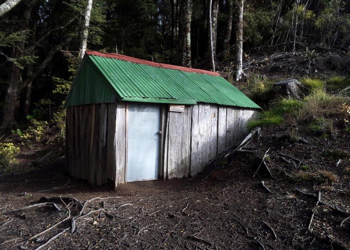
Back at the turnoff, the good, cut marked track to Iron Whare follows the escarpment though beech forest to the hut. Flat and broad, the plateau narrows to a ridge just shy of Iron Whare, and starts to drop. I expect a historical ruin, but the hut is in great shape. Cut into the hillside, looking out over the Makahu and the plains beyond, it is in a great spot. The walls of the Whare are rough-sawn slabs of local timber, the rear wall of flattened packaging tins. Roofing iron is the only commercial building product used. The floor is dirt, and two wooden slat bunks make up one wall – sadly without mattresses. Old wooden nail-boxes improvise as chairs. The longdrop – the unwalled, unroofed, sit-on-the-box-and-admire-the-weather variety, is 100m further down the ridge,. Sadly, the striking absence is water. There appears to be none at the hut, and the nearest stream on the map is 40 vertical meters below in the valley floor. Surely there must be water closer than that…?
Could covers the Hawke’s Bay and it feels as if the forecast rain will arrive soon, so I grab a quick lunch and move on. The route of an old benched track or road heads down the ridge from the hut, passing the longdrop. On satellite photos this track/road is clear, descending all the way to the forks east of the hut. On the ground, however, it quickly become overgrown on leaving the beech, though frequent marker tape helps for a while after which you are left to follow the ridge. Abruptly the ridge stops and drops. On the forementioned satellite photos the track appears to zigzag down the northern face to the forks. I, however, turn south to pick up a side spur heading towards the base of a long slip on the opposite face which promises a good clear route up to
From here it should be a 200m stroll west along
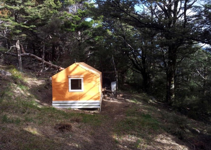
The Black Birch Ridge track starts across a small beech gully before becoming a wide cut canyon though the manuka scrub to the ridgeline. Here it joins what appears to be an old 4WD track heading south along the summit. First through swamp and tussock, this dries increasingly to barren claypan before the contorta takes over. In places: low, stunted, scattered; in other mature – the track a dimly lit tunnel on a bed of needles beneath the pine canopy. It is very easy going along the stony gravel surface, climbing slowly to the evocatively named summit at ‘G no. 2’. The turnoff to Black Birch Bivouac lies just beyond.
Lying to the west of the ridge, just where the contorta give out to a wall of beech, this is another typical Kaweka dog-box-biv. Door, window, roof high enough to sit comfortably inside. Two mattresses on the floor. Water 50m away down the hill. Cooking fire and grill outside, shielded by an iron back from the westerly. Functional and livable. But confining and miserable if it rains.
It’s only 2pm when I arrive. I light a cooking fire, make coffee, read a little. The main range opposite disappears again into cloud, reappears two hour later clad in white. Glad I’m here, not there.
25th June 2012 Black Birch to
A cold night and a colder morning at Black Birch Biv. The clear sky in the east still doing battle with the rain over the ranges as I climb the short track back to the ridgeline and continue my way south. Protected from the westerly by the pines, it is a pleasant walk. Soon a large grassy clearing appears ahead, scattered with a few lone mature pines. A signpost points left to the Lotkow road.
All along Black Birch Ridge I’d assumed I was walking along the boundary between an exotic pine plantation and the native bush of the Kaweka Forest Park. Had believed that the tangled contorta pines spilling over the ridge were just that:- an incursion from a neighbouring block of their kin. But as the track drops off Black Birch Ridge the valley below is revealed – an unbroken sequence of native bush: beech, manuka, cabbage trees and ferns - not a pine in sight. So the dense pine colony on the ridge is just that: an invasion from afar, taken hold in the most exposed vulnerable spot on the ridgeline, now working its way down into neighbouring denser vegetation.
The descent is steep and slippery, but the track well cut as it drops down the narrow spur. Lower, the spur levels, become a ridge dividing the valley into two separate catchments, one flowing north, one south. A gravel road climbs from the valley floor to the north to meet us.
My map shows a tramping track continuing south along this ridgeline, climbing with it whilst the road remains below and sidles the face, but no obvious sign of this track was visible on the ground. Instead I continue along the gravel road, sidling the hillside until the valley floor rises to meet us just short of the valley head. A couple of slumps and slips just short of the roadend have closed the vehicular route. An orange netting barrier blocks access, tire tracks of vehicles threading a tight slalom between the road barrier and the crumbling roadedge.
The road ends at a gravel carpark, green with grass and moss from lack of use. Ahead the walking track climbs through a dark dim tunnel in the damp bush. The place feels nothing like the Kawekas. Ferns dominate, everything damp, lush, green. Creepers climb the larger trees, tangle in the space between them. Epiphytes perch on larger trunks. A rain forest, just one ridge from a clay-pan, rock and scrub desert,
The track climbs for a few hundred yards to a saddle, steep and slippery on the bare mud surface. A track branches west, signposted Don Juan. Ahead, the track to
We follow the eastern valleyside to a fork where the river swings west, cross a sidestream, and climb briefly to reach the saddle where just 2½ days ago I turned left towards the
====
- Lawrence Roadend -> Mackintosh: Good track - 2.25 hrs
- Mackintosh -> Kaweka J: Good track to ridgeline. Poled route beyond - 2.5 hrs
- Kaweka J -> Whetu summit: Ridgeline route - 1.5 hrs
- Whetu Summit -> Middle Hill Hut: Good track - 1 hr
- Middle Hill -> Kaweka Flats Biv: Good track but rough/steep crossing Nth Makahu - 2.5 hrs
- Kaweka Flats Biv -> Iron Whare: Good track - 30 mins
- Iron Whare -> Whittle Rd fire dam: marked bush route - 1.5 hrs
- Whittle Rd -> Black Birch Biv: Good track - 1 hr
- Black Birch Biv -> Lotkow rd: Good track, steep descent - 1 hr
- Lotkow roadend -> Lawrence roadend: Good track except 1km of riverbed travel - 2 hrs
- Lawrence Roadend
- Mackintosh Hut
- Makahu Saddle
- Kaweka Flats Biv
- Middle Hill Hut
- Iron Whare
- Black Birch Biv
- Lawrence Roadend