One of life's little goals is visiting all the huts in the Tararuas that I have not yet been to (extended somewhat by having started on the Haurangis in the meantime, for a bit of variety). Rather pointless: I know, but it's an excuse to get me out there, which is what I need. However, with 39 down and 9 to go in the Tararuas, we're getting to the stage where there is generally a very good reason I haven't been to those places that are left. Either they're locations I've had no interest in visiting, or they're very remote, hard to get to, and I've never figured out a way of incorporating them into a trip. Naturally, category 2 is getting the priority attention, as I love a challenge.
The Tararua Range actually consists of two parallel ranges starting in the south, and meeting at Arete peak in the north of the park. In between these two ranges lies the Waiohine River gorge.
The ranges fluctuate between 1200m and 1500m of altitude - a height at which they are mostly tussock-clad and clear of trees, giving great views to both coastlines, to the South Island, and as far north and west as Ruapehu and Mt Taranaki on clear days. I say mostly, because the ridgelines also dip in places into the cloud forest - an equally rewarding experience. If you've not met this, this is a thin stratum of stunted beech trees clinging to exposed ridgelines around 1100-1200m. The Tararua ridgelines are rocky, generally knife-edges, and great fun to walk along. The trees are generally 3-4m high, but of normal diameter: 50cm or more. They fork repeatedly and low to the ground, and have no leaves below the low, thick canopy - making them in places an army twisted, deformed creatures. But what makes the cloud forest special, is the moss. Everything, absolutely everything is covered by a thick carpet of verdant moss. 10cm or so thick, deep green, and covering trees, rocks, ground, everything. It is a primeval place.
The Waiohine river, by contrast sits at the bottom of its gorge, 200-300m above sea level. There's generally less that 1 horizontal kilometer between the river and the surrounding ridgelines - making it an extermely inaccessible place. Which is, for the most part, fine: even if you were to get down there, there's no flat land to stand on that isn't occupied by river. Except for one spot: a flat 1km long by 200m wide lies on the eastern bank of the river, right in the middle of the gorge. And here, in this welcoming, sunny spot (sarcasm), the NZ Forest Service chose to build Mid Waiohine Hut.
Two options exist to get to this remote spot: either drop 1200m near vertically off either surrounding range, or swim. It being mid-winter, I went for option a).
====
Into Sayer
5pm on Friday nights, as all weekday nights, marks the start of the daily drag-race-come-hill-climb that is the daily commute over the Rimutaka Hill Road (remember all those wiggles from the Wairarapa to Upper Hutt?). Carried out at the limit of tyre traction, and by a group of people who must have a pathalogical hatred of trains or tunnels to do this trip daily by car, it's a terrifying experience. So I slink off work at 2pm, and beat the rush.
I'm in two minds for a start point - Mangaterere roadend, or the Waiohine Gorge. The latter will give me an easy walk up the flats to Totora Flats Hut on Friday night - and more importantly an easy walk back out on Sunday. But I long to visit the more interesting Sayers Hut on the opposite river bank, accessible over the 750m range behind it from Mangaterere - and so in the clear knowledge that 'you'll regret this come Sunday evening' I head for Mangaterere. The carpark is a grassy river flat and decidedly soft looking. I locate a hummock 10m off the road and execute a 20-point turn without the wheels leaving the gravel - then reverse madly to get off the road and up the slope for a downhill exit on Sunday. Even so, I have visions of returning Sunday after rain to find the van sunk to it's chassis in the soft riverside ground.
The climb is not exciting - the whole area has been logged and it's a steady rise though regenerating bush to reach the 750m ridgeline on dark. An important lesson in common sense is the only event of the trip. I have a habit when walking up steep hills of putting my hands on my hips which helps breating. I have a habit when putting my hands on my hips of tucking my thumbs into the pack-straps. The results are quite predictable and long-expected: a 2 foot long furrow ploughed up the track, and a very sore nose.
After a wander along the ridge, a steep drop in the dark though mature beech thick with fern-trees and supplejack down to Sayers Hut. Yes - I'll really appreciate that climb come Sunday night. The gradient flattens, and the bush becomes more diverse, thick trunks of totara, rimu, miro appear in the torch light. And then the hut.
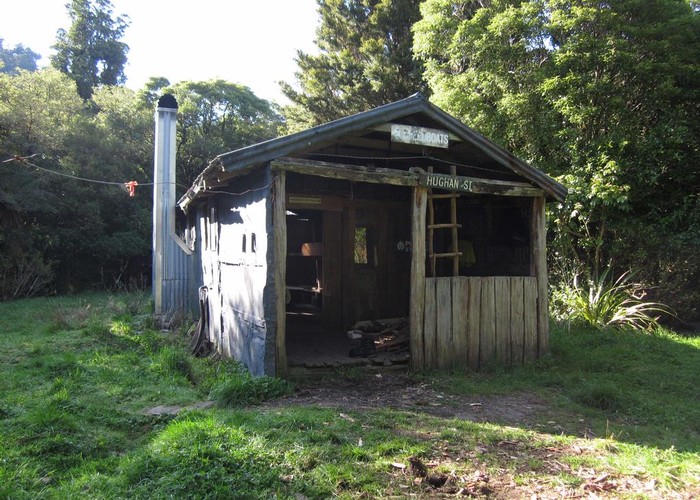
Sayer Hut was well worth the climb - dating from the days when huts were built by individuals, not government departments: when locally sourced materials, ingenuity, and rats were all that was required. The walls are hand-sawn timber slabs, the frame beech poles - even the bunks of hand-hewn timber. The only items carried in appear to be the roofing iron, also used to back the large open fireplace, and the random collection of windows which adorn the walls, some of local timber, some carried in, none matching.
I wake at 5am on Saturday to the sound of rain drumming on the iron roof. A beautuful comforting sound, that lulls me happily back to sleep. By 7am it's not so beautiful - it's warm in my sleeping bag, and clearly wet and unpleasent out there. Maybe I'll call the trip off and spend Saturday here. 'I'll give it till 8am to stop' - quite looking forward to lighting the fire, and spending the day here in the warm with the hut's stack of hunting and tramping magazines if it doesn't. 7.55am it stops raining. I unstick my nose from the sleeping bag and get up.
On to Mid Waiohine
===================
North of Sayer Hut, the last of the Waiohine River flats before the gorge have been ripped to pieces by pigs. Every plant, every tussock is uprooted - it looks like a cockey has been through with the plough. Kicking a sod, I see it's still green undereath - probably last night's work. Beyond the flats there's a 500m scramble over river rocks to reach the swingbridge opposite Totora Flats Hut. The rain's back, and it's slow, slippery progress. Plodding up the river shallows might be easier, but dry feet are a precious commodity. The strongly promoted Kaitoke-Holdsworth track crosses the river by the bridge and is virtually a motorway. A 2m wide swathe cut through the bush. It climbs straight and steady towards Mountain House. But is scoured deep in places by water, a series of small waterfalls through the bush: it makes better river than track. Those carefully preserved dry feet are soon a thing of the past.
I'd looked forward to seing the famous, rambling Mountain House. Built in the pre-war years with two segregated bunk rooms, and a common lounge, it was expanded repeatedly and erratically until it became famous for its size, exentricity and state of disrepair. However, I'm 10 years too late, and all that occupies the site is a 3-walled standard-issue DOC shelter.
If the track to Mountian House was a motorway, then the Holdsworth-Jumbo circuit which climbs to Powell Hut is an Autobahn. A well-gravelled track, cut into the hillside, each creek and hollow bridged and board-walked. It makes for a quick and easy climb to the bushline through unexciting mature beech forest. Powell Hut sits right where beech gives out to tussock, with views down over the Wairarapa and to the coast - or in today's case: cloud. The encouraging point is that it is, at least, looking down on most of the cloud. Thin, misty-looking stuff blows around above, the glow of sunlight strengthening and waning - giving the promise that it might break through. The bad news however, is that last night's rain has washed almost all of the snow away - the ranges have been a glorious white backdrop to Wellington all week - but now all that remains is a slushy mess.
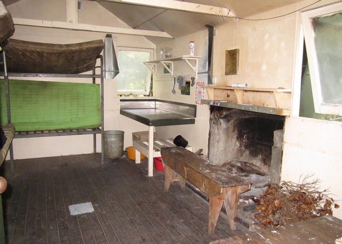
The sun never does quite break through, but the increased daylight is nice for the trudge over tussock, and later rock/lichen to the 1470m Mt Holdsworth summit. The narrow ridge to Isabelle is fun in the slushy snow: the ice-axe doing its job as walking-stick and anchor. The drop-off to mid-Waiohine is just as it looks on the map: one minute you're ambling down a gentle ridgeline, then at a cairn the track turns and drops near vertically through the cloud-forest towards the valley floor. Thankfully there's not much space between the trees so there's plenty of branches to hang on to, and plenty of moss to cushion the falls. It takes less than 20 mins to land at Mid Waiohine Flat: huge trees, a swingbridge, and a standard issue 6-bunk forestry hut complete with fireplace large enough to roast a whole deer on, and a thick coat of mould on everything. Seen it. Let's move on.
Getting back up the other side to to lighter and more welcoming Aokaparangi Biv, takes a little longer.
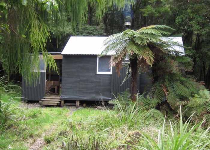
Aokaparangi is (almost) how alpine huts should be. A small 2-bunk insulated, double glazed hut nestling in a tussock basin on the bushline, 200m below Aokaparangi peak, with views out over the Waiohine Gorge below, and downriver to the Wairarapa. It's dusk, raining and there's snow on the ground. I've climbed over 2200m today: I'm shattered, cold, wet and very very happy to see the hut. All that's lacking is a fireplace, so I have a quick snow-wash, put the billy on, and crawl into my sleeping bag with a cup of sweet tea. Paradise. Later, with dinner cooking, I listen to the sounds of Radio Australia. There's even mobile phone reception with the phone in the bottom-left corner of the window, and I get to chat to Sim for the evening. I tell her tomorrow's an easier day - just 2 500m climbs over Cone and Sayers. I even believe it myself.
It doesn't take long to get to sleep.
An easier day
=============
Wake up to the sound of rain on the roof: vaguely familiar. Out the window, all the snow's gone. Washed away by the overnight rain.
The easy day starts with a 5km stroll along the main divide. Well - it starts with a 200m climb back to the divide: forgot that one. There's an icy wind whipping accross the ridgeline, snatching breath and freezing fingers. But the curve of the west coast past Levin and out towards Taranaki is visible, and patches of blue skies appear through the cloud. Heading south we drop off Aokaparangi, and climb another 100m to Wright. forgot that one too. Then off Wright and a steep scramble on all fours up the next unnamed peak, before dropping again to the bushline. And finally a 200m steady slog up Maungahuka to the hut. Forgot that, that, and that.
Mangahuka is a large hut, too large for its alpine location. It sits beside a small tarn on the main divide, sheltered only by a 10m high ridge, with serves to whip the wind into eddies and ensure it approaches from all directions, rather than providing any shelter. The tarn is frozen solid, and the verandah slippery with ice. Inside, the high cieling and absence of any heating makes for a cold night - has always put me off staying here, despite the picturesque location. I settle for soup and a coffee - warmth from inside, not out.
Cloud envelopes the peak as I eat. From Mangahuka I have to drop to the bush-clad Concertina Knob - an unfortunately the exact geography connecting Mangahuka and Concertina has disappeared into the mushy corner-fold in my map during the last 2 days of rain. There is a set of footprints heading east through the snow and mist towards where Concertina should be, but the 5-year-old image in my memory is of two ridges forking on the south side of Maungahuka Peak, both dropping steeply. The right-hand to the pinnacles: Te Iti and Te Nui, with ladders and wire-ropes spanning the cleft in between. The left, presumably, to Concertina. Memory proves correct and soon I'm dropping out of the cloud, shedding layers rapidly, to the saddle between Mangahuka and Concertina. Back in the dark, lush greens of the cloud-forest. Another 100m climb (forgot that one too) and I'm on Concertina summit, peering over the tree-tops to Neill's Forks 1000m below.
Neill's Forks hut was the first hut I ever visited in NZ. A trip with the Hutt Velley Tramping Club on a snowy, rainy winter's day. I recall that the club members were too tough to need a lighed fire, so we spent the night shivering in the damp as the mist from the adjacent rapids drifted down the huge expanse of the chimney. DOC have been at work since, and the fireplace and chimney have been blocked off and a wood-burner fitted. A 'brand new' porch also adorns the entrance to the hut - the iron rusting already after less than 5 years. Wishing you'd used galvanised? But despite the improvements, it's still a damp, cold spot. Mold coats the mattresses, with a body-shaped area where use has worn them clean. Windows are brown-green with lichen. Not a spot that encourages you to linger.
The climb to Cone feels more like 700m than 500m. A glance at the map explains why: it is. But 2 hours later I'm sitting back in the welcoming Sayer Hut boiling the billy for more coffee and soup. 4pm, and one more hill to go! I've been dreading this last climb all weekend, but the reality is much easier than the imagined tired slog on the last ounces of energy. The descent, on the other hand is worse: steep, slippery clay, and my backside is soon feeling like my nose felt on the way up!
I've been keeping a running sum in my head, and my easy day has included over 1900m of climbs. Feeling quite please with myself for still being upright, if not for my map-reading skills for not noticing them in advance.
6pm, and to my relief the van is still sitting on, rather than sunk in, the grass. I keep my dirty tramping clothes on until I'm off the paddock, just in case.
=======
A Mid Waiohine Circuit: 'easier day tommorrow ...'

Memories on a winter circuit to visit Mid Waiohine from the Mangaterere roadend.
Comments
-
 OldGoat Even my even toed ungulate cuzzys cant do 20m from bush edge to Mid Waio....!
11 October 2011
OldGoat Even my even toed ungulate cuzzys cant do 20m from bush edge to Mid Waio....!
11 October 2011 -
madpom OK. Few too many mistakes in that one to leave stand for posterity. Placenames corrected.
davidm: the secret to my rapid descent is bad knees - hurt like hell no matter what speed I take them at, so generally get them over and done with as fast as possible!
15 January 2011
-
 John Saunders Great description of the circuit. The big attraction for me is the way you avoid the vertical stuff while still getting into some pretty interesting back country. Another favourite, of similar difficulty, is Herepai, Dundas, Cattle Ridge, Roaring Stag. Might bump into you out there one day...
15 January 2011
John Saunders Great description of the circuit. The big attraction for me is the way you avoid the vertical stuff while still getting into some pretty interesting back country. Another favourite, of similar difficulty, is Herepai, Dundas, Cattle Ridge, Roaring Stag. Might bump into you out there one day...
15 January 2011 -
 davidm Less than 20 minutes down to Mid Waiohine???? From Jezebel?? Sorry, Isabelle?? It took me 2 hours the other day. What's your secret? Baked beans??
15 January 2011
davidm Less than 20 minutes down to Mid Waiohine???? From Jezebel?? Sorry, Isabelle?? It took me 2 hours the other day. What's your secret? Baked beans??
15 January 2011 -
bmackz Love your writing and you can be forgiven for calling it Colonial when its Concertina Knob since you had a hole in your map.
14 January 2011
ID 6285
About this article
62 views in the past year (5 per month).