Packhorse Hut Track
- 2 hr – 2 hr 30 min return by the same track
- Easy
- Bookings required
- Kaituna Valley to Packhorse Hut: 1 hour 10 minutes
A gentle climb to the historic "Sign of the Packhorse" hut beneath Mount Bradley on Banks Peninsula. Views of the Port Hills and the head of Lyttelton Harbour.
|
Walking time
|
0 – 2 days
2 hr – 2 hr 30 min
|
|---|---|
|
Distance
|
7.0km |
|
Type
|
Return by the same track
|
|
Grade
|
Easy |
|
Bookings
|
Bookings required
Required
A stay at Packhorse Hut requires booking.
|
|
Starts
|
Parkinsons Road, Kaituna Valley, off SH75 |
|---|---|
|
Maps
|
NZTopo50-BX24
|
|
Altitude
|
40m
–
450m
Altitude change 410m
|
|
Bookings
|
|---|
Access
This track crosses private land and is closed for lambing approximately August-October. Turn off the Christchurch - Akaroa Road (SH75) at Ataahua just over a small bridge into the Kaituna Valley. 4.5km along the Valley Road, just beyond St Kentigern's Church, you'll find the Kaituna Valley Scenic Reserve. This reserve is a 6 hectare pocket of remnant forest dominated by titoki trees. The acidic titoki leaves were unpalatable to browsing stock. The forest has been fenced off since 1957. There's a grassy picnic area here with toilet. A vague trail loops for about 15 minutes through the forest, which contains some large trees up to 100 years old.
After another 1.5km, Parkinson's Road leads off to the left. Park under the walnut trees where the road bends left. A stile here leads into the paddock.
The track
Follow poles to a vehicle track which sidles gently up the valley through regenerating scrub and forest. After around 25 minutes, the track crosses a little creek and climbs up an easy spur. The hillside affords good views back down the valley and out to Lake Ellesmere. In spring the vanilla/apricot perfume of native jasmine hangs in the air, while in summer the cicadas may be deafening.
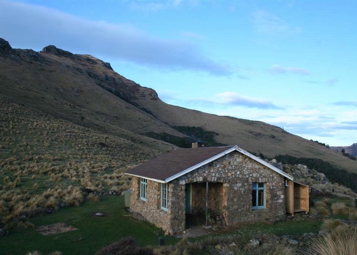
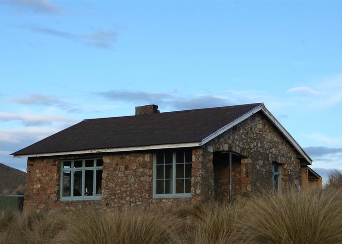
Nearing the saddle, the track passes through the Sign of the Packhorse Scenic Reserve, a fenced forest remnant. This remnant was donated by the runholder, Walter Parkinson, to the Crown early last century, and is still known locally as Parkinson's Bush. The handsome Sign of the Packhorse Hut is located on the saddle, with views into the head of Lyttelton Harbour as well as back down the valley. The hut was designed by the famous Christchurch architect, Samuel Hurst Seager, as one of the series of Summit Road rest houses along with the Sign of the Takahe, Sign of the Kiwi, and Sign of the Bellbird. The road from Gebbies Pass to Hilltop was surveyed but never built, leaving the Summit Road permanently divided into two graceful arcs, like an S with its centre removed.
Walking time:
Around the hut
A 10 minute walk west leads to the Remarkable Dykes. Follow the track that leads toward Gebbies Pass, sidling clockwise around Lyttelton Harbour. The dikes are a pair of prominent trachyte walls climbing above the track to the crater rim above. The best way to get a view from above is to return to the hut and follow the ridge -- attempting to climb the gully between the dikes is best described as misguided.
Another track leads eastward to explore the south face of Mount Bradley. This track continues on to Mount Herbert, although a short walk leads you into pleasant forest.