Ryde Falls
- 2 hr – 3 hr return by the same track
- Easy
Pleasant walk through beech forest to pretty falls.
|
Walking time
|
2 hr – 3 hr |
|---|---|
|
Distance
|
5.0km |
|
Type
|
Return by the same track
|
|
Grade
|
Easy |
|
Bookings
|
No bookings — open access
No — open access
|
|
Starts
|
View Hill car park, Wharfedale Track, west of Oxford. |
|---|---|
|
Maps
|
NZTopo50-BW22
|
|
Altitude
|
520m
–
600m
Altitude change 80m
|
The falls may be accessed from the Coopers Creek car park (at the end of Mountain Road, west of Oxford) or from the View Hill car park. The shorter route from View Hill is described here. The route starts off on the well known Wharfedale Track, and diverges after about 30 minutes.
Access
View Hill car park is a little hard to find. Reset your trip meter! From the centre of Oxford township, follow the main road (Depot Road) southwest out of town for 3km (ignore the first "View Hill" turn off to the right, just out of town). Turn right onto Woodstock Road and follow for about 10km. Turn right at the intersection with Ingrams Road (described as Perhams Road in other sources). A long dirt road continues from here, soon becoming a single lane. There are several branches to the road although all are clearly marked: follow the signs for the Wharfedale Track. There are also about four gates to open and close, and two fairly deep fords, which may become impassable after heavy rain. Winding along hillsides through patches of farmland and beech forest, the road finally reaches the car park after around 10km. This last section of road is actually marked "Wharfedale Track" on topomaps, which can be confusing. The car park is located roughly at the edge of the bare land marked on the map.
View Hill to Ryde Falls
Over a stile, the Wharfedale Track passes through light beech forest. The track was originally surveyed in 1879, and constructed as a road through to Lees Valley. The route was eventually abandoned in favour of the Ashley Gorge Road, but the remaining wide, easily graded track is popular with trampers.
After around 30 minutes, a track to Coopers Creek branches off to the right. Further on, a second track branches off to the right. Leave the Wharfedale here and follow this foot track. The forest is very pretty, dominated by beech, but scattered with rimu and other podocarps. Crown ferns carpet the forest floor, and yellow and red leaved horopito add colour.
The track winds gently down to the West Branch of Coopers Creek, passing another junction and path to Coopers Creek car park after another 30 minutes. From here, the falls are about 15 minutes away. The track drops quickly down to the creek, and crosses it to a small, pleasant campsite tucked amongst the trees at a confluence. There is a toilet located nearby. This campsite would be a nice spot to stop off at (and a rewarding side trip) on the Wharfedale Track, or an easy overnight trip.
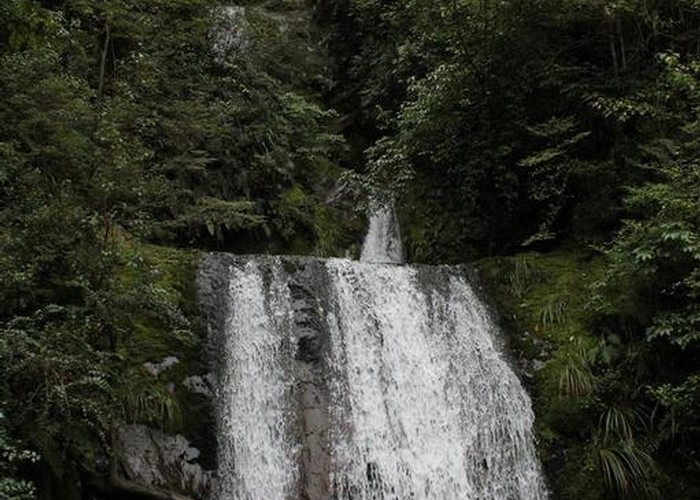
Beyond the campsite, the track continues into the trees on the true left of the left branch for a few minutes to the falls. The falls descend in three steps, all visible if you climb down into the creekbed. If you are more adventurous and willing to risk a broken head, the pool at the top of the last cascade is sublimely beautiful. The deep, round pool is ringed by slippery, mossy walls to form a rocky chamber. Above the pool, the two higher steps of the fall descend through a narrow crack, spraying mist into the air and catching vertical shafts of light. Water spills over the rounded lip of the chamber to finally splash into the creek below.
For an alternative route back to the campsite (if you don't mind a little swimming) follow the creek five minutes downstream to the confluence.