
Friday 20th March 2009
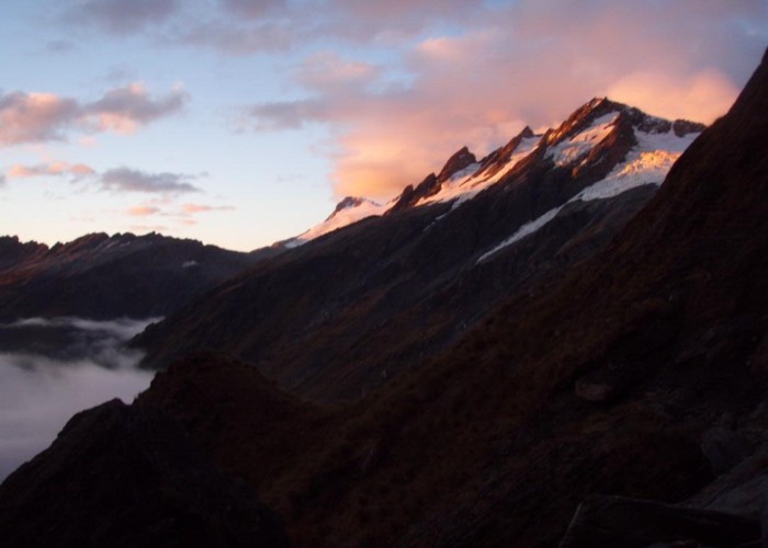
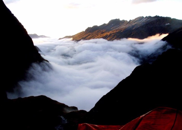
Friday dawns to wispy valley cloud, burning off already to sunshine and blue skies. The Fettes and Spur glaciers glinting in the morning sun as we break camp and make to continue our boulder-hopping up the Landsborough. The valley tightens again, and progress is impeded by house-sized boulders blocking the bank: the choices presented of swimming round their base or climbing the shingle slopes above. Shelter hollow presents difficulties: the stream still in flood, a roaring white torrent dropping through an endless series of waterfalls and rapids to the landsborough. Finally, 1km upstream, above the forks in the side-creek, reasonable flat crossings of both branches are encountered: but the entire detour takes time and energy. Going is clearly not easy in the upper Landsborough.
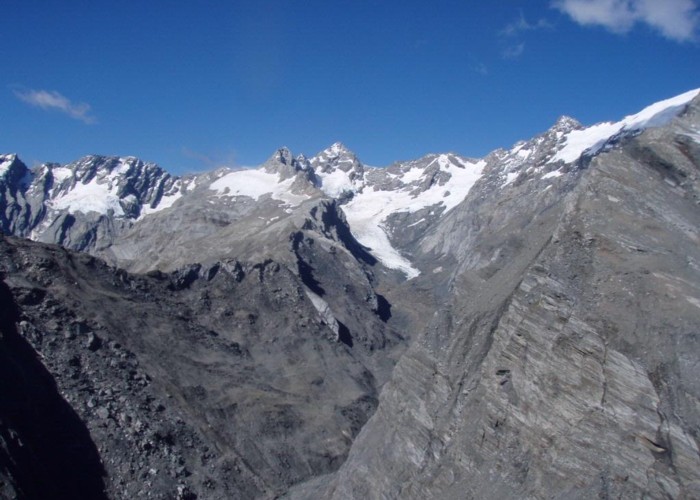
Another km upriver we reach The Sentinal. This obvious standing rock marks the end of the tangled, stunted beech forest and the start of the sub-alpine scrub. It also marks the first point in the Landsborough at which the river could be forded on this trip. The Townsend Glacier drops right to the moraine valley floor on the flats opposite, a rewarding sight after hours of rocky canyon. Confident now that I have the free choice of travel on either bank I push on up tussock slopes on the true left and find myself in the midst of acres of 3m high interwoven scrub: too strong to push through, too weak to walk across. The dog impatient ahead in the animal tunnels beneath the scrub: come on Boss, what’s the delay? We crawl from lone beech tree to lone beech tree and finally drop back to the river rocks where we should have remained. Lesson learned.
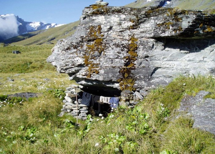
A further 2km of rock-hopping and the scrub gives way to tussock at the Rubicon. At last we’re free to enjoy the walk unconstrained. We celebrate by climbing the old lateral moraine above the creek to look for the rock biv marked on the map. Half an hour of searching later we’re none the wiser. Only one overhanging rock presents itself, but with a 45degree slope underneath. A little tricky to camp under. The climb is worthwhile though, giving a clear view up the Rubicon to
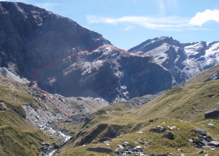
The moraine leads onto flat tussock river terraces, and to easy travel up the remains of the Landsborough to the Karangarua saddle. Sheer rock faces and hanging glaciers tower over the true right of the river: lowering upriver towards the saddle, but still just as sheer. The saddle itself is unbelievable at first: one of the reasons for my trip. On a map it is impossible: sheer bluffs 300m high from the river to the pass. Standing opposite 1km away this impression is confirmed. There is no way that could be climbed. But climbed it is: and not by rope and harness but on foot by trampers and hunters. The correct light, the sun shining low down the valley, reveals all. Starting at the head of a scree fan 1km downriver from the saddle, a narrow scree shelf runs up at an angle of 20-30 degrees, all the way from the base of the cliffs to the saddle. It looks precarious: narrow, rocky and with 300m bluffs below at its top end. Invisible without the sunlight to illuminate it, this is the route. Climbing the scree fan to the start of the platform, things become more obvious and more reassuring. The shelf is 10-20m wide throughout, though scree-covered and sloping away towards bluffs below. The kind of place to take good care. The kind of place to have an ice-axe or pole to self-arrest on the scree if required. But the kind of route that would be tackled without a second thought, if it weren’t for the knowledge of the drop below.
The view from the saddle is stunning. Above the pass, the Landsborough transforms from a river in a tussock basin to a post-glacial wasteland. Moraine litters to valley floor, the valleysides sheer and impenetrable. Not a plant in sight. Upriver, the point at which the black, rock-covered McKerrow glacier becomes the moraine floor of the valley is indiscernible. But higher up it is clear, blue and shining in the sun as it descends from its birthplace on Mt Isabel. The
The descent to the
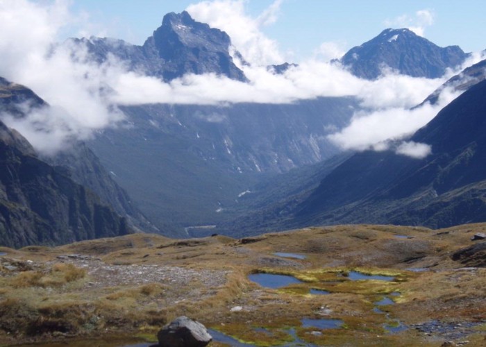
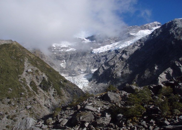
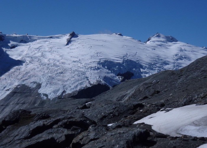
The next item on my itinery is the Douglas Neve. Not to climb onto or explore, but just to see. This huge expanse of ice dominates maps of the area and has to be seen. From the Karangarua Saddle this is hidden by the
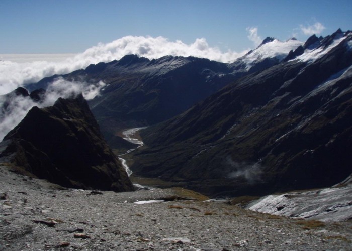
We follow the ridgeline east, heading towards The Gladiator to see if a descent to the
The best I can figure it, a slab of loose shale lies amongst the short tussock. As my weight goes forwards onto the leading foot, we take off: the shale and myself, sliding down the grassy slope on my back. I dig in feet and hands, but to no avail, the surface offers such low friction, there’s not much to be achieved. A brief glimpse of a previously unseen bluff below and I’m in mid-air. Plenty of time to think: ‘So this is it, Pom.’
Impact. Consciousness uninterrupted. Bloody hell – you got away with it Pom. The dog skulking nearby: the boss must be angry, he’s throwing himself off cliffs now.
POST: self check. What works, what doesn’t? Left ankle. Not good. Right wrist: not responding: a 1 inch arch where the straight wrist used to be. Worse. Blood on the rocks. Flowing. A red tide. The creek some meters below already swirling a misty red. Pumping. An artery? 10 mins max of consciousness, if so.
Priorities: Call rescue. Stop bleeding. Immobilise broken bones.
Pack has burst open on impact, stuff everywhere. Pulling things out, seeking survival kit at the bottom of my pack liner. Found. Light. Too light. No beacon. A desperate search of the remainder of the pack. Clothes, pockets, lining. Nothing.
Today is Friday. Panic date next Friday. 7 days to wait for rescue.
Priorities: Stop bleeding. Immobilise broken bones. Safety. Shelter. Warmth. Food.
My ‘nightrunner’ T-shirt easily to hand: a compress. Blood is coming from a gash on my leg: 1” deep, 1” wide, 4” long. Sliced right through the muscle. A hint of bone below. Sights only seen butchering deer. But this is me: my body, my blood, my muscle, my bone. A torquinette from strapping tape. T-shirt pressed into the wound. 10 minutes of worry, and the blood slows and stops. Not going to die here after all Pom. Not yet. I find another gash below the first, not visible for me, across the back of my leg and buttock. But deep – my finger goes in up to the knuckle.
Decide to forgo the immobilizing bones. Both are joints: so hard to splint. An here 400m above the bushline material for splints is a little short to hand. About 30m below a small grassy platform exists sheltered by an overhanging rock. 20 feet from the creek, protected from a south-westerly, though fully exposed to the more serious north-wester. But the best available.
Stock-take. The rocks are littered with stuff from my pack. The sleeping bag is in the creek below me. Soaked. Not good. Select what I know I’ll need – leave rope, possum trap, and other bits and pieces. Slide down to the creek on my (injured) behind and retrieve the sleeping bag. Now heavy with water.
Then proceed to crawl to the flat spot. Mainly through the creek as the sides are steep and slippery. Hands and knees not an option with a broken wrist: this is crawling on elbows and knees on sharp rock: more cuts and grazes to add to the catalog. Finally make it after 10 minutes or so of painfully slow progress. Pull out the bivvy tent: inner, poles, pegs. Ground is hard and rocky, but manage to bash in some pegs with a stone and my left hand. The remainder weighted down with rocks. Another crawled circuit of the tent, fly now on. Soaked sleeping bag stretched out on the rocks to dry. Orange survival bag weighed down next to it with rocks: a visible target for rescuers.
Into the tent, all my clothes on as keeping warm a priority before the adrenalin stops pumping. Come here little dog. You’ve been designated central heating today.
A plane buzzes over the
But I need to plan for seven days all the same. There’s 1.5kg of rice: 9 days worth if I was tramping, more lying here. About the same in porridge. 12 packs of soup. A dozen muesli bars. I’m not going to starve. Count out the dog biscuits: 30. a bit less than 4 days worth. The dog’s going to be doing it harder than me then. For me however, infection is the big fear. I lie there thinking: stories of other people in similar situations. Keep coming back to the HVTC tramper who spent 5 days awaiting rescue on the west coast with a compound fracture, only to succumb to gangrene infection and have the leg amputated upon rescue. Well losing a leg would be close up there with dying on my list of bad things that could happen. So I clearly need a plan to stop infection. A mental stock-take of my 1st aid kit draws a blank: my first aid kit is designed for minor injuries, or to get me through major ones whilst the chopper arrives. But it’s not to wait out a week with multiple major injuries. However, I do have a pot of salt, and that will have to do.
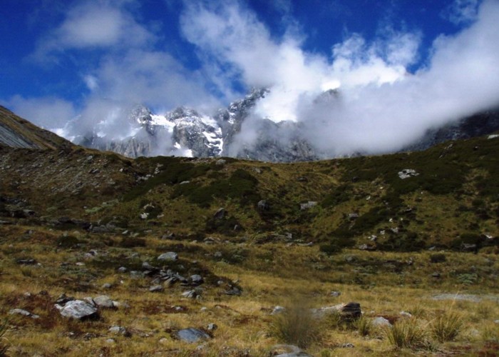
Looking out of the tent door, I have to say I’ve chosen a great spot to be laid up for a week. The Douglas Neve is no longer in view, but the snowcapped peaks of the
I doze. Two more planes punctuate the afternoon. Frantic waving, but no response. The planes small dots over the range opposite: how big would I be to them, even with survival blanket fully extended? More sleep. A full bladder breaks the evening. Too sore to crawl, unable to stand even if I did. The enamel mug gets dedicated as chamber pot for the duration! A good swirl and throw downhill the piece de resistance of the operation.
The sleeping bag is still soaked, so we curl up for a shivering night in clothes alone.