Thousand Acres Plateau
Kahurangi National Park
- 3 – 4 days return via same track
- Medium
- Day 1: Walk into Lake Matiri Hut (half day).
- Day 2: Climb onto the plateau, pass Poor Pete's Hut, and continue on to Larrikin Creek Hut.
- Day 3: Visit the Needle and Hundred Acres Plateau, and walk back to Poor Pete's Hut, where camping is pleasant.
- Day 4: Descend off the plateau down to Lake Matiri Hut and out.
- Directly west is the Mokihinui River running out to the coast;
- North is the distant Allen Range and Pike Peak, with the Wangapeka Track just beyond;
- northeast is a nearby unnamed peak (1565m) and the more distant Mount Patriarch (1692m);
- east is the large karst cap of Mount Owen (1875m);
- southeast is the Haystack and the journey back across 1000 Acres Plateau;
- south is the chasm of Larrikin Creek;
- and southwest is the narrow 100 Acres Plateau.
Explore a cliff-edged tussock plateau near Murchison.
|
Walking time
|
3 – 4 days
21 hr
|
|---|---|
|
Distance
|
39.0km |
|
Type
|
Return via same track
|
|
Grade
|
Medium |
|
Bookings
|
No bookings — open access
No — open access
|
|
Starts
|
Road end car park, Matiri West Bank Road, north of Murchison |
|---|---|
|
Maps
|
NZTopo50-BR23
|
|
Altitude
|
240m
–
1,438m
Altitude change 1,198m
|
The Thousand Acres Plateau is an ancient peneplain situated between the Mokihinui and Matiri Rivers near Murchison. The Late Cretaceous Peneplain formed 70 million years ago as the result of erosion of the land mass down to a sea-level plain. The plain was later raised, and remnants of it exist on the Heaphy Track, near Murchison, and in Central Otago. The Thousand Acres and nearby Hundred Acres Plateaux are rolling tussock landscapes dotted with sinkholes and crossed by limestone creeks.
Planning and access
It would be wise to allow a day to explore the area around Larrikin Creek Hut. It is possible to visit the 100 Acres Plateau as well as to climb both Needle and Haystack. DOC are focussing their resources on the Lake Matiri and Larrikin Creek Huts, while Poor Pete's is sliding into disrepair, and relies on the community to maintain it. A suggested itinerary is as follows:
From Murchison, take SH6 east, and turn left onto Matiri Valley Road where the highway crosses the Buller River. Follow the road alongside the Matiri River and watch for a turn, crossing the river to the true right. Continue on up to the car park. Some vehicles continue on up the road a little further.
Car park - Lake Matiri Hut, 2 hr
Follow a rough four-wheel drive track to a wide granite river fan, and cross the West Branch of the Matiri River here. This river can become uncrossable during rain. Remnants of an old hut lie in scrub on the north bank. The cableway nearby has been decommissioned, and cannot be used. A foot track continue on past old farm flats and into riverside beech forest.
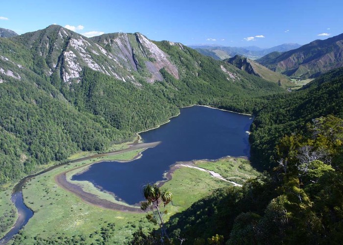
A gate marks the boundary of Matiri Forest, and the point where the track becomes distinctly more interesting (1 hr 15 min). The track sidles high above a bend in the river and passes a small lime-rich waterfall. The fall has formed a mossy balcony out of lime deposit, with some basic travertine terracing beginning to form. Some pretty beech forest and a gentle climb along a wide old track leads to the Lake Matiri Hut and a limited view over the lake itself.
Lake Matiri Hut - Poor Pete's Hut, 4 hr
Dropping down to the lake, the track crosses a shingle flat at the mouth of Bay Creek. At the forest edge on the opposite bank, two tracks continue onward. One heads upriver to McConchies Hut (this route leads north to the Wangapeka Saddle and Wangapeka Track). Our trail climb directly up the hillside, heading for the plateau, a climb of 750 metres.
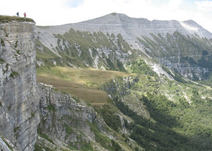
The track climbs steeply throught quintinia, neinei, toatoa, and rata, with sphagnum moss and Caladenia orchids often present on the floor. Later the track enters a low forest of bog pine, neinei, quintinia, and mingi mingi, and passes a view point (1.5 hr from hut). The view from here down to the lake and meandering river is magnificent. The track flattens off for a while before resuming a more gradual climb. It winds through large limestone blocks shortly before coming out onto the plateau (3 hr from hut).
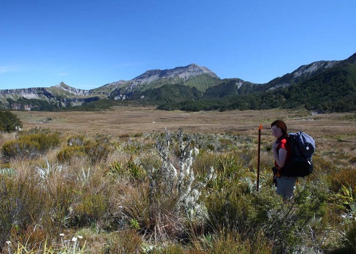
The plateau is wide and tussock-covered, with celmisia and flax distributed liberally, and pockets of beech forest scattered about. A poled route leads across to Poor Pete's Hut at the base of a small terrace. The hut itself is distinctly charmless, but a useful water supply (there is no tank, but a drum collects a limited amount of rainwater). Campers often set up behind the hut or down near the tarns marked on the map.
Poor Pete's Hut - Larrikin Creek Hut, 3 hr
The poles continue through light beech onto the terrace then on across the plateau, in the direction of the Haystack, with its striking banding of strata. The track passes several little limestone streams and a few tarns, gradually becoming muddier. Some of the streams are edged with a variety of flowers: Epilobium, Parahebe, Dolichoglottis, Celmisia, eyebright, Hebe, Wahlenbergia, and all of them drop off the bluffs to the west to drain into Larrikin Creek. Beyond one pretty creek, the muddy track drops through a forest of beech, cedar, and astelia, to pop out onto tussock near the hut.
The hut is situated at the forest edge where old stream alluvium has been colonised by Hebe, and right at the foot of Haystack.
Larrikin Creek Hut - Needle, 3 hr 15 min return
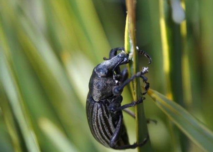
From the hut, a trail sets off through the hebe to a stream crossing marked by cairns. Look for the track heading into light forest on the opposite bank. Don't head up the stream as it becomes steep and dangerous. The scruffy track climbs quickly, edging past startling cliffs to a higher terrace. Cross tussock and look for a cairn marking the best gut to climb at the foot of Haystack. The track ascends the raw hillside then gets rather lost in tussocks and speargrass on the way to the saddle between Needle and Haystack (1 hr 15 min from hut). This area is rich in alpine plants, with large speargrass weevils feeding on the tips of leaves: when you disturb them they simply drop into the impenetrable network of leaves.
The saddle offers fresh views down into Haystack Creek. From here, a ridge trail leads toward Needle. This quickly becomes a hand-over-hand climb, but the top is reached in little time (1438m, 2 hr from hut), and the reward is 360 scenic degrees. Clockwise:
Options from here include dropping down the raw limestone ridge onto the 100 Acre Plateau then cutting back down to the track to the hut (watch for fossils in thhe limestone on the descent), or returning to the saddle and following the ridge to the summit of Haystack (1526m).