Mangamako - Casino Biv - Waihua
Te Urewera
- 2 – 3 days loop track with a road section
- Medium
The Ureweras by the Ikiwhenua Range near Galatea are good tramping country but rarely visited by trampers. The country is similar to the Whirinaki. The tracks are well marked and the huts well maintained. However the route starts and ends in plantation forest so can be difficult to find.
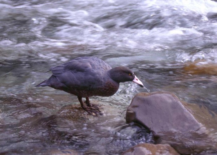
A feature of this area is the abundance of Blue Duck (Whio)
|
Walking time
|
2 – 3 days
12 hr – 16 hr
|
|---|---|
|
Distance
|
32.0km |
|
Type
|
Loop track with a road section
|
|
Grade
|
Medium |
|
Bookings
|
No bookings — open access
No — open access
|
|
Starts
|
Galatea Lookout Rd |
|---|---|
|
Ends
|
Waiohau |
|
Maps
|
NZTopo50-BF39
|
|
Altitude
|
100m
–
660m
Altitude change 560m
|
This trip starts from the locked gate at the bottom of Galatea Lookout Rd. Due to recent logging and road building here, it may now be possible to drive right to the National Park Boundary but I am not certain where you would go in to get there.
After getting to the top of Galatea Lookout Rd, turn right onto a good metalled road. After about a kilometer a small National Park sign (edit 5/19: the sign is gone) indicates a track to the left. Cross a clear felled area and you will find the start of the track into the Mangamako on the edge of the bush. It is marked by a large orange triangle but this isn’t visible until you are there.
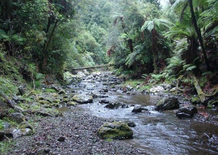
The good benched track drops steeply into the Karihoto Stream. Don’t make the mistake of mistaking this stream for the Mangamako (like we did) but carry on down stream for another 100m until you intersect the larger Mangamako Stream.
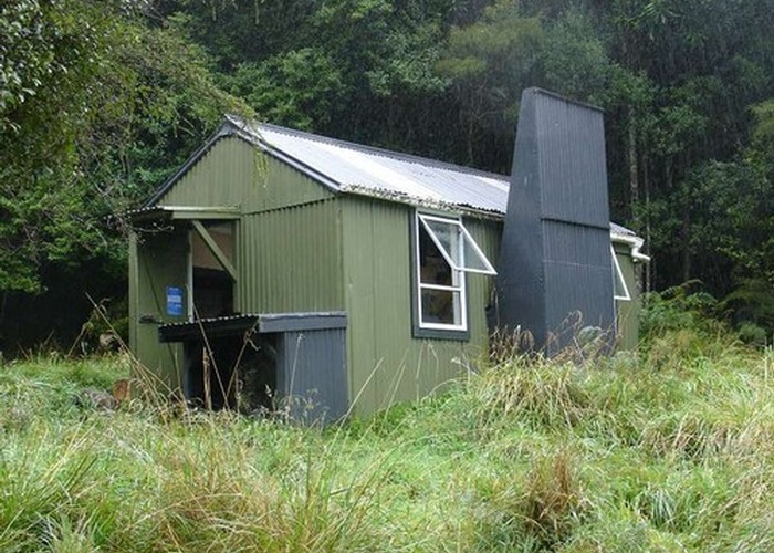
The travel up the stream is easy. There is occasionally a track or often isn’t but you just cross the stream as necessary. Take care to watch for the turn off to the Hut. It is not well marked and the hut is not visible from the river. It is a steep climb for 5-10 mins to get to Mangamako Hut.
From the hut a track leads from the door of the hut and traverses at an easier grade into the upper valley. Continue up the stream for about an hour until a large stream joins the main stream on the true right. A single orange triangle indicates that the way to go is up this stream. It is easily missed.
A couple of hundred meters up the stream a large orange triangle indicates where the track leaves the valley and climbs steeply onto the ridge and across to Casino Bivy, which you get to after about one and a half hours.
From Casino Bivy, a track leads down into the Onepu Stream and it is easy going down stream from there. As you get closer to the confluence with the Waihua the stream gets steeper and a bit rockier.
A large pool marks the junction with the Waihua. Watch for the endangered native Blue Duck (Whio). We saw a family of five in this pool.
A further kilometer downstream, watch for the turn off to the Waihua Hut on the true left. Once again it is above the stream and not visible from it.
The final section from the Waihua Hut involves going back down to the stream. Cross it and go up a small side stream on the true right marked by a white permolat.
About 100m up the stream a DOC stoat trap can be seen on the true left marked by a pink triangle. Climb to the trap and pick up a track that climbs briefly and then sidles above a small gorge before dropping back into the stream again. It then crosses the stream and climbs away from the valley on the true right.
The track climbs and follows ridges for a couple of hours before leaving the National Park and descending into Pine Forest. About 100m after you come into the Pines you will see and old weather beaten sign on the edge of an old forest road. Turn hard right here, almost doubling back and follow the overgrown road through a scrubby gully to the next ridge where you will pick up the proper forest road that you can easily follow to the main highway. It is about four hours from the Waihua Hut to the highway.
June 2009 Update
The contractors have begun logging along the road that leads from Waiohau to Waihua Hut. There were no barriers on the road when we went through but I suspect that this road will probably be closed to trampers for the next couple of years. (edit 5/19: the road is gated, but walking is fine) I think there is another track to Waihua Hut that goes along ridges to the north of the one described here but I don't know where that comes out.
On the plus side I believe that logging has finished in the Mangamako end of this trip and vehicle access has been restored right to the park boundary. (edit 5/19 - Galatea Lookout Road still gated right by the highway)
For the latest information I suggest talk to DOC in Murupara Ph 07-3661080