Raukumara East-West Traverse
Raukumara Forest Park
- 5 – 12 days one way
- Hard
An east-west traverse of either the Raukumara range, or the entire East Cape. A minimum of 5-8 days in it's shortest version (of which two are half days), but 9+ days for a complete traverse.
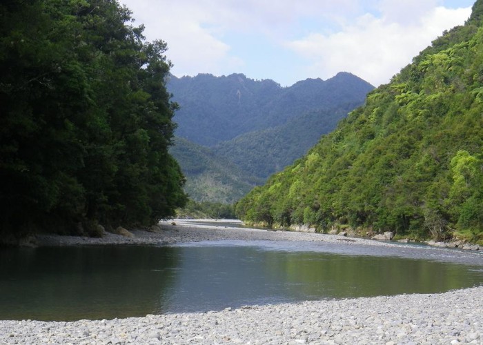
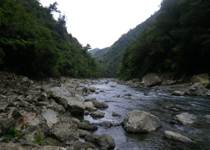
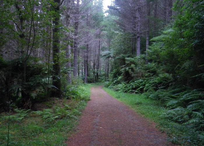
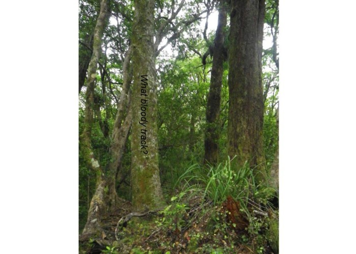
The main highlight of the trip is the Motu River - worth seeing in and of itself. The remainder of the trip provides an experience of the rugged, remote and poorly tracked Raukumara Range. This is 9+ days of broad gravel riverbeds, tight gorges, rough routes over scrubby saddles. It is not for the fainthearted or soft-footed. As I found out!
It can be walked on its own or joined with an Urutawa crossing to reach the Waioweka Gorge (SH2). I walked it as part of a North Island Main Range traverse from East Cape to Wellington.
For trips starting from the Raukokore / Te Kumi Station, see Day 3, te Kumi Station
For trips starting from the Mt Hikurangi roadend (Pakihiroa) see Day 5: Oronui Confluence
|
Walking time
|
5 – 12 days |
|---|---|
|
Distance
|
182.0km |
|
Type
|
One way
|
|
Grade
|
Hard
Scrubby unmarked routes. Good route-finding required.
Big / gorged rivers at each end, either and both of which can flood and trap you. Swimming was required in the Motu even in low flows.
Few facilities - self sufficiency required Grades explained
|
|
Bookings
|
No bookings — open access
No — open access
|
|
Starts
|
Either East Cape or Te Kumi Station (Raukokore access) or Pakihime Station (Oronui/Mt Hikurangi access) |
|---|---|
|
Ends
|
Toatoa (Motu Rd) |
|
Maps
|
NZTopo50-BE42
NZTopo50-BE43 NZTopo50-BE41 NZTopo50-BD43 NZTopo50-BD45 NZTopo50-BD44 |
|
Altitude
|
Sea level
–
1,118m
Altitude change 1,118m
|
(Still under revision - please be patient)...
All times are my times, carrying a full 14-day pack. including dogfood. As a rough guide, multiply by 1.5 to get the times that would be shown on DOC signposts - if there were any (there aren't).
East Cape
East Cape is not a simple place to reach. The nearest regular busses go to Gisborne / Opotiki. Cooks Couriers take passengers from Te Araroa to Gisborne each morning (early) and return in the early afternoon. That means you are pretty much obliged to spend the night in Te Araroa. For accommodation your choices are the campground (with cabins & takeaways) 6km out of town towards Hicks Bay, or backpackers nearer town. Despite rumours to the contrary in outdated guidebooks, there is no hotel or café, and the 4-square opens 10am to 4pm, weekdays. Approximately. Mostly.
From Te Araroa to East Cape is a further 16km, and your only choices are drive, walk or hitch. I’ve planned the trip a few times and hoped to hitch, but in the end managed to get a lift of the missus all the way to East Cape so avoided the logistical problems.
Day 1: East Cape to Te Araraoa, 16km, road / beach walk
East Cape Lighthouse.
500m, track, 144m climb
From 500m before the East Cape roadend a walking track climbs to the lighthouse. There are supposedly 700 steps (I lost count. Twice) but compared to what lies ahead it’s an easy walk. 10 mins each way. The lighthouse is not the eastern most point in the NI mainland – that lies on the beach below, accessible from 2km back up the road. However, it’s a great view, and a good symbolic point to start a North Island or Raukumara traverse.
East Cape to East Cape campground (Waipapa beach)
6km, 1.5hrs, road/beach walk
West from East Cape the road hugs the coast for 15km to Te Araroa, passing three headlands separated by 2 long beaches. At low tide, a beach-walk with short road sections round the bluffs. At high tide, road all the way.
The first beach, Waipapa, is gently sloped, broad, firm and good walking – intersected about 2/3 of the way along by a small stream.
The basic East Cape Campground lies in a paddock above – 100m from the beach. Looks out NE over the breakers to the uninterrupted ocean beyond. A small ablution block forms the only facilities – but it looks a lovely spot on a nice day. The creek cuts a small valley immediately the west of the camp, occasional stunted trees hiding in its shelter - limbs from which to suspend rope-swings over deep, still river pools.
East Cape Campground to Te Araroa township.
10km, 2.5 hrs, road / beach walk
Orotua Beach, 4km beyond Waipapa, is shorter and steeper. Waves undercut rough pasture at its head, though at low tide it may be walkable. Further west, spectacular white-stone bluffs abut the sea – the road in places cut into their base. A handful of creeks cascade in waterfalls, small alluvial flats at their base sandwiched between bluff and sea. Perilously located farmhouses tucked at the base of cliffs, sheltering from the elements but seemingly exposed to falls from above.
The coastal shelf widens, and we round the last of the headland to broad flats and the township of Te Araroa. There’s not a lot here – a four-square which opens around 10am, usually. A pair of self-service petrol & diesel pumps. 5 streets of white weatherboard housing, and the immaculate East Cape rugby grounds & anglers club. There’s a backpackers nearby, but the campground & takeaways are 6km west at the other end of the beach (1 river to cross just beyond Te Araroa if you walk along the beach, take the track inland just before the river at the far end of the beach to reach the campground).
Day 2: Te Araroa to Waikura Stream.
You could walk all the way by road to either the Hikuragi roadend – for Oronui Hut; or Te Kumi Station – for the Raukokore and Te Kumi Flats tent camp if you wanted. However, whilst it would avoid a tough bush-bash, it is a long 2-3 day road walk. So instead I joined the Kopuapounamu, Waikura, Roukokore and Huitatariki valleys together to give a off-road, on-crown-land route from Te Araroa to the Mt Hikurangi Roadend.
Te Araroa to Kopupounamu roadend
13km, roads
It’s still a 6km road-bash from Te Araroa to the Kopuapounamu River - SH35 South. From there head 7km up Kopuapounamu Rd to where the road forks, with the left fork heading for a station and the right into forestry. This is the easiest access to riverbed - further west farmland present in-between road / river.
Kopuapunamu roadend to Kopuapounamu headwaters
Riverbed walk, 3.5hrs
The best-looking route over to the Waikura is up the spur 2.5km due east of Taumaoteawhengaiao highpoint. That makes for an 11km riverbed walk up the Kopuapounamu to the base of the spur (opposite pt478). The route is entirely in Queen’s chain to the park boundary, and then Raukumara forest park beyond. The riverbed is broad and shingle as far as the park boundary. In places 4wd tracks exist on the south bank, but trees have been felled across many making the riverbed a faster option. Banks are a mixture of pines, native bush and post-forestry devastation. A private hut sits on the north bank a couple of km before the park boundary. Solid, but no beds.
Beyond the park boundary the gradient increases and the riverbed becomes more rocky. However it’s still good going all the way to the base of our selected spur. 3.5hrs
Kopuapounamu headwaters to Waikura River
Rough route, tough climb, 6hrs
The head of the valley is visible ahead – steep, sheer slips from ridgeline to valleyfloor, precarious knife-edges of bush separating each gash. The spur leaving the river 2.5km due east of Taumaoteawhengaiao offers a lower, gentler climb. This climbs NW to join the gently sloping EW ridgeline 100m SW of pt 853. This then heads west to the main watershed, hitting it at pt1118, 800m north of the Taumaoteawhengaiao summit.
There are good animal tracks on the spur – mainly goat, but cattle sign is present. However, supplejack is ubiquitous, hooking on pack and exhausting patience. The last section to pt 853 is very scrubby, but once on the main ridge things improve. Cattle clearly travel frequently along the ridge, and good broad cattle-tracks are present, if not exactly direct. We enter a series of interconnecting clearings – the main challenge being figuring out precisely how they do connect. The last 60m to pt 1118 is a tangled climb, but at least it’s all over. 3hrs

From the ridgeline we sidled west-north-west for a km-or-so – keeping below the scrubby ridgeline until on the main spur heading down between the 2 forks of the 1st sidecreek of the Waikura. Going was tough and slow – mature bush but tangled with supplejack. Once on the ridge we aimed downhill for the creek forks, but soon hit thick, almost impenetrable scrub. The best option was to find a slip and follow it to one of the creekbeds – we chose a slip leading to the southern creek, and hit it some 700m above the forks. From here going was steep with several small, and 1 large waterfalls to sidle round. Valleysides were steep but open grass/scree so sidling was possible but not exactly fun.
Below the forks, going was good for the remaining 700m to the Waikura. But then anything would have been an improvement. 3hrs
There is space for 1 small tent at the Waikura confluence, but good flats on terraces on the TR just above the park boundary, 1km downriver.
Day 3: Waikura Str to Te Kumi Flats Tent Camp
Waikura Str (park boundary) – Pakira Road/bridge.
5.5km, riverbed (LINZ). 1hr. Good going on river gravel.
Heading down the Waikura is easy, but uninteresting. The riverbed is LINZ-owned, but there is no Queen’s chain so the banks are private. The river flats are broad, and the river is soon lost in their expanse. On the park boundary hillsides of native transition abruptly to pines – later, to brown-dry hill country dotted with dirty-grey sheep – finally, green paddocks and cattle as we near Pakira Stn. Going is easy, but rounded river stones are hard on the feet. The road is impossible to miss, crossing the riverbed on an embankment with a short 2-span bridge in its centre.
Pakiri Station bridge to Te Kumi Station bridge. Te Kumi Rd, gravel road. 6km. 1hr30. Flat road.
Easy going along a public, metaled road between the two bridges over the Waikura. Access down the Waikura is from either side of the bridge at Te Kumi, though the 4wd track starts on the far (southern) side.
Te Kumi Station to Te Kumi Flats.
Riverbed route via Waikura and Raukokore. 12km - 4hr30.
Good/average going. Many crossings of Raukokore. Knee to thigh in low flows. Mainly river stones, small boulder on rapids.
The route follows the broad river flats downstream. A 4WD track winds down the riverbed, cutting out onto grassy terraces on the southern bank after the first short gorge.
The Raukokore is broad: shingle flats at the confluence, and for the 1st kilometer upstream to where a wide shingle fan sweeps down from the ranges to the south. Beyond, the Raukokore narrows, emerging from a tight bush-clad gorge to the west. Thigh-deep crossings follow, heading upriver on an easy gravel bed which broadens beyond. Soon, the gravel turns to boulders and the gradient increases. Going slows for a couple of kilometers, clambering over river boulders as we pass the first main rapids. Planning the trip, I’d been advised by hunters who hunt this area on horseback – I’d love to see how horses navigate that bit!
As suddenly as they started, the rapids end – a plain of gravel lapping against the tops of the last boulders.
It’s 9km on the map from the Waikura to Te Kumi, but on the ground feels much further - the river twisting between spurs. One deep pool spans the entire flow – bluffs on either side, water waist deep, but otherwise crossings are knee to thigh deep – easy enough in normal flows.
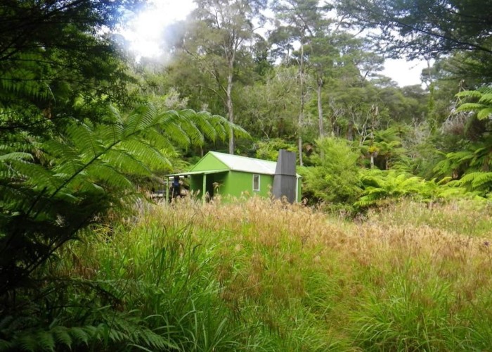
Finally, the slope of the valleysides softens - sheer walls, trees clinging unfathomably to rock faces become gentle, wooded slopes. Peaks lower towards the river. A few more bends follow before finally emerging at Te Kumi Flats. Te Kumi is covered in low bush and fern forest. As you near the gorge at the southern end of the flats, a clear track leads 20m east from the river bank into open punga bush where a tall blue-tarp-roofed shelter looks out towards the river – Te Kumi tent camp (Te Kimu Biv)
Te Kumi Tent Camp / biv consists of a tarp-on-timer-frame kitchen and a separate family tent as a bunkroom. The forest floor around has also been cleared allowing for many additional tents to be pitched. A large stone-built fireplace dominates the open western wall of the kitchen – a solid frame holding an iron bar for pots above it. A bench has been cut into the slope round 2 sides, and the third has a long table. Numerous pots, pans and reading material are stores in secure storage boxes beneath. A couple of camp chairs are the final luxury. A great, spacious, weatherproof shelter, looking out over the river.
Day 4: Te Kumi Flats Tent Camp to Huitatariki Stream, 7hrs,
Tough route on riverbeds & over 2 saddles
Te Kumi flat to Okapua/Raukokore confluence (former Green Hut site)
1hr, 3.5km, riverbed route, moderate.
Going remains reasonable up the Raukokore above Te Kumi Flat. A few deep pools require wading, but nothing serious. Green Hut, just beyond the confluence with the Okapua, is long gone – a few wires remaining, but no hut.
Okapua/Raukokore confluence to Huitatariki Stream headwaters,
9km, 5hrs, riverbed / bush route. Scrubby / hard in places
The route starts with easy up the Okapue as far as the 1st forks. A narrow stream but with an open bed of river stones. Beyond, the valley becomes increasingly gorged; waterfalls become more common. A final long gorge section between 2nd and last forks requires sidling on south face – the gorge itself is less than 2m wide. We take the southern branch at the last forks shown on the map, to climb to the saddle west of Ranganuiatoi. The climb up the rapidly dropping stream is steep with windfall & vines in the creek, but not too bad. From the forks where the map shows the waterway ending (it doesn’t end here) we climb sue south to reach the saddle between Ranganuiatoi and pt814. The climb, and the saddle itself are good going in open, mature bush.
From the saddle it is necessary to sidle round Te Ranganuiatoi, above the headwaters of the Raukokore to reach another saddle dropping into the Huitatariki. We sidled level with the saddle, and confirm that a route at this level is steep, choked with windfall, and not fun. Maybe climbing the peak or dropping to the creek would be an improvement. We climb to the unnamed / unnumbered peak on the ridgeline 1km WSW of Ranganuiatoi using the spur due west of it. This spur was good going in good open bush, as was the main ridgeline at the saddle.
From the unnamed/unnumbered peak, we then dropped SW down the vague ridge shown on topomaps hitting the creek 100m above its first forks. This descent starts good, but gets increasingly steep, scrubby and full of supplejack. The last 200m to creek very steep & tangled. Dropping to the creek too soon leaves you in waterfalls & an impassible gully, so persevering with the ridgeline is the only option.
Going improves once in valley floor. There is still a lot of vine around but gets gradually less & riverbed opens up. The 1st good camp spots are on the park boundary where good grass flats on true right are reasonable for a camp, but would flood in heavy rain. For true bad weather spots you’d have to continue into the pines & find flat spots on forested terraces.
===
Day 5 Huitatariki headwaters to Oronui Hut
Huitatariki headwaters to Oronuiu confluence
Riverbed route: 8km. 2.5hrs
To park boundary – 1hr. 1st km from headwaters is tight and scrubby – a fair amount of windfall across the river and tangled banks. However, the valley widens and going improves for the next km to the park boundary at the ford, where the 1st flats are encountered and some small camping spots exist (better flats are present 1km downstream, though on private forestry land).
To confluence: 1.5hrs. From the park boundary the valley becomes wide with grassy and forested flats and a broad shingle riverbed. Going is fast for 3km-or-so, before the valley again closes in much sooner than the map suggests. The gradient becomes steeped and the riverbed boulders rather than gravel. It’s a case of boulder-hopping until you reach the Oronui confluence.
Oronui Confluence to Oronui Hut.
2.5hrs, riverbed route. Moderate.
The Huitatariki / Oronui confluence is 5km upriver from the Hikurangi roadend, so if you’re coming from there you’ll have an additional 1.5-2 hrs of walking up what appear to be broad shingle flats to reach the confluence.
From the confluence upriver we start on deceptively broad shingle flats. However, the valley soon narrows to become pools, boulders and bluffs. Crossings are necessary in pools mid-rapid and some are challenging even in low flows. Sidle options may be available on the TR but would require a lot of climbing. Above the park boundary the valley widens again and it’s good going on shingle flats as far as the Mangarata / Oronui confluence. From here the Oronui enters a 6km long gorge which looks tight, winding & challenging on the map. However, the river has lost much of it’s flow at the forks, and it’s rarely over my knees, and easy going on a gravel riverbed even when in the water. The 1s 2km from the Huitatariki were definitely the worst, though thus gorge could be bad enws after heavy rain as there are no sidle alternatives available – easy to get stuck at Oronui Hut.
Oronui hut is located just where the gorge finishes. The river forks, with shingle beds leading north, west and south. Oronui hut is on a terrace 30m above the river between the sth and west fork. Quite a steep, cruel climb for the end of the day, but a good thing considering how many valley-floor huts have been swept away in the Raukumaras. Thankfully there’s tank water so trips back to the river are not required.
====
Day 6: Oronui Hut to Te Kahika Hut site ‘lost hut tours’
Oronui Hut to former Mangatutara Hut site.
5hrs. River & ridgeline routes. Medium.
From Oronui Hut we drop back to the river & head up the Mangamauku (south fork at the hut) for 3km. The riverbed is the usual Raukumara mixture of good shingle flats with narrow, slimy rocky sections, sections of windfall across the river. But ok. 45 mins.
Reaching the forks where the track over to the Mangatutara starts, there’s absolutely no sign of a track. Just thick, uninterrupted bush with scrubby undergrowth. Poking around the rising spur that should contain the track is fairly obvious, & heading up that blindly is the best plan. Occasional permolat markers appear and eventually a reasonable ground trail establishes itself. Sections of windfall obliterate the track, and markers are infrequent, but with a good nose it’s followable.
Carved trees mark the summit clearly – possums & people alike carving their mark, but here the track & markers pretty much stop. Selecting the ridgeline south (not being deceived by animal trails heading NW) it’s a case of compass bearings & trying to keep near the scrubby, impassible ridgeline, whilst looking out for the ridge splitting west towards the Mangatutara. The best going is just west of the ridgeline. After 1km the ridge west is fairly obvious, and occasional track markers give some reassurance. I lost the markers around pt790 where they appear to head north, dropping 1 spur upriver of that shown on the maps. I follow the spur where the track is shown on the map, and can confirm that it is steep, scrubby, tangled and has never contained a track. We pretty much fall / slide the last 100m to the valley floor. 2hrs river to river
The Mangatutara is reasonable going as far as the hut site. Broad, gravel flats, some grassy. Occasional gorges, but nothing tricky – just wading & wet feet. The shingle flats are generally much wider than shown on the maps, and by the time you reach the Mangatutara Hut site, they cover the entire valley floor, including the site of the former hut. There’s no great camping spots here, except on river shingle. Could be done, but you’d have a lumpy, uncomfortable night. However, fire rings show it does get used. 2hrs from base of descent to hut site.
===
Mangatutara Hut site to Te Kahika Hut site.
Riverbed & saddle. Tangled & slow in places. 4hrs
There’s a final 2km of good going down the Mangatutara from the hut site before you turn up the side creek downstream of pt 422 to start the crossing to the Waihunga. The creek is easily identifiable by the sharp dogs-leg at it’s mouth, and is the 1st after the flats end.
The valley is tight, scrubby – choked with lawyer and windfall. The only space clear of vegetation is in the water in the narrow creek-bed, and it’s the worst going so far of the official crossing route. There are also a few forks not shown on the map, but keeping track of how far you’ve gone, combined with good compass work should see you right. In summary: right at the 1st major fork (shown on map). Right at the next fork (not shown on map). The valley becomes steep, but the vegetation opens and the banks become sidleable at last. Then left at the next fork (final one shown on map), left, right at 2 more forks not shown. Finally the remaining trickle of a stream swings to the south, and it’s time to climb the track to the saddle. Only, predictably, there is no track. Just a compass bearing through the punga-bush, though I did spot one single piece of permolat in thick scrub at one point. Another compass bearing down the far side. Bluffs run beside the main stream when you reach it, and careful scouting is required to find a side-stream dropping gently enough through them to reach the riverbed safely. 1.5hrs hut site to headwaters
Thankfully, beyond here, things start to improve. The 1st 1.5km has a good broad valley floor with deer-trails through the bush. Then follows a tight gorged section, walking in the riverbed to the 1st major sidecreek, soon after which the valley widens again. Shingle flats appear, often covered by brittle, scratchy scrub of buddleia & other unidentified, but probably invasive species – not great, but walkable. Travel alternates between scrubby flats and shingle riverbed all the way to the Te Kahika confluence. Te Kahika Stream is smaller than the Waihunga and easily crossed in normal flows. 2 more crossing follow before the flats and the former Te Kahika hut site. 3hrs headwaters to hut site.
River channels cover the area where the hut once stood, but reasonable spots for camping can be found on the river banks. All look like they would flood in really heavy rain though.
Day 7: Te Kahika to Mangakirikiri Hut.7km, 3.5hrs
Te Kahika Hut site to the Motu via the Big Unknown.
Riverbed route / route / track. 2hrs
This saddle route in not shown on maps, but is the best maintained bit of the whole crossing. The normal route heads up The Big Unknown stream for 1.5km, then crosses the saddle to the west to hit the Motu at the sharp corner & flats 1km above Sanny’s Rapids. This cuts out 4km of tough gorges & rapids in the section of the Motu immediately above Te Kahika.
From the end of the Te Kahika Flats, it’s another 1km downriver to the confluence with The Great Unknown. The river mouth is a tight gorge, wading the only option, but the valley opens up a little beyond, and travel on narrow stony banks becomes possible: 30% wading, 70% shingle banks. A shingle fan drops on the east, and we look out for the 1st stream on the west after it. The stream is small, narrow & scrubby – as usual. The route heads up the gully between the 2 forks, nearer the north one than the south – but we manage to miss the forks entirely – they are not obvious, and end up several hundred meters up the south branch, before cutting north across the face. We head up on a compass bearing towards the saddle through tall toetoe – great fun in the rain. At some point a DOC track cuts across this basin – we spot one triangle but can’t find the next -and cuts into the bush on the north side. We missed the tracks and a lot of bush bashing & compass work followed.. But once on the track, in the bush, it’s well cut, well marked all the way to the saddle. Where it stops.
Descending the far side of the pass is fairly obvious, and the usual mixture of bush, supplejack & fern. Simply head down the initially dry velley until you find the stream, and follow it all the way to the Motu. It hardly warrants description: the usual mix of windfall, supplejack, slimy riverbed stones & waterfalls to be scrambled / sidled. The creek emerges right on the corner of the Motu, where the sedate river enters rocks and rapids as it swings south. A good, well used camp spot is tucked just inside the mouth of the sidestream, complete with tarp & chair. A handy spot to wait for the Motu to drop …
Motu-Great Unknown track to Mangakirikiri Hut,
river route, 4.5km, 19 river crossings. Big river. 2hrs
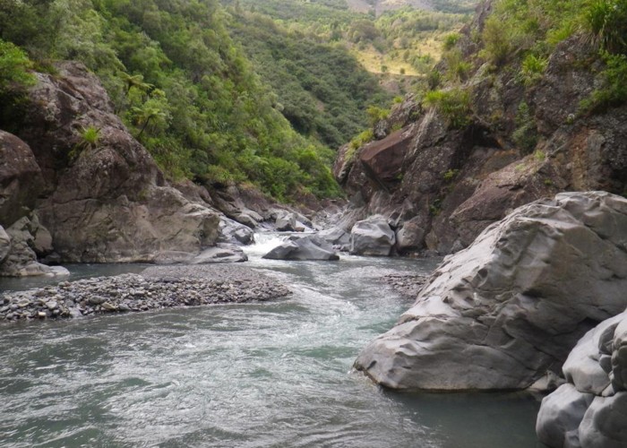
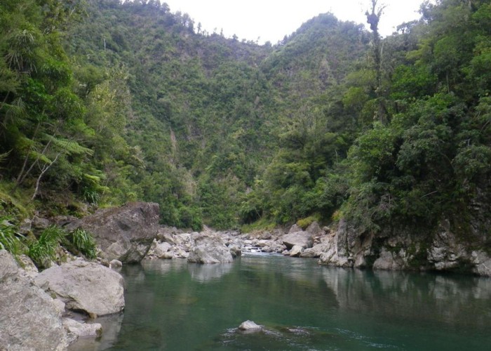
The Moto is unlike other Raukumara rivers. Deep, placid, flowing in a defined single channel between its bank. Absert are the gravel flats and braided channels of the other Raukumara valleys. The valley sides are high and sheer and offer little hope of sidle routes if the river is up. The scenery is both serene and spectacular. It feals like a remote and wonderful place. By far, the highlight of the trip. When not in flood. On a previous trip I only got within 4km of it, and was already deafened by the roar of muddy brown churning water, carrying entire trees, rolling boulders down river.
A long straight lies immediately above the confluence, with good travel on either bank. Beyond lies the first gorge- 1.5km of frequent crossings from gravel-beach to gravel-beach – each crossing upstream against the flow for those heading east-west. Crossings are thigh deep in low flows, and would be deeper after rain. 10 crossings all up to reach the end of the gorge.
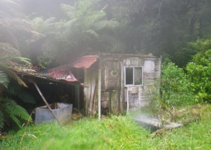
A km or so above the gorge, a dilapidated prefabricated cabin sits on the south bank, a clear track leads to it from the river. No beds, and one wall gone, but shelter if stuck.
The next gorge is not as severe, but 7 more crossings follow before reaching the Mangakirikiri stream confluence – the last being the deepest and requiring a swim when we were there. The confluence is obvious with the Motu swinging sharply south and the much smaller Mangakirikiri stream continuing straight on west.
To reach the hut we head up the Mangakirikiri for 200m or so before finding triangles on the south bank marking the start of the track to the hut. It’s a steep climb to the plateau then 200m or so along the escarpment to reach the hut. A large empty clearing just before the hut may arouse some concern – but fear not, the hut is still there – in the next clearing.
Mangakirikiri Hut is a standard 6-bunk NZFS hut (SF70?) with open fire place and tank water. Sadly, it does not look down over the Motu, but you’ll have to make do with views of the valleyside opposite. A separate smaller hut with corrugated iron walls and no floor acts as woodshed. The hut gets a couple of pages-worth of visitors per year – mainly rafters heading down the Motu, and a few hunters- many doing both. One or two parties a year seem to attempt the east-west crossing. People accessing on foot are split fairly evenly between those who head down the Motu from Otipo Rd and those who drop into Mangamate/Mangakirikiri Stream.
Day 8: Mangakirikiri Hut to Whitikau Campsite (via Mangakirikiri / Mangamate)
There are 2 routes from Mangakirikiri Hut to Whitikau Campsite, either up the Motu and along Opiti Rd, or up the Mangakirikiri/Mangamate and along Pukeiahonoa Rd / Takaputahi Rd. Both involve a lot of time in the water – the Mangakirikiri is smaller, but no shallower.
Here we take the latter route. Note that Opiti Hut is no longer there if you go that way.
Beyond the Motu the nature of the valleys changed. Gone are shingle flats and scrub/windfall choked streams. Instead we get green moss-covered gorges, deep rivers and pools. The only thing the same is it is wet, slow going!
It’s about 4km up the Mangakirikiri to the Mangamate confluence. Gradient is flat – no falls – but pools are deep, and the valley gorged in places. Several pools require swimming. However, there are also narrow flats, and some spots where you get out of the water into the bush. 1.5 hrs
The Managmate is a different story. Narrower, just as deep, but steeper. Small falls are frequent, with deep pools at their base, and with sheer bluffs on either side require negotiating in the river flow. For much of the early section the entire valley is 2 to 4 meters wide, and entirely taken up by the river. Logjams also become frequent and require more scrambling – the reward being the easy going over the accumulated gravel flat above each. After a couple of km of gorge, the valley opens again and going gets easier. Taking the NE fork at each confluence. Flagging tape marks a route to the trig at pt707 up the prominent ridge, but that’s a long-way round to the road. Instead we take the ridge between the last 2 forks draining from the road. This has a good, well travelled route up it, and is occasionally marked with tape. 80m below the summit, it emerges only an old logging track, which we follow SW, circling round to join the N-S Pukeiahomnga Road where it swings west round the summit of the last peak before the valley head. 1.5hrs
The Pukeiahomnga Road gets occasional ATV use from local hunters & possumers, but is not wide enough for 4WD. It’s easy, but long going meandering south along the ridgeline though regenerating bush before finally dropping into pines and down to Rawera Stream. Occasional clearings give views back to Hikurangi – now a satisfyingly long way away – and north towards the coast. Just before the road swings west, a tarp camp is tucked on a saddle – but no obvious water source exists. 2hrs to junction.
From the Takaputaki Road / Pukeiahomnga Road junction you can either head NW to the Motu Road saddle above Opotiki, or south to reach it at Toatoa via the Whitikau campsite. Given we were heading on to Pakiki, we head south.
This is a legal road, though signs and a padlock at the south end suggest that permission is required. It’s easy going for 4.5km through the pines to farmland at Rawea, and then another 8km on a formed public gravel road to Whitikau. There are a few houses & baches scattered along this section. 3.5hrs
Whitikau campsite is at the junction of Opiti Rd and Takaputaki Road. There’s a couple of clearings sheletered by large conifers, and a long-drop. A short track drops 20m to the Takaputaki River, where there is water (obviously) and pools for a swim. This is a basic DOC campsite, and this is free.
Day 9: Whitikau Campsite to Motu Rd.
It’s a further 12km west along the Takaputaki Road to reach the Motu Road at Toatoa. Here there’s a shelter for cyclists, and occasional traffic. I got lifts quite easily on earlier visits, though there’s only a car every hour or two. Cycle shuttles busses may also collect you here (or at Whitikau?) by arrangement.