
The Bryant Range behind Nelson is part of the Mineral Belt: a dry landscape of butterscotch hills and toxic soils. Two rock species, rodingite and dunite, have their type localities here. My route leads up the Roding River to Rocks Hut, onward to Dun Mountain and on-track back down to Nelson.
The road up the Aniseed Valley is long, narrow, and winding. It ends at the Roding Waterworks Reserve, where a new carpark sits on the meadowy goldenbanks of the Roding River. Information boards describe the history of the catchment. Several copper mines are located upstream, none of which were a great success. A tousled footbridge is littered with debris from past floods. Over the river are a couple of old buildings and the caretaker's cottage, where walkers are asked to check in. A tidy garden of rosebushes and ornamentals. I bang on the door a couple times but no one comes.
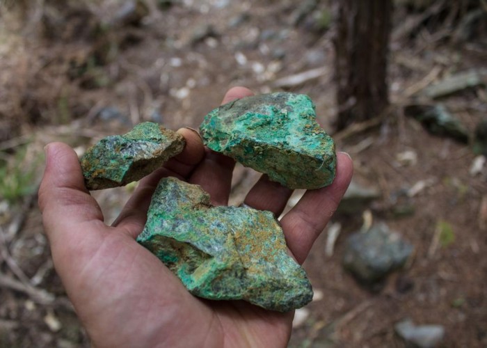
A vehicle track heads up the valley, and I follow it, climbing quickly to the Roding Dam. A pipe leading under the Barnicoat Range supplies the city's drinking water. I poke around something that looked like it might be rodingite, but not knowing what to look for, I give up. The track continues easily up valley, crossing the river a few times and bending onto United Creek, past a turn-off to the Champion Mine, and up to the United Mine smelter site. Not much here: remains of a chimney and smelter, a scattering of iron parts, a pile of slag. A picnic table arrayed with assorted rocks, blue- and green-bloomed indicating copper. There were two separate mining operations here, and what remains come from the second effort. Kanuka scrub fills in the once-stripped hillside. Another route to Champion Mine heads off into the scrub.
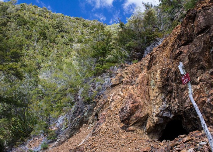
Over to the true left, the old United Mine tramway leads gently upcreek and soon runs out. Across the creek, a dry hallf-hour track scrambles through the kanuka and gorse scrub up to the mines themselves. An orange tumble of rock marks each level, the adits misshapen, humble tunnels into the hillside. Copper-stained rocks are scattered around.
The track ends here. Back on United Creek I wander up the riverbed, struck by the handsomeness of the area. The ultramafic soils drive out trees and leave a pretty scrubland. The land has bonded and hard-crusted, and a series of little streams drop into the creek as showers from overhangs. Sadly, the creek is choking with Didymo ooze, a nasty sludge that has no place here. I pick my way up the creek past deep pools and colourful rocks. At one point, a cairn on the true right indicates a fresh-cut track across a bend in the creek. Perhaps some local's weekend project, the track runs out in manuka and flax halfway across the small bend, so I push on through and return to the creekbed.
A prominent orange hillside ends the valley where United and Jackson Creeks fork from each other, right and left. A cairn is here. I turn right, up United Creek. It is clean of Didymo, and full of boulders. The walls close in as steep shingle banks, and I come upon a series of waterfalls and tangles of rock and timber. A possum floats drowned at the foot of a waterfall. Where the creek enters forest, rata stamens light up cracks in the rocks in thick red drifts. I feel uneasy about this route. I get the feeling no one comes this way.
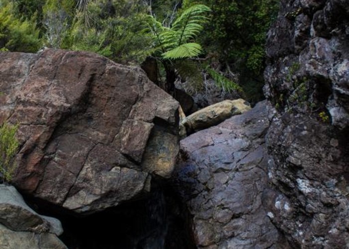
I come upon a waterfall over a slab of rock that must be six metres. I find a point to climb out of the gorge. I push into the beech forest and climb alongside the creek. A few rusting metal cans here indicate that somebody was here once. The forest is slow going. Through turpentine scrub, I push back to the creekbed. Neither option is better than the other. I need to get out of this creek. I come upon an long slip on the true right bank, and I climb the orange scree to a small outcrop of rock. This comes away in my hands to reveal a colony of tiny red ants living in the cracks. I look at the map to pick out some landmarks. A series of undifferentiated forest knobs mark the valley, but eventually I figure I am near the Monster Mine site. I decide to keep my elevation, and sidle northward. The travel is relatively easy, over untracked scrub and rocks. I have good views up the valley and I am glad to be out of the choking head of the creek.
Soon enough, I can see a clear saddle leading over to Rocks Hut, just a kilometre away. North, I can see the track around Coppermine Saddle and Windy Point, with Dun Mountain, prominently orange. The saddle is thick with kanuka saplings. I get down amongst these and worm through them, rigid poles just hands-widths apart, blocking views in all directions. Several Powelliphanta snail shells lie cracked open on the ground. Travel is slow with no encouraging signs in any direction. I feel claustrophobic. Occasional rock islands lift above the scrub. I try to pick the best route, but perhaps there is no good one. Eventually I come out on the far side of it all, and look right across the Pelorus River to the Richmond Range. I can see the hut. It is an easy drop through patchy beech forest. Too easy and I think I have walked right across the track I'm looking for. I sidle on a contour through the knotted undergrowth to where I feel the hut should be. A track comes from somewhere, and an easy stroll leads to the hut. A group of retirees are here. They have met up for their annual trip. They laugh at the generous size of my dinner, a spicy Indian curry on noodles. It is also breakfast.
Next morning, I head out from Rocks on the easy trail into fog and gloom. At Dun Saddle, I drop my pack and climb up Dun Mountain. The sun burns through the cloud, and my shadow casts a spectre of the brocken on the swirl below. I head on up to the shelter and the snowgrass summit and come on back, seeing the retirees moving purposefully across the saddle beneath me.
The track enters the Waterworks Reserve (to the right is the Maitai catchment and to the left the Roding) and drops to Coppermine Saddle which is littered with pieces of black and green serpentine rock. The mines were sold on the promise of copper, but only chromite was found here.
In 1975, the dream of a single walkway through the country became the New Zealand Walkway scheme. Today, we have the New Zealand Cycle Trail, and the "Dun Mountain Walkway" has become part of the "Dun Mountain Trail." Coppermine Saddle marks the summit of the new cycleway. The old tramway route is busier than ever. Old sleepers are still visible in the dirt under rubber boot and tyre. I dropped on down the easy trail to Third House Hut and out onto Brook Street.
Walking times:
- Carpark to end of tramway 1.5 hours
- United Mine side track: 1 hour
- End of tramway to United/Jackson fork: 45 minutes
- Fork to point 955 / The Rocks saddle: 2.5 hours
- Saddle to Rocks Hut: 1 hour
- Rocks Hut to Dun Saddle: 1 hour
- Dun Mountain side track 1 hour 10 minutes
- Dun Saddle to Third House: 2 hours
- Third House to Brook Street via Cummins Spur: 1.5 hours
If I were doing this over, I would head straight up onto the hillside at the United/Jackson fork. At this point, it would be a good idea to disinfect boots and poles of Didymo.